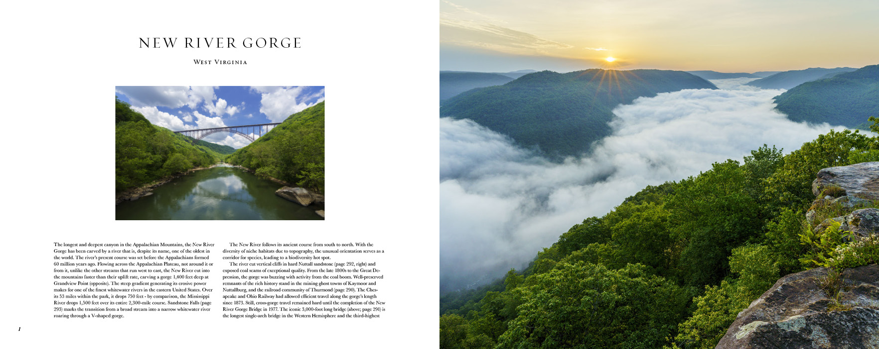
Photographing Grandview Point in New River Gorge
14 Comments
Thank you for providing feedback on images of New River Gorge. In this post, I go into more detail on the morning when the top contending photos were made, discussing their circumstances and differences.
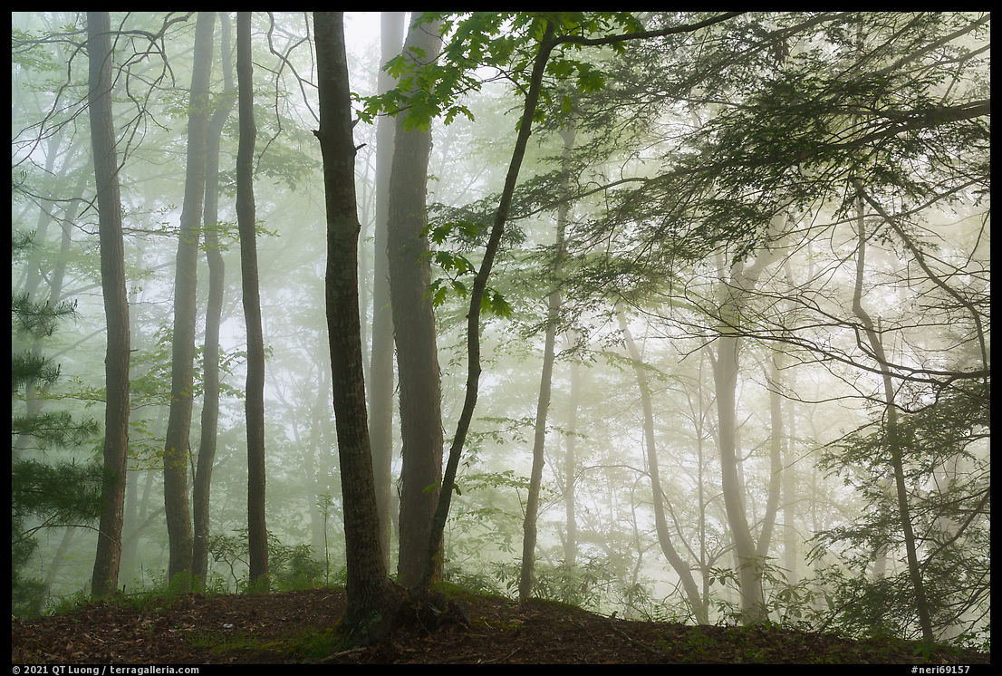
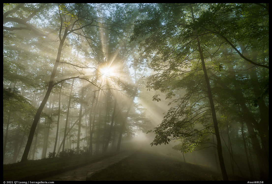
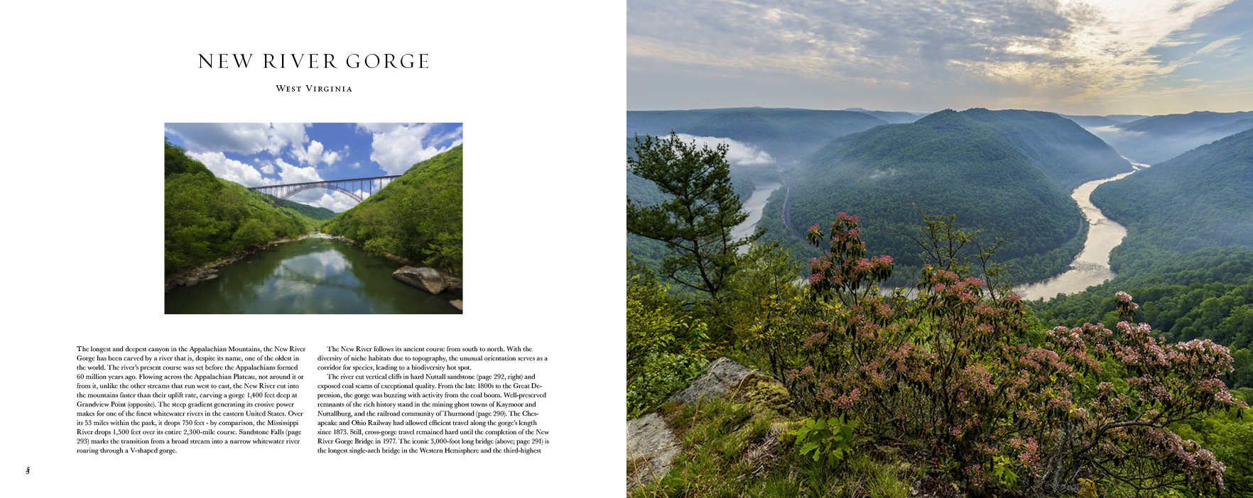
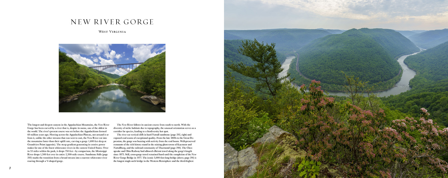
Grandview Point was my first destination in New River Gorge National Park and Preserve. On the first morning there, the fog reached above the rim, obscuring views of the gorge. Instead, I photographed in the forest, always a treat in the fog. I stayed around until the fog burned out. Those conditions, at the edge of the fog, often produce dramatic sun rays when photographed backlit. However, as beautiful as they are, those images do not inform about the New River Gorge.
By the time the fog had lifted, the sky was totally clear. The sun, backlighting the gorge, soared a bit too high. I spent half-a-day scouting the entire area. Starting from the Main Overlook, the 3.2-mile (round-trip) Canyon Rim Trail offers more choices of viewpoints and ends at the Turkey Spur Overlook, a rock offering 360-degrees views. I identified the two most promising viewpoints: the Main Overlook and the North Overlook.
I returned the next morning at dawn. The inversion was low enough for me to stand over the sea of clouds, however clouds on the eastern horizon diffused the sunrise. The contrast at sunrise was still challenging, but I later managed to make a few exposures with the large format camera. For this trip, I was severely limited because I had forgotten to pack a set of graduated neutral density filters. They are not part of my regular kit. I do not use them anymore for digital photography, but transparency film has much less dynamic range and a very narrow exposure latitude – a very unforgiving medium! I dust out my large format camera whenever a new national park is designated. Since I wasn’t there when New River Gorge National Park and Preserve was established unlike when White Sands National Park was established, I didn’t know if I would be the first to photograph the 63 national parks. Given that not too many folks these days try to photograph all national parks on large format film, I could still maintain my streak to be the first in doing so.
After COVID-19 delay, made it to New River Gorge National Park and Preserve, maybe still in time to be the 1st to photograph all 63 US National Parks? pic.twitter.com/CcnELsAFtN
— National Parks Photo (@treasured_lands) May 31, 2021
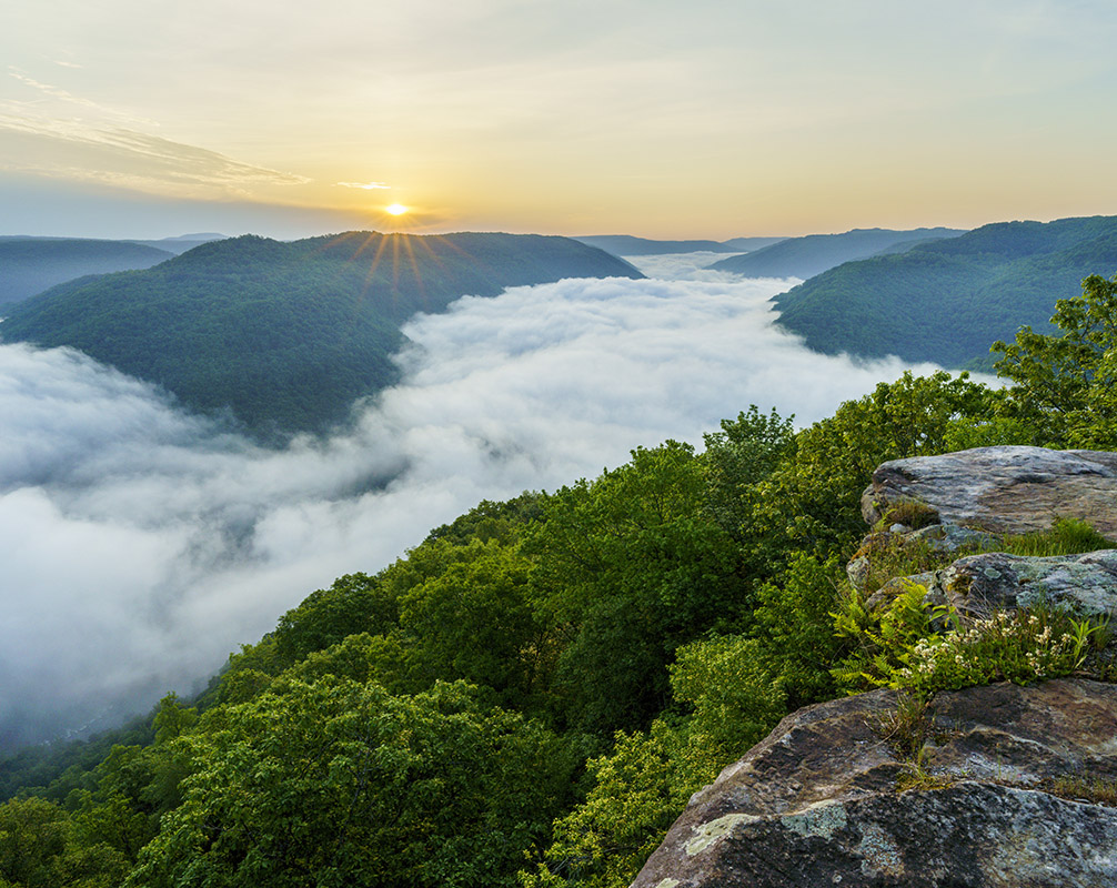
Having been there twice, I was tempted to skip Grandview Point on the morning of my last day in the park and visit another location at dawn. However, because it is a location with such potential and easy accessibility, I returned a third time, to find yet another inversion. Those seem to be a frequent occurrence in the spring, therefore morning fog is quite representative of the area, and inversions are not that common elsewhere, especially at non-marine areas of such low elevations. In the new edition of Treasured Lands, I now include all the highpoints, and on that occasion, I realized that Grandview is only 2,517 feet high. I was glad I went back since that third visit resulted in the top contending images. I started at the Main Overlook. It offers the clearest view of the horseshoe bend from a rock slab. A band of clouds was again present in the eastern sky, but it was smaller than the previous time, letting in some colors at dawn. Just when the sun emerged above those clouds, I photographed an image with a discreet sun star as it edged the clouds. Those sun star images always have the allure of capturing a unique moment in time. Besides the sun star, there is not enough light from the sun to really light up the landscape, which remains in beautifully soft light like at dawn. This image was the second most popular in the poll (30% of votes, cropped to 4×5 below).
A
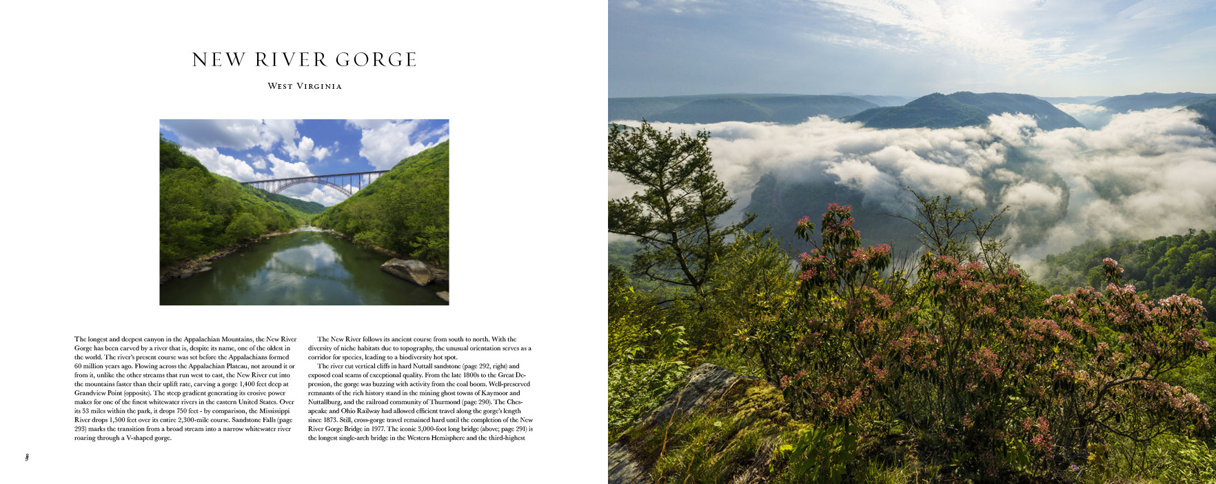
Moments later, as the sun emerged from the clouds, I photographed a more dramatic image in stronger light that was the third most popular (15% of votes) – that was #2 in the poll. As appealing and evocative as those images with the inversion were, they only partly show the gorge, and there lies a difficult choice.
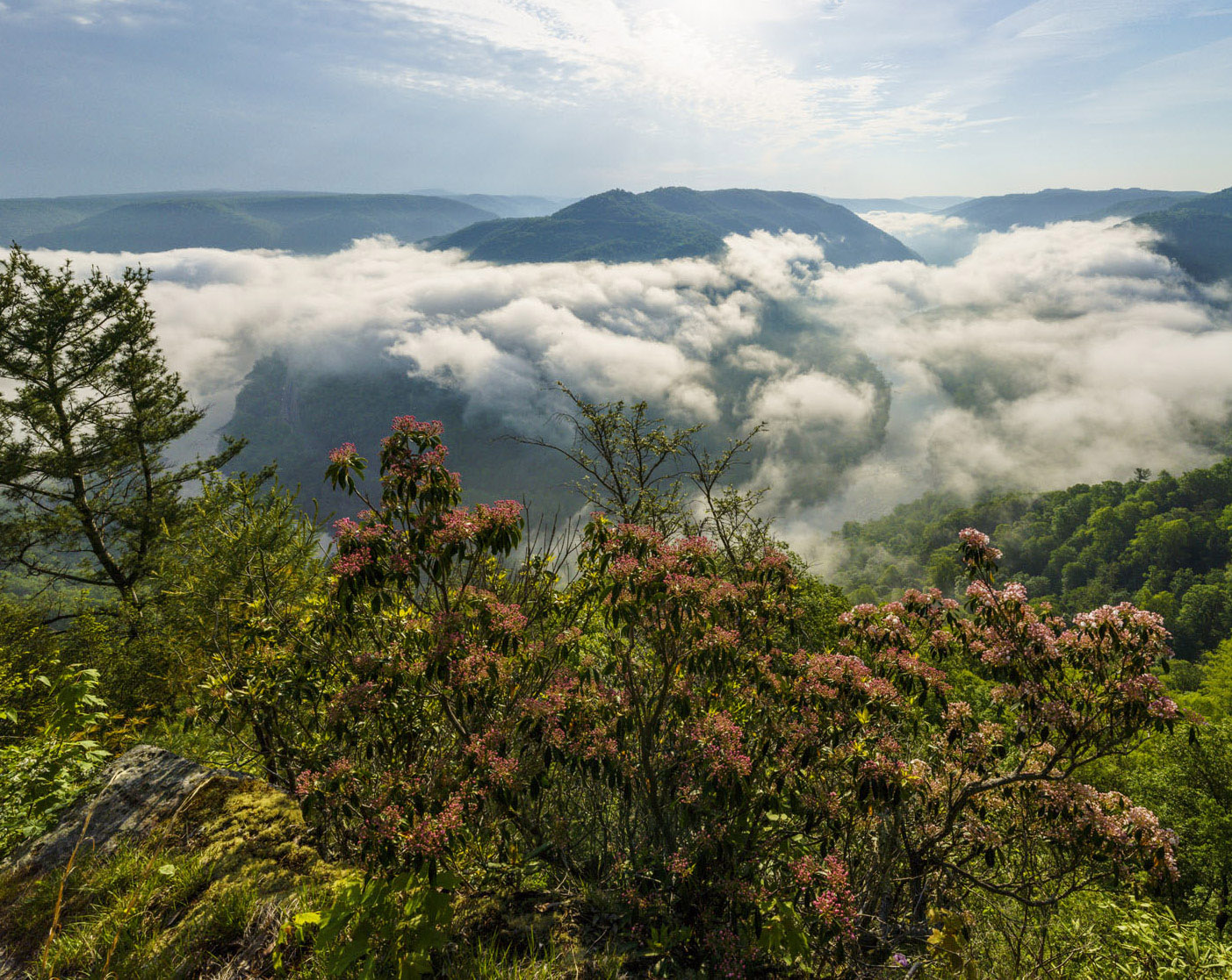
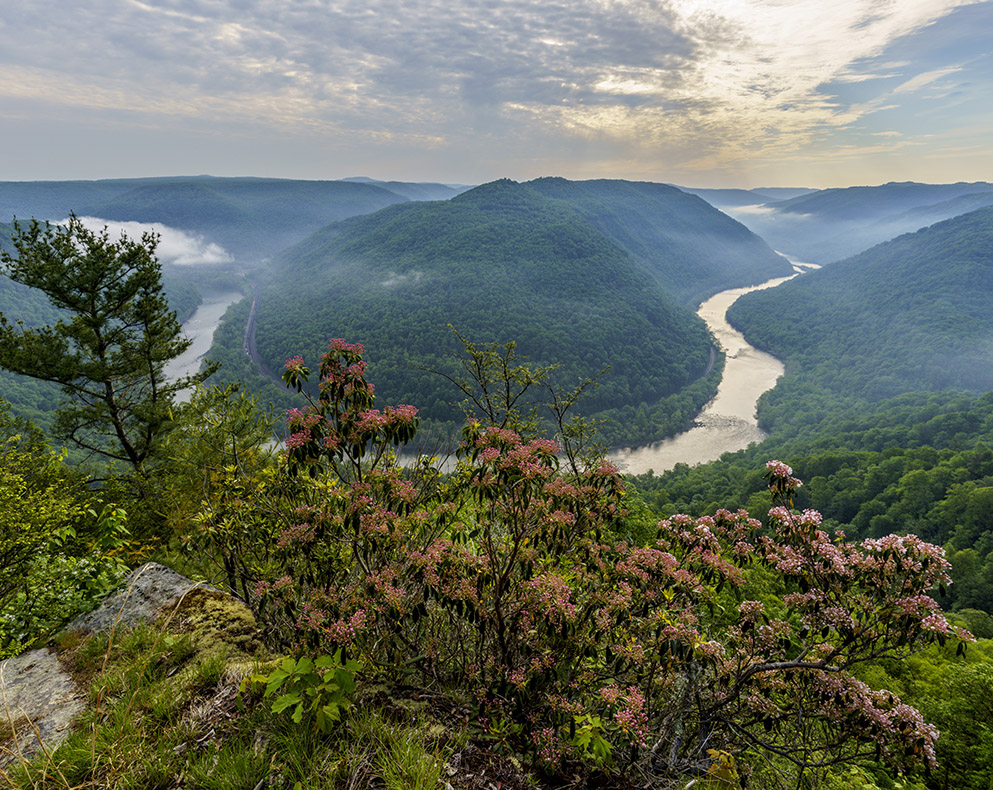
An issue with the Main Overlook is that the rock slab is marred by carved graffiti. In the heat of the moment, I didn’t always remember to exclude them from the composition (for instance in image #2 previously mentioned). I decided to continue the morning session at the North Overlook. While the view of the horseshoe bend from there isn’t as clear, a foreground of flowering vegetation was available. Mid-May was a bit early for the rododendrons, but a few were already blooming, with more budding. After I got there, the low fog started breaking up. I made an ultra-wide composition (12mm, #4 in the poll) before setting up the large format camera for a tighter composition (24mm, similar to #8 in the poll), I liked that moment because the river began to be visible, while there was still some fog, making for what I thought was an intricate photograph. On the other hand, it isn’t as legible as others. An experienced photo editor liked the tighter composition, but not the ultra-wide. He felt that the bright area of the sky high and centered kept the eye running on the middle of the frame. I think he is right, but I miss the left side of the bend on the tighter composition. It completes the horsehoe bend that is a unique landscape feature of Grandview Point. Based on the poll, this image was not a top contender, but sometimes just cropping an image can dramatically improve its composition, so I am giving it a second chance. Does this crop intermediate between 12mm and 24mm improve the image enough to make it a contender?
B
Once the fog breakup starts, it occurs quite fast. By the time I had finished making the large-format photographs, the fog had almost entirely dissipated (#9 in the poll). Shortly after, the light was also changing again, as the band of clouds on the left expanded to cover the sun and sky on the right. I made a photograph at 14mm while some of the mist was still hanging out and while the high clouds had not yet covered the entire sky. Like for the previous image, I had raised the tripod at a maximum height so that the river could be seen above the rhododendron plants in the foreground. Note that unlike the previous image, this one is not vertically cropped, which means that I had also adjusted the composition in the field like I did by cropping the previous 12mm image.
C
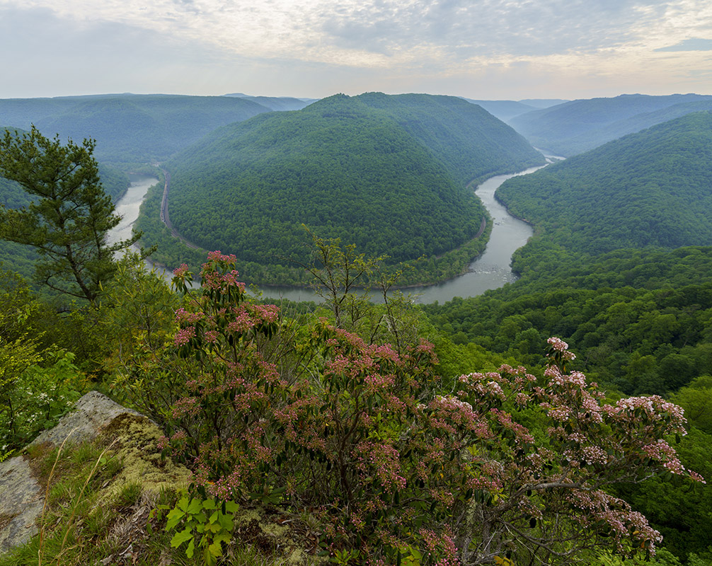
After photographing different compositions, the clouds had moved in to cover the entire eastern sky, making the light even, with barely an hint of fog left. I went back to the horseshoe bend composition, and realized that I could separate the foreground and the river better by moving a step forward to the edge of the slope and handholding the camera high – there was no way to place it in that position with my tripod. That image was the most popular choice (37% of votes, “D” below). I had initially skipped the image “C” in my edit because I remembered have taking steps to improve the composition from it, but forgot about the change in light. Ideally, I should have thought of this composition tweak for a clearer view of the river while the atmosphere in “C” was still there, but I didn’t. So now it is a choice, which one wins?
D
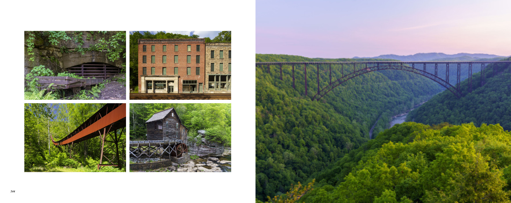
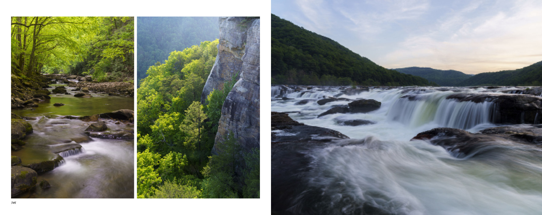
In the previous poll, I had presented the images full-frame, but that didn’t take into account that in Treasured Lands the main images are presented full bleed on a 10×12 inch page, therefore with an aspect ratio of about 5:4 instead of 3:2. Therefore, in this post, I have presented the images horizontally cropped to 5:4. Moreover, the main image is not standalone, but instead is part of a spread that will most likely use the river-level view of the New River Gorge Bridge. Of the four images considered now, the sunrise seems to pair with that image the worse, but maybe would work well for the back cover? That spread itself is not standalone, but rather is part of a set of three meant to feature the locations in the two previous articles. If the image was standalone, certainly it could not have been “A” because of the need to illustrate the gorge. I’ll let you judge if the images in the other spreads illustrate it sufficiently. This post has shown you how complicated it can be to choose a single image for the book, so I will just skip discussing the choice process and show you the result for the last three spreads. The back cover offers another spot for a New River Gorge image. Currently the results for that poll stand at Bridge 40%, Grandview 23%, Falls 37%, but that particular dawn Grandview image ranked low in comparison to A and maybe that viewpoint deserves two images of a different character?
Here are finalists for the first spread:
A
B
C
D
Here are the last three spreads:
The survey is closed. Thank you for voting, and see results in the next post!


I hope you have achieved all that you envisioned from the moment you realized photography had called you. Even more I await the next goal you set to attain. Thank you for sharing your joy and enthusiasm.
Warm regards,
Margi
p.s so excited to see the new chapter!!
Thank you for your kind words, Margi. When I started my project to photograph all national parks in large format more than 25 years ago, I did not even envision that photography would become my career, or that I would be publishing a book. But the more I dived into the world of photography, the more I realized how much I still had to learn, and how much work I have left to do.
Why?
Because (it’s there).
Thanks for sharing. It’s wonderful to be able to feel a part of your new book. Congratulations and good luck. Paul
Thank you for finding interest in my half-organized thoughts and hesitations.
I’m glad you have a timelapse river photo in your New River Gorge spread. Seems appropriate.
Are there any parks in US that you think should be the NEXT National Park? I can’t think of any myself, but I know you’ve traveled a lot more than most of us. Perhaps a new poll for a later email?
Half of our national parks started as national monuments. Current national monuments that come immediately to mind are Canyon de Chelly, Craters of the Moon, Dinosaur, Mt St Helens Volcanic, and Organ Pipe Cactus. For some of them, local activists have pushed for a re-designation without success so far. There are several other units of the National Park System that are as worthy as some of the existing national parks, for example, Glen Canyon NRA and Hells Canyon NRA. There are also state parks and national forests. My explorations have been focused mostly on national parks and monuments, but Zack Frank has done a good job going around the country and identifying potential future national parks in his Undiscovered America project: https://www.zackfrankphotography.com/Undiscovered-America
As QT Luong said, I set out to identify all of the places in the continental US that I think stand a good chance to become National Parks in the future. When I started the project I predicted that Pinnacles, White Sands, Indiana Dunes, and New River Gorge would all become parks. As they were designated I happily removed them from my project. (New River Gorge became one after the release of the book so it’s included among the 54 sites). Below is a list of the remaining 53 sites in my book:
Adirondack (New York),
Allegheny (Pennsylvania),
Ancient Forest (California/Oregon),
Assateague (Maryland/Virginia),
Atchafalaya (Louisiana),
Big Sur (California),
Black Hills (South Dakota),
Blue Ridge (Virginia/North Carolina),
Canyon de Chelly (Arizona),
Carrizo Plain (California),
Craters of the Moon (Idaho),
Cumberland Plateau (Kentucky/Tennessee),
Dinosaur (Utah/Colorado),
Driftless Rivers (Iowa/Wisconsin/Minnesota/Illinois),
Endless Mountains (Pennsylvania),
Finger Lakes (New York),
Ghost Ranch (New Mexico),
Glen Canyon (Utah),
Golden Gate (California),
Great Salt Lake (Utah),
Hells Canyon (Oregon/Idaho),
Imperial Valley (California),
Interior Highlands (Arkansas),
Lake Tahoe (California/Nevada),
Moenkopi [Coal Mine Canyon] (Arizona),
Mojave (California),
Mono-Inyo (California),
Monument Valley (Arizona/Utah),
Mount Hood and the Columbia River Gorge (Oregon/Washington),
Mount St. Helens (Washington),
North Woods (Maine),
Organ Pipe (Arizona),
Owyhee Canyonlands (Oregon/Idaho/Nevada),
Painted Hills [John Day Fossil Beds] (Oregon),
Palo Duro Canyon (Texas),
Pictured Rocks (Michigan),
Piney Woods (Texas),
Potomac Highlands (West Virginia),
Rim Rock Canyons [Colorado NM] (Colorado),
San Rafael (Utah),
Sandhills (Nebraska),
Sawtooth (Idaho),
Scablands (Washington),
Sedona (Arizona),
Shasta Cascade [Mt. Shasta] (California),
Silver Falls (Oregon),
Sky Islands [Chiricahua] (Arizona),
Superstition Mountains (Arizona),
Valley of Fire (Nevada),
White Mountains (New Hampshire),
Wichita Mountains (Oklahoma),
Wildcat Hills (Nebraska),
Wind River Range (Wyoming)
Thanks Frank, for providing the list to readers.
Thanks for sharing, understanding how you critique your own images is educational, your work is inspirational. Look forward to the new chapter.
Thank you for your interest. It’s a bit different from a critique in the sense that the illustrative purpose of the image is also considered.
QT,
Thanks for giving us insight in on all the decisions you’re making to add just one new chapter. Fascinating.
I think A is the most dramatic, and though it lacks the river the viewer can easily imagine the river and the bend below the fog. D is the most technically precise composition but offers the least drama. B combines drama, atmosphere, and a hint of the actual river. I think I’d go with B if it was by itself, but when you share the full spread of the page, since you’ve got the clear view of the river with bridge, I lean toward A. It is less “informative” than the other choices, but makes me say, “I want to go there!”
Thank you for the comment. Actually, the decision is in adding just one image! I’ll comment on the choices made on the entire chapter when the new printing/edition is released.