Day Hiking Paria Canyon
6 Comments
Day 11
Zion National Park’s Virgin River Narrows is arguably the most famous canyon hike in the world. Being that Zion National Park is the 7th most crowded national park (per this way of evaluating the “crowd factor”), the Virgin Narrows can feel downright crowded (Five ways to photograph the Zion Narrows without people). The Paria Canyon in Vermilion Cliffs National Monument is twice as long as the Zion Narrows, and every bit as impressive. During an entire day of hiking, I was mostly alone, meeting only about a dozen of backpackers.
The Paria Canyon, extending for 38 miles from the White House Trailhead in the north to Lee’s Ferry in the south traverses the entirety of Vermilion Cliffs National Monument. It is a premier destination for canyon backpacking in the Southwest as it combines great beauty with relatively easy terrain. The winding corridors of stone soaring hundreds of feet above the Paria River explode with colors as they cut through seven geologic formations: Moenkopi, Chinle, Moenave, Kayenta, Navajo Sandstone, Temple Cap Sandstone, and Carmel. Although there are impressive narrows, the canyon has a relatively open feel and its flat and sandy floor has few obstacles with the Paria River a narrow ribbon most of the time ankle-deep and rarely knee-deep. It makes for a fun wet hike easier than the Zion Narrows, during which you cross the river hundreds of times and wade in the river when it spans the whole width of the canyon. When getting ready, I wondered whether to bring hiking poles, and I was glad that I did. Paria means “muddy water” in the Paiute Indian language. Since you cannot see the bottom of the riverbed and there are spots of quicksand, they proved very useful. I expected only shallow water, so I didn’t bring chest waders, as I thought hiking a long distance with them wouldn’t be comfortable.
Permits subject to a 20 person per day quota that can be reserved up to 4 months in advance are required for overnight trips, but not for day trips for which you just pay a fee at the trailhead. Due to the risk of flash floods, it is best to avoid the heaviest part of the monsoon season, late June to mid-September. December through February is very cold, and fires are not allowed in Paria Canyon. In late October, the weather was pleasant during the day, although a little chilly at night. This makes that time popular, and without an advance permit, I planned a day trip. It is a 15-mile round-trip hike from the White House Trailhead to the confluence of the Paria River and Buckskin Gulch, a narrower and more difficult canyon considered to be the longest slot canyon in the world. Although in late October, the dozen other people I saw were all backpackers, I did not feel that the hike was particularly difficult to complete in a day.
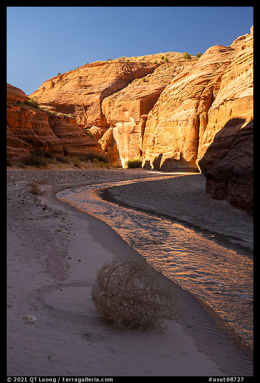
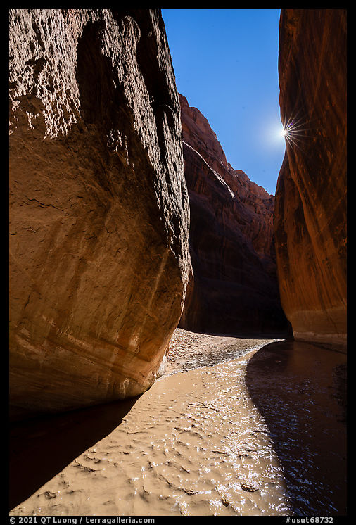
I started to hike at 6:30 AM, more than an hour before sunrise, as my plan was to arrive at pre-dawn at the Paria Windows, a series of holes carved in the cliff, about 2 miles from the trailhead. This part of the Paria Canyon is another part that has been removed from Grand Staircase Escalante National Monument. The best compositions required standing in the water for the long exposure time. It was hard to do. I regretted not having my neoprene socks for this trip. My feet were hurting so much from the cold water that I considered turning around and grab my waders, but at that point it would have meant adding more than 4 miles to an already long hike. Fortunately, the canyon was still wide and open past the Paria Windows and there were long sections of dry trail in between river crossings. When crossing, I tried to go as fast as possible, a shorter immersion in water made a difference. Later in the day, by mid-morning, the air and water temperatures had warmed up enough that stepping in the water became bearable.
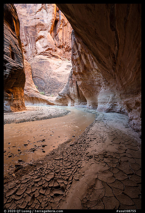
As I hiked further, the canyon grew more narrow. At around mile 4, the river spanned most of the canyon, save for a narrow band of muddy ground. Due to the relative popularity of the hike, and the fact that there hadn’t been any flash flood for months at that point, instead of beautiful virgin mud patterns, most of that ground was churned out with footprints. I looked hard for pristine spots of mud, but couldn’t find any along the main pathway. Only at a few spots where the banks were wider on one side and very narrow on the other side, therefore making the wide side an obvious path, by crossing the river I could find such spots. For that reason, I made few wide-angle compositions, and instead minimized the foreground by including more of the canyon walls.
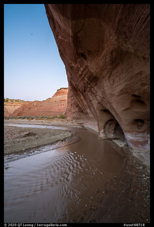
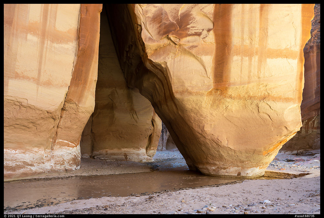
At around mile 6.7, the river flowed through a massive natural arch called Siderock Arch. When I got there, the sun was reaching the bottom of the canyon, creating distracting bright spots. However, those canyons are so narrow and deep that the light changes much faster than it does on open terrain. I didn’t have to wait that long before the sun left the base of the arch.
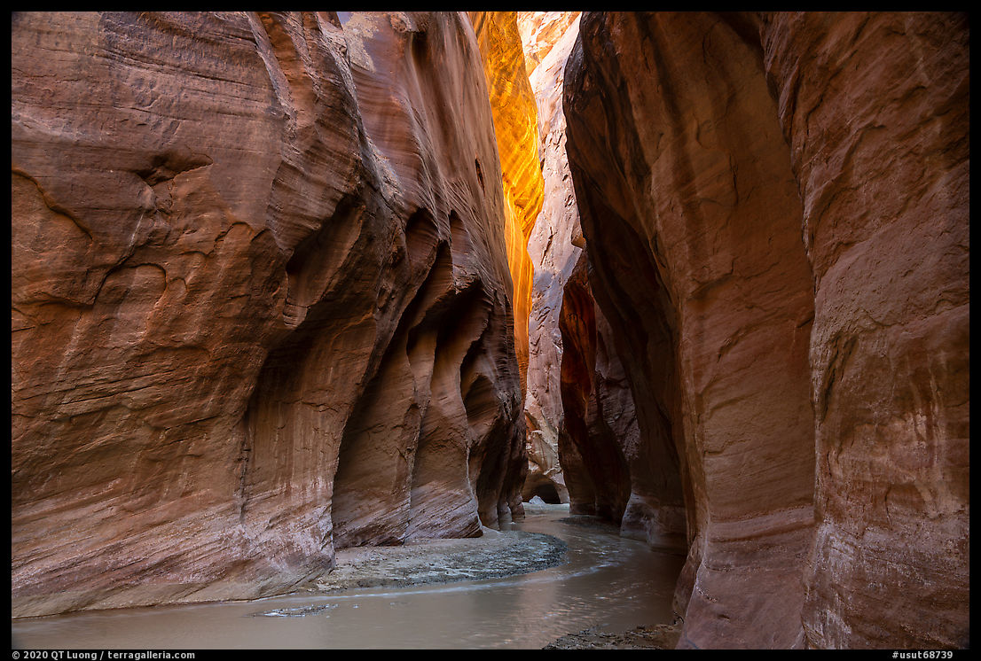
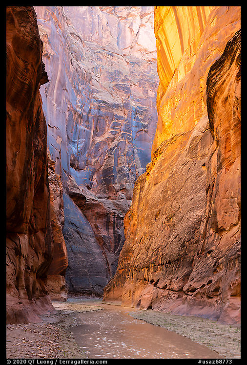
Half an hour past noon, I reached the confluence at around mile 7.5. The narrows were the most impressive around that area, as the walls were highest and close to each other. I continued in Paria Canyon, looking for reflected light that creates a warm glow on the canyon walls. Later, upon arriving at a sunny spot, I stopped for lunch, enjoying for a brief moment the warmth of the sun rays before turning back.
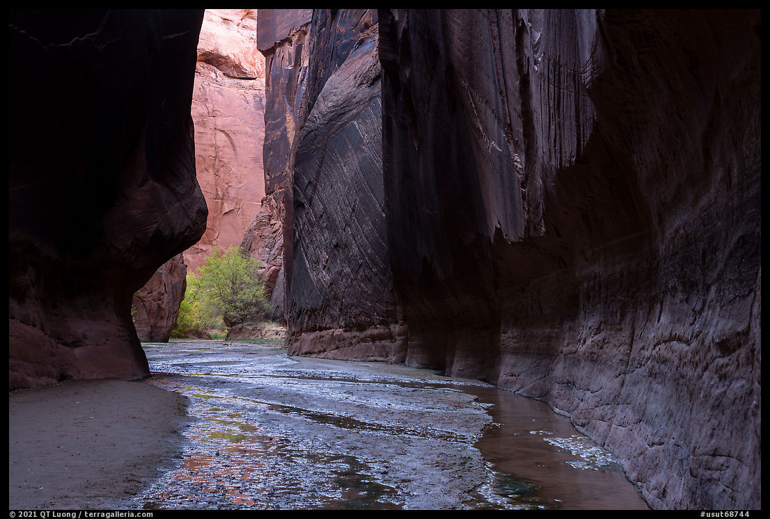
On my way out, I ventured shortly into Buckskin Gulch. That canyon was darker than the Paria Canyon, and unlike the fast-flowing, chocolate-colored Paria, the Buckskin was clear, flowing lazily, and often only about an inch deep. Unless one plans to hike the entire 15 miles of the Buckskin Gulch, it is much quicker to approach it from its other end near the Wire Pass Trailhead than from the Paria.
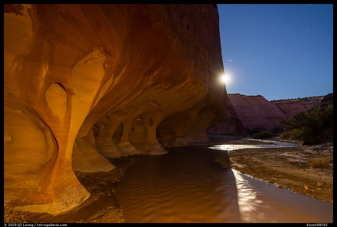
I came back to the confluence at around 3:30 PM. I was hoping to reach the Paria Windows at dusk where I expected the light to be better than at dawn, but by the time I got there, it was already nighttime with any residual light from dusk gone. However, noticing that the almost full moon was about the rise over the canyon, I got in position to photograph. Fortunately, the water had warmed up during the day. Even with sun gone, it was not painfully freezing like in the morning. I stepped into river to align the moon with the edge of the cliff, creating a star effect. The shaded area would normally be too dark to reveal the details in the hole, so I lighted it with a flashlight during the long exposure. Since the low moon was moving fast, I wouldn’t get a second chance at the same composition, so I was overjoyed when I saw in the LCD that I had given added just the right amount of light to create a glow comparable to what brighter reflected light would have done. Afterward, I walked straight without stopping any more for photos and arrived at the trailhead at 8:30 PM.
The Last Road Trip: 1 | 2 | 3 | 4 | 5 | 6 | 7 | 8 | 9 | 10 | to be continued


Your passion for what you do shows in your determination to get to your destination, no matter what. I don’t think I’d be willing to go it alone.
I can see your effort in your wonderful work. I greatly appreciate your photos for which you work so hard. Extraordinary.
Thank you for the kind words, Dennis. That hike is no big deal solo. In season there are several groups daily and they would find you if you run into problems. Cold feet, though… almost turned around.
Hey I was just there two days ago. Went to Buckskin Gulch agreed lo ger way to reach coming from the back. Great tip.
Yeah I hiked Buckskin Gulch from Wirepass TH today. I wouldn’t put the extra miles in from the White House trail to that point just to see it.
Great work, QT! Looking forward to publication- any estimate for that?
Hopefully Sept 25 this year for National Public Lands Day.