Sunrise at Petes Mesa, Canyonlands National Park
No Comments
It is rare to find yourself at a location with a spectacular view in all directions, and even rarer when that location has been photographed only by a few. This post shows a variety in space and time of images made at sunrise from a single viewpoint at Petes Mesa in the Maze District of Canyonlands National Park, during the Maze Canyonlands 2013 Photo Tour.
The hike starts from the Chimney Rock trailhead (map). With the appropriate high-clearance 4WD vehicle – stock SUVs may not be enough for most drivers – you can drive 37 miles from the Hans Flat Ranger station to there in about 5 hours. Otherwise, there are two options for backpacking in, both of them taking a long half-day: you can drive down the Flint Trail switchbacks – steep but not too rocky – to the top of the Golden Stairs with any 4WD in dry weather, or you can be dropped by jet-boat at Spanish Bottom in the summer. Water sources are rare and found only down the canyons.
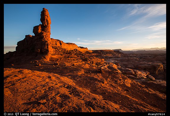
The Petes Mesa trail is primitive enough that it is referred to as a “route”, however it is reasonably well marked by cairns, and the terrain is not difficult, as you are mostly walking on rock slabs. We followed it until it made a sharp left turn to descend into the Maze. At that point, we continued on the ridge to the edge of Petes Mesa, at the base of a rock tower typical of the Land of Standing rocks, looking North.
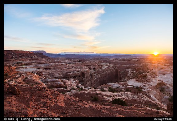
This is looking North-East towards the La Sal Mountains and the rising sun. Our 5am start placed us there half an hour before sunrise, which in mid-October happens around 7:30am (to figure that out I like www.sunrisesunset.com).
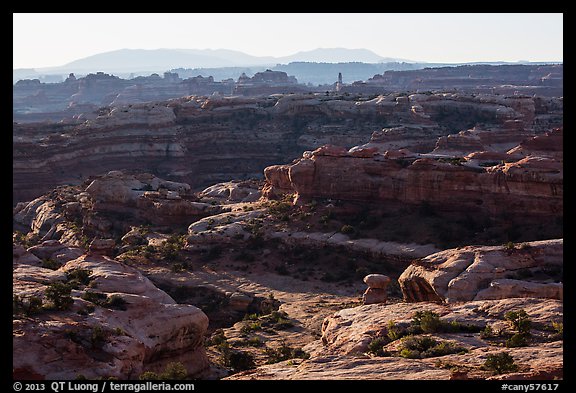
On the East, Jasper Canyon is totally off-limits to human travel, in an effort to keep intact one of the most pristine canyons of the southwest – unlike others, it was never grazed.
On the South, lie the Land of Standing Rocks. The rock formation on the horizon is Chimney Rock where the trailhead is situated, about 4 miles away from Petes Mesa.
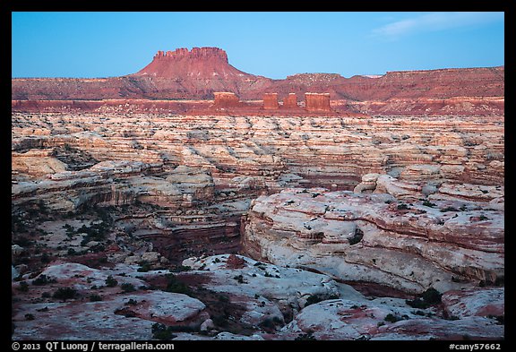
On the West, the aptly named Maze, bounded by the Elearite Butte, forms a thirty square mile convoluted puzzle inscribed in sandstone, with more side canyons you’d think possible in such a small area. 20 minutes before sunrise, the sky, not yet illuminated by the sun, is still blue, while the land reflects the warm glow of the horizon with delicate tonal gradations.
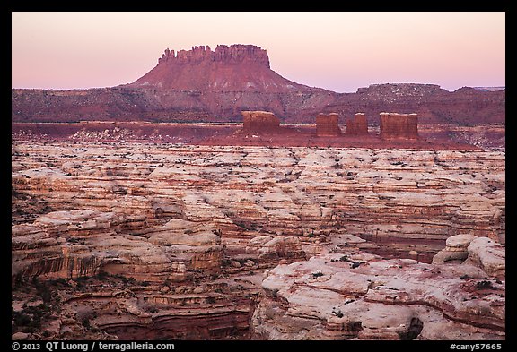
Between 10 to 5 minutes before sunrise, both the sky and land are bathed in a warm glow, which disappears quickly from the sky as it gets directly lighted by the sun.
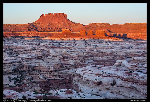
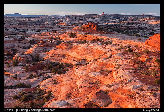
The Chocolate Drops, a slender formation of Organ Rock Shale capped by White Rim sandstone, forms an important navigational landmark for hikers. A few minutes after sunrise, their shadow help outline their shape despite the scene being almost front-lit. At that time, the lit part of the land glows a bright red. The part in the shade is quite dark, but for a brief instant, the contrast is low enough that the latter can easily be brightened in post-processing even if a graduated filter was not used at capture time.
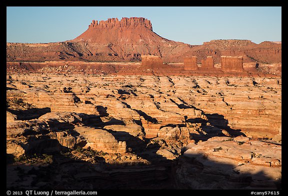
Half-an-hour after sunrise, the upper part of the scene now lacks shadows, but they are still present in the bottom part to impart some depth. Afterwards, it was time hike into the Maze, where steep walls offer favorable light even mid-day.
Sunrise at Petes Mesa was actually an improvisation. We were to camp at the Maze Overlook, possibly the best panoramic viewpoint over the Maze, situated on the opposite side. Navtec had secured a campsite there six months in advance of the trip, but we lost our reservation when the trip was moved because of the National Parks shutdown. The Maze Overlook site fills up fast as it is more easy to access by road than those at the Land of Standing Rocks, which require driving through Teapot Canyon, the most difficult road in the Maze. The distance from our Standing Rock campsite to the Maze Overlook is just 4 miles as the crow flies, but it takes 5 hours by road, for just 34 miles. Since everybody preferred to hike rather than sit in the car for 5 hours of bumpy roads (plus 1.5 hours of backtracking), we stayed for a second night at Standing Rock, and hiked to Petes Mesa for that view of the Maze from above instead of the Maze Overlook view.
Although it has been photographed considerably less than other views from Island in the Sky, the Maze Overlook is somehow a classic. On the other hand, given that one needs to hike in the dark for four miles, I doubt that more than a few photographers have captured the sunrise from Petes Mesa. Will you be the next ?
View more images of the Maze District of Canyonlands

