Grand Staircase-Escalante National Monument: Cottonwood Canyon Road
5 Comments
Grand Staircase-Escalante National Monument, the largest national monument in the continental United States, was established on this day in 1996. Such a large, and mostly undeveloped area can be intimidating to explore. In this article, I take you along the easiest of the monument roads that explore its vast interior, the Cottonwood Canyon Road, along which you can see colorful badlands, an outstanding extended rock formation, narrow canyons, and a towering natural arch.
The main access to the monument is through two east-west highways, US-89 to the south and UT-12 to the north, but those roads only border the monument lands. To explore the monument’s interior, you have to drive one of the south-north roads that are all unpaved. From west to east, they are: Johnson Canyon – Skutumpah Road, Cottonwood Canyon Road, Smoky Mountain Road, and Hole-in-the-Rock Road. Of the four, the Smoky Mountain Road that crosses the Kaiparowitz Plateau is by far the most difficult, least maintained, and also the least scenic. The Hole-in-the-Rock Road and Johnson Canyon Skutumpah Road give access to remarkable sites: see Dry Fork Coyote Gulch and Forty-Mile Ridge and Skutumpah Road in previous posts. Yet, the most scenic and easiest to drive of the four is the 40-mile Cottonwood Canyon Road that links US-89 to UT-12. The last time I traversed the road in the autumn, the only slightly problematic section was a sandy stretch at the southern end near US-89. By making sure to keep momentum, my low-clearance, 2WD, Prius had no trouble negotiating it. However, make sure to check the weather forecast and inquire about the road conditions at one of the numerous visitor centers surrounding the monument, since rain can transform the road into a muddy mess impassable even for 4WD vehicles.
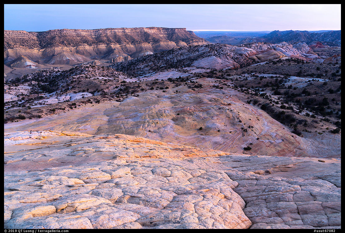
Yellow Rock
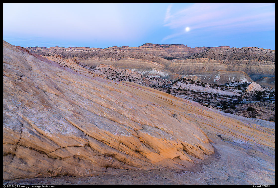
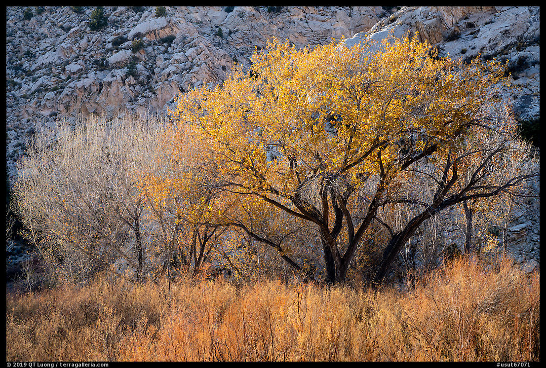
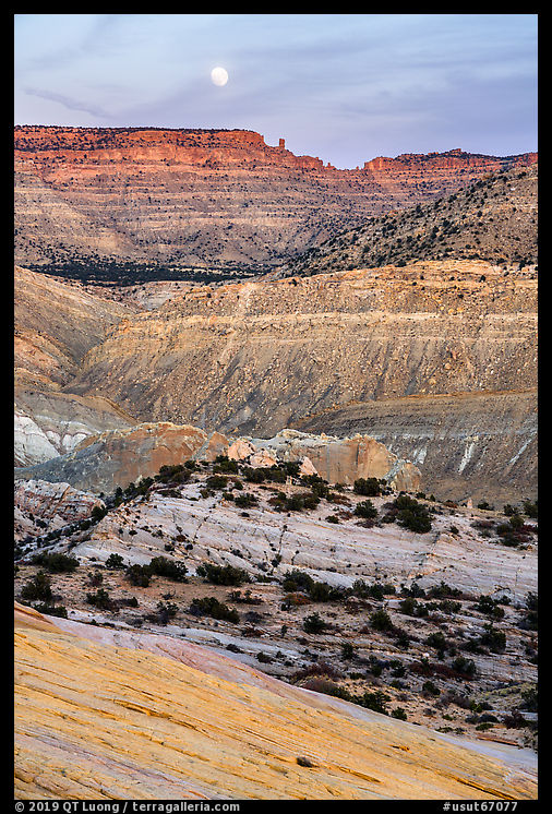
The southern section of Cottonwood Canyon Road traverses colorful badlands and follows a river valley lined up with cottonwood trees. In early November, the fall foliage was beautiful.
The highlight of that section was Yellow Rock, about 14 miles from US-89. I parked near the junction with the steep Brigham Plains Road. From there, at the bottom of the valley, the huge formation is not visible. I walked towards the west across a dry wash, looking for a gully cutting the plateau wall, where I followed an extremely steep trail for about fifteen minutes. Upon setting foot on the plateau, I was astonished by the sudden sight of the massive dome of swirling and cross-bedded Navajo sandstone, multicolored but mostly yellow as implied by the name. The formation loomed impressively and looked absolutely massive from the base. If the formation had been located anywhere else in the country, it would by itself justify federal protection. There is of course a lot of slickrock in southern Utah, but still, compared to other formations, this one is quite remarkable in its size and pure form. The light on Yellow Rock is best in the late afternoon, but the main face goes in the shade about forty minutes before sunset. At that time, the light just grazes it delicately. By framing a distant foreground with uniform texture and that relatively even grazing light as opposed to a closer foreground with lines and more contrasted light, I made images conveying different impressions of the rock. One of the images was photographed with a superwide 21mm, whereas the other used a modest wide angle of 28mm. Can you guess which lens was used for each picture? (answer at the end).
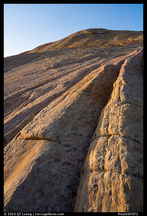
Hiking is generally on trails, but walking to the top offered the exhilarating experience of scrambling on a sea of bare rock for an extended time. Yet, despite its intimidating slope and smooth aspect, the friction was adequate and the angle was low enough that the walk up was straightforward, not requiring the use of hands. It was only one mile and 800 feet elevation gain from the Cottonwood Canyon Road. Yet, as the dome is higher than its surroundings and denuded of vegetation, the 360-degree panorama at sunset revealed so much of the area’s exceptional geologic diversity. I lingered in awe on the top until half an hour after sunset. On the way down, the full moon was so bright that I could make my way on the rock without a light. I wished I had come earlier in the day, as the rock and surrounding area are full of photogenic patterns, textures, and way more colors than reds. The area would reward repeated visits, since it is so large that one cannot photograph all of its features with the best light on a single trip. Since I was hiking by myself, I took care not to slip going down the steep gully. By the time I got back to my car, I hadn’t seen a single person.
Grosvenor Arch
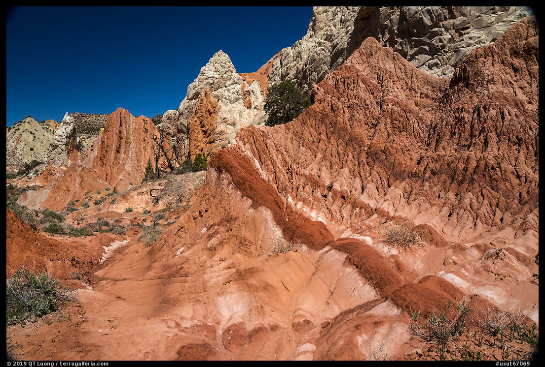
About a quarter-mile from the Brigham Plains Road junction, a trailhead leads into the narrows of Lower Hackberry Canyon, the best part of it ending about a mile and a half into the canyon. About 11 miles further north, lies the entrance to another canyon, the Cottonwood Wash Narrows, which is shorter. However, the attraction that caught my eye the most was along the road: an area of pinnacles and badlands so vividly colorful it has been called Candyland line up the road’s east side.
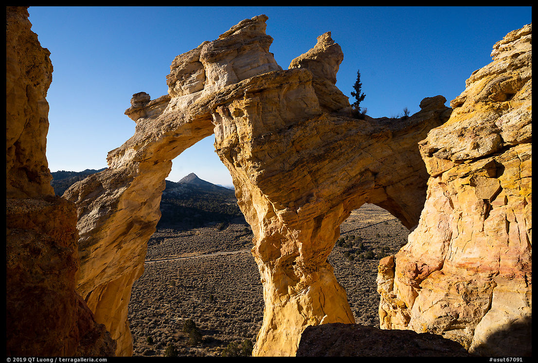
About 30 miles from US-89, a turn-off from Cottonwood Canyon Road leads to Grosvenor Arch. It is the most accessible feature along Cottonwood Canyon Road, as a short, paved trail leads to its base and there are amenities such as toilets and picnic tables. Spanning an impressive 90 feet and rising 150 feet, the west-facing double arch is one of the monument’s landmarks. Grosvenor Arch is best lit in the late afternoon, as in the morning its frontside is in the shade. Usually, you don’t want your main subject to be darker than the surrounding objects – such as the pinnacle on the left. If you don’t like what natural light does, just bring your own! I started to photograph at pre-dawn time, when the ambient light was so dim that I could illuminate the arch with a lantern, bringing a warm glow, subtle enough that most viewers wouldn’t realize that it is artificial. You can notice the difference with the photograph I made 40 minutes later when it used only natural light as at that point the ambient light was too bright for the lantern to have any effect. The arch is now a bit dark, yet because of the softness of the pre-sunrise light, it is not dominated by brighter areas of the pinnacle to its left the way it would be after sunrise. Although backlit, the light tone of the Dakota Sandstone still stood out against the blue sky with the aid of a polarizing filter.
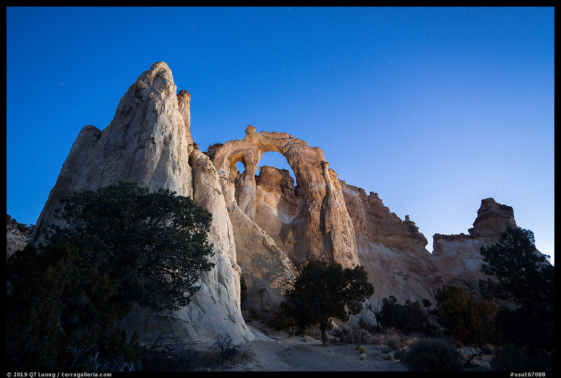
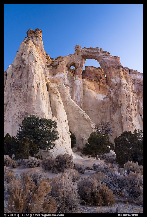
After the sun rose, to try a different perspective, and photograph the lit side of the arch, I scrambled up the back of the arch through a steep user path to photograph the two openings from behind. Nowadays, Mesa Arch in nearby Canyonlands National Parks has become so popular with photographers that showing up at sunrise time usually won’t be enough to secure a spot in the shoulder-to-shoulder line. Its popularity is due to the setting, the landscape framed by the arch and the wall below creating the reflected light at sunrise, rather than the intrinsic features of the arch. In a land full of natural arches (nearby Arches National Park has more than 2,000), Grosvenor Arch still stands out because of its size and unusual color. Most other arches are reddish Estrada Sandstone, but Grosvenor Arch is light yellow. Despite its ease of access, from dawn until I left the area, I had the entire place to myself.
The horizontal photograph of Yellow Rock was made with 21mm. Surprising?


Fabulous pictures, QT. Thank you so much for the inspiration to go visit one of our true national treasures!
Steve
Thanks Steve. Grand Staircase-Escalante is a crown jewel among the national monuments.
Thank you again for showing us some beautiful parts of our lands. I’ve been to Grand Staircase/Escalante several times, but I’ve yet been able to travel the Cottonwood Road due to either timing or weather. It’s still on my list. As usual, great shots!
The conditions on this road can indeed vary from quite easy to impassable depending on the weather.
I enthusiastically agree with your comments about this area! In Spring 2022, my wife and I spent 10 days in Big Water, exploring the areas around Cottonwood Canyon Road and Skutumpah Road and much more. Fantastic area. I planned four afternoon/evening visits to Yellow Rock, since it is impossible to cover all there is to shoot in the limited time of good light on one day. The hike up from the wash is not pleasant but not really a problem unless one is bothered by steep slopes. My favorite view of Grosvenor Arch was at sunrise, looking pretty much straight up, when the sun lit the inside of the arch. My experience was the same as yours; on my multiple visits to Yellow Rock I was the only person there, and on our two visits to Grosvenor Arch we were the only people there. I hope it stays that way!