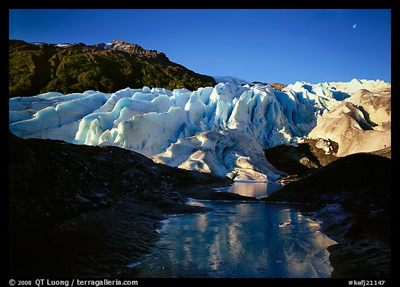
Photo spot 53: Glacier Bay National Park – Mc Bride Inlet
Glacier Bay National Park is centered around the Y-shaped fjord of the same name on the Southeast coast of Alaska. The Bay is sheltered from the ocean by the Fairweather range, the tallest coastal range in the world. Only two hundred years ago, when Captain George Vancouver sailed by its mouth, he saw a solid sheet of nearly a mile of ice. One century later, the glaciers had shrunk back 65 miles, the fastest glacier retreat on record. Southeast Alaska weather is notoriously difficult. Ansel Adams visited in September and didn’t get far because of the rain. The only three well-known images from his visit are a field of grass in the rain, and two close-ups, one of grasses, and the other of a leaf. Since I intended to reach the glaciers for which Glacier Bay is named, and which are its main attraction, I timed my visit for the spring, when the weather is the most favorable. I chose to arrive in May rather than June to see more ice in the fjords, as well as fewer cruise ships.
The only access to Glacier Bay National Park is either by boat or by air. Since I arrived before the main tourist season, Alaska Airlines had not yet started its flights into Gustavus, Glacier Bay’s airport. I flew into Juneau with my two “body bags”, huge army-issued duffel bags that were each large enough to house my wife, and loaded with 70lbs of gear. Fortunately, back in 2001, the airlines did not charge extra for that kind of luggage! I then boarded a short commuter flight for Gustavus, and from there a shuttle to the National Park visitor center, where my partner for this trip was waiting.
I had met Arnd Pralle, a German researcher in physics, after giving a slide show for CHAOS, the UC Berkeley student outdoor club. During the presentation, I mentioned that I was heading for Glacier Bay in a month. Arnd introduced him afterward to ask if he could join. I was glad to have his company because I had no experience paddling a kayak at that point. I had only taken an afternoon clinic in Santa Cruz so that I could tell the concessionaire that I had received instruction – they wouldn’t rent me a kayak for a solo expedition otherwise. Arnd was neither a seasoned kayaker, but he had plenty of experience as a yacht skipper, which would prove useful as the marine environment of the Bay is extremely dynamic, with some of the highest tides – and strongest tidal currents – that I had seen.
The vast majority of visitors to Glacier Bay see the park from a cruise ship. However, from the high deck, one can take only distant images, which do not show a real connection to the land. Moreover, cruise ships are not allowed into the wild Muir Inlet. With a kayak, we hoped to be able to experience the vastness of the bay through a low waterline, observe closely wildlife thanks to our quiet vessel, cross narrow channels and iceberg-chocked passageways not accessible to boats, paddle and land as close to the glaciers as possible, and camp on isolated beaches. The glaciers are at least 50 miles away from the visitor center, but fortunately, the Park operates a day tour boat that can drop off and pickup kayakers. The dropoff points – which change each year – are still a long way from the glaciers, but at least, we wouldn’t have to paddle the lower Bay.
Because of a persistent drizzle, the daybreak felt dark and gloomy. After loading our double kayak onto the tour boat, we gathered our gear into large clear plastic bags to protect it from the rain. Upon dropoff, we stuffed it back into the double kayak. Although one cannot load a large item, such as a large backpack, it is surprising how much you can fit on board if you proceed with a method: food for almost two weeks in bear canisters, a tent each, and three camera systems (35mm for each of us, plus my large format).
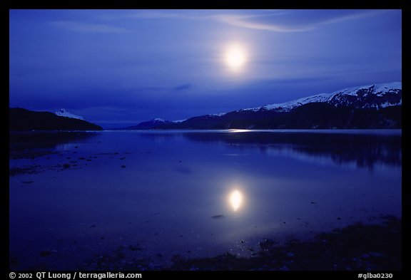
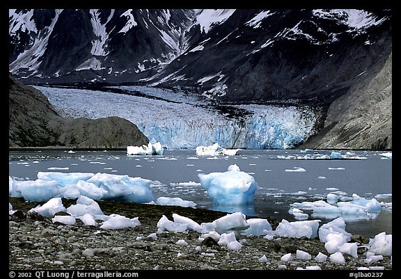
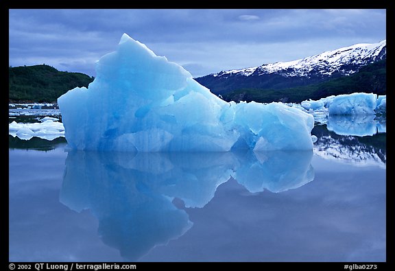
Starting to paddle in the late morning, we took our first stop only at dinner time, cooking there so that our final camp would not have bear-attracting smells. We initially expected to stop when it would get dark, but at those latitudes, it doesn’t get dark. We kept paddling, taking advantage of the advancing tide, and of a break in the rain. One more hour, then one more hour … This took us to our destination, a grassy flat near the mouth of McBride Inlet, at 2am. I had spotted that area on the map as a place with great photographic potential because it was located next to a narrow inlet in which the McBride Glacier calves. Besides the direct view of the front of the glacier, I thought that the icebergs originating from the Mc Bride Glacier would likely be stranded in great numbers on the flats near the narrow outlet channel of the inlet – were, by the way, the tidal currents are too strong for paddling.
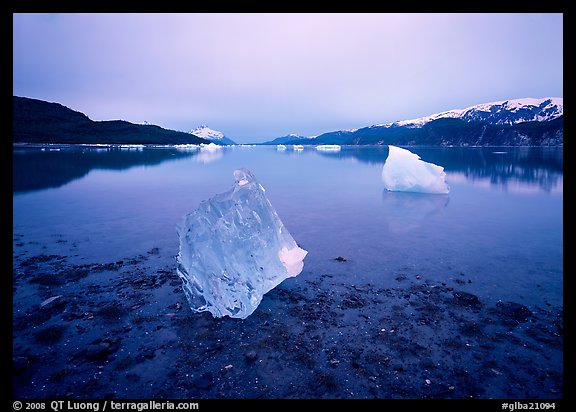
By the time we had finished setting up camp, it was 3am. It was now a bit too dark to see if my planning was right, but the reflection of the moon over the Muir Inlet was beautiful. After taking a few images, I retreated to my tent. However, I couldn’t go to sleep despite the long day of effort. I felt excited by possibilities and energized by the clear sky and the lingering half-light of the Alaskan summer, that I could see growing brighter outside. The world felt so beautiful and just invited exploration. After being awake for almost 24 hours in this intensely wild and pristine place, I felt myself in a curious state of heightened awareness. I wandered around the tidal flats until I saw a translucent iceberg lying more than a hundred feet away in water. However, the water was very shallow, and I understood that with the fast rate at which the tide was receding, if I waited, it would be totally out of the water. I left my camera bag on the mud, and wadded into the water with just the camera mounted on a tripod, the focusing loupe and dark cloth around my neck, and a film holder in my pocket.
After sleeping in the morning, we would find more great views near the glacier, but those first few images of the trip remain my favorites.
View more images of Glacier Bay National Park
View more images of Mc Bride Inlet
 To make an already long story short, as you can see on this page of