Hanford Reach National Monument: From the Bomb to Nature Refuge
2 Comments
Hanford Reach could the national monument with the most unusual history of all. Its lands, located in Eastern Washington, were initially set apart from development not for conservation, but as a security buffer zone for the top-secret Hanford Nuclear Reservation where the plutonium for the Nagasaki bomb – and many others during the Cold War – was manufactured, and which became the most polluted site in the Western Hemisphere.
After the end of the Cold War, the decommissioning of the Hanford Site’s nuclear reactors was followed by a cleanup that continues to this day, and to the establishment, in the year 2000, of a vast nature preserve in the buffer zone that surrounds it. The Hanford Site once provided most of the jobs in the area, but agriculture has quickly taken over. Without the nuclear activity, the former buffer zone, which now stands between industrial agriculture and a Superfund site, would have certainly been developed, especially since the unassuming lands are not home to any significant landform. The mighty Columbia River is heavily dammed, and its last remaining free-flowing section, which stretches 51 miles, is called the Hanford Reach, hence the national monument’s name.

The river in the Reach is lined up with islets, ponds and sloughs that have all but disappeared in the other sections of the Columbia, supporting one of the most productive salmon spawning areas in the Northwest. By contrast, most of the terrain of the monument is desert covered by the largest remnant of the shrub-steppe ecosystem that once blanketed the Columbia River Basin. The area receives between 5 and 10 inches of rain per year.
Approaching the monument, I was struck by the vastness of the area, but also by how dry and flat it appeared at first. More power lines than I’d seen elsewhere criss-crossed the land. It was not helping that I visited in mid-summer – as a family man, I was trying to put to good use a week that was freed because my children were at a camp. Under the scorching sun, with temperatures reaching 100 degrees, the air was constantly filled with haze. Along Hwy 24, the main highway inside the monument, a few signs point to the history of the area, but as far as facilities are concerned, that’s pretty much it. The monument has no visitor center, no campground nor commercial facilities, no established trails, and within its 304 square miles, I saw a single portable toilet.
As often, areas that from a distance and a zipping car look barren reveal their beauty if you know where to go and take a closer look. Although the monument appears large, the areas with public access are relatively limited, so it was not as difficult to find places to hike and photograph as it appeared at first.

Wahluke Unit
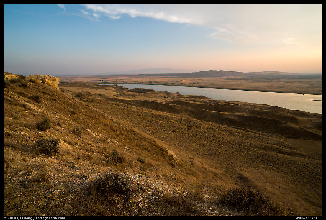
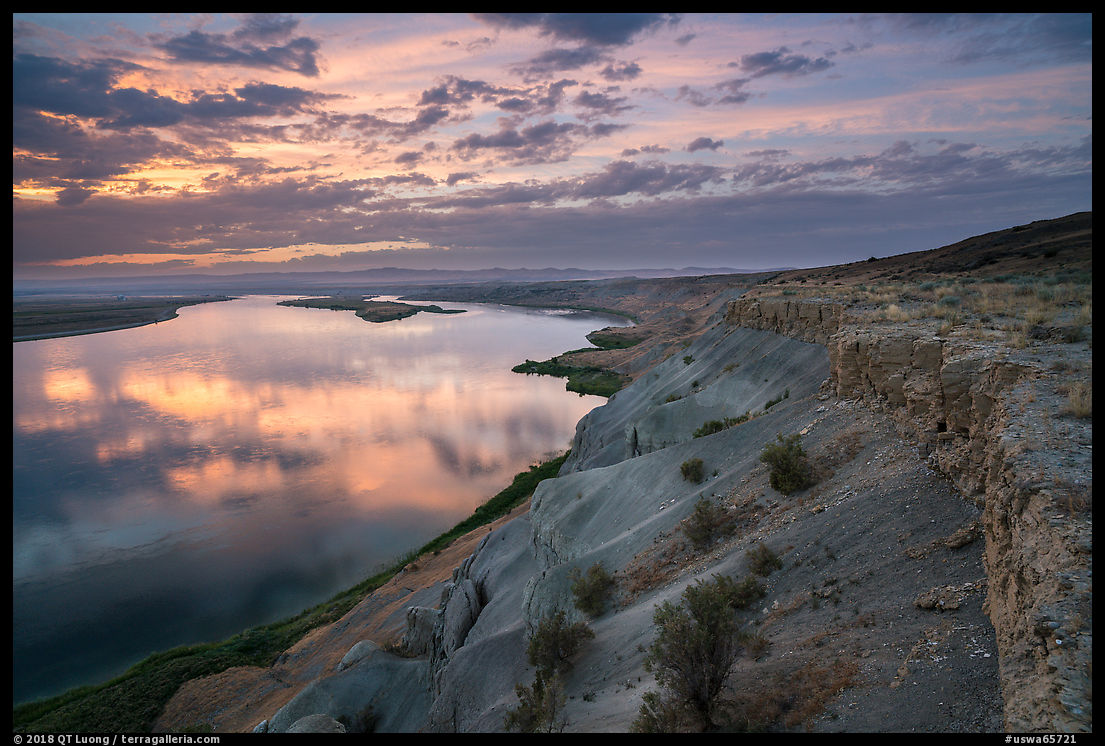
The most remarkable part of the monument is located in the eastern part of the Wahluke Unit, which is accessed via a well-graded dirt road starting south of Milepost 63.2 on Hwy 24. After a few miles, you arrive at an intersection. Heading east, you reach a riparian area called the Wahluke Ponds, which are dominated by tall verdant reeds contrasting contrast with the area’s arid grasslands. Continuing south leads to the White Bluffs Overlook, which offers an excellent roadside view of the Columbia River from the top of the bluffs. The west branch of the road ends at the White Bluffs Boat Launch. The river-level view there isn’t great, but approximately a half-mile mile before the end of the road, there is a large pullout that serves as an informal trailhead. From there, a user trail leads in half a mile to impressive close views of the White Bluffs that tower 400-feet above the river. The White Bluffs face West, so the hike is best undertaken in the late afternoon. The trail then climbs and follows the edge of the cliffs, and about three miles later, ends at extensive sand dunes that you will not find criss-crossed with footprints.


Ringold Unit
The Ringold Unit offers the opportunity to see the Columbia River and the surrounding habitats at river level along its well-graded, unpaved 8 miles, with bluffs and golden hills on the other side. The Ringold Unit is adjacent to the Wahluke Unit, but the 2-mile section of road linking to the White Bluffs Overlook, although open to foot traffic, is closed to vehicles. Driving from one to the other requires quite a big detour.Saddle Mountain Unit
The area is part of the Columbia River Plateau, formed by basalt lava flows and water erosion. That geography is best observed from Saddle Moutain. A road, starting north of milepost 60.1 on Hwy 24 mostly, paved although indicated “high clearance vehicles”, gains about 1,500 feet elevation for excellent views of the Reach. At an intersection, make a right following a sign, the left branch continues for a long distance and eventually descends into the opposite valley. At first, it looks like all rolling hills, but a hike down the saddle from the end of the road reveals large basalt cliffs. I didn’t see a single person on the road or on the off-trail hike to the Saddle Mountain summit, and in the quiet of the place where only the sound of the wind was heard, the nuclear reactors and patches of agricultural lands looked far and insignificant.


Unfortunately, my selection of images is quite limited due to a big data loss, but I still hope that they have offered a glimpse of the beauty found there. I am looking forward to return in the springtime.


It’s nice to see a glimpse of this place! I’m moving to Yakima in about a month, so it’s great to have some inspiration for an area I hope to check out this winter.
Visited the B Reactor site a year ago, it is an amazing monument historically as well as naturally, but I did see a few rattlesnakes while I was there. Sorry that you lost that memory card, but I appreciate the lessons learned.