Basin and Range National Monument Farewell
5 Comments
Days 14, 15
Shooting Gallery
Basin and Range National Monument is located near the south edge of the Great Basin Desert. The detached Shooting Gallery Unit, about 8 miles west of Alamo, is the southernmost section of the monument. It is part of the Mojave Desert, as evidenced by strands of Joshua Trees growing there. The three archeological sites of Basin and Range National Monument have some of the most extensive collections of petroglyphs I saw anywhere. The Shooting Gallery was named so because seasonally abundant water and a good grazing area in the narrow valley of Curtis Canyon made the place one of the few known ancient game drives sites in Nevada. Remarkable petroglyphs are etched on boulders, including many of bighorn sheep and deer in the Great Basin Representational style (A.D. 1-1500). Of the three archeological sites in the monument, the Shooting Gallery is the least visited. The 9-mile Curtis Canyon Road is graded by has two very steep sections. The approach road was more rough, and as the final descent looked questionable, not wanting to take any risks, I parked my SUV at the pass a few hundred yards before the trailhead.I had planned to get up an hour and half before sunrise to try and photograph petroglyph panels at dawn with a bit of artificial lighting like I did in Gold Butte National Monument. However, when I woke up, the sky was no longer dark, and I recognized that the sun would soon rise. Looking at my clock, I couldn’t understand what went wrong. It is only when I drove back to Alamo that I realized that I missed adjusting for the transition back from daylight savings time! I got on the trail in a hurry with the hopes of at least catching the sunrise colors in the sky, but soon it became clear that I would not reach the petroglyphs in time. In retrospect, maybe I had been better off not trying to look for them in the dark. The petroglyphs were more difficult to locate than at the two other sites. They lie half a mile from the trailhead, not along an established trail, and are not marked. I would probably have missed some of the most interesting panels without GPS coordinates. Even with them (from the Rock Art Guide created by Lincoln County NV) it is still possible to miss some if you do not make sure to circle around boulders.


Mt Irish Archeological District
The Mt Irish Archeological District consists of four areas of rhyolite boulders with petroglyphs in a scenic broad valley at the base of the Mt Irish range. The unpaved Logan Canyon Road, starting at a barbed-wire gate 2.5 miles north of Crystal Springs on SR 318, is rough but passable by a passenger car driven carefully. At a junction 6.8 miles out, it continues on the south branch with a BLM sign. A group of boulders forming the smaller Echo Rock site is found 0.1 miles south of the road. 1.7 miles further, the road reaches a boulder pile next to the road and a second BLM sign. This is Paiute Rock, where a trail links 9 markers. I observed different levels of desert varnish at marker #4, indicating a likely large time difference between them. Scatters of chipped and ground-stone led to archeologists concluding that the sites were occupied from 1000 B.C. to the 1860s. A short, rougher spur road 0.3 miles further leads to Shaman Knob (another pile of boulders on the east of the road, 4 markers) and Shaman Hill (on the west, 8 markers) where I found many more petroglyphs by wandering around the boulders. A study of the Shaman Knob area suggests that it was used repeatedly by the hunter-gatherers for camping. I meditated on the relationship between the system of religious beliefs, the rock art and the landscape.


Garden Valley
Garden Valley is one of the two and sage-covered basins entirely contained within the monument. My favorite view was from a rock formation that rises from the valley floor, providing an elevated perspective that helped me behold the vast expanse to the north. That formation consists of a set of volcanic crags located near the southern entrance of Garden Valley, right next to Mail Summit Road, about 25 miles from SR 318.On that trip, I was initially eying the Leviathan Cave, a huge cavern located near a remote mountaintop, but decided against the risk of going there by myself, planning instead to return at a later date with companions. With my schedule lightened, after photographing at sunset, I camped on the flat south of the crags. Since I was going to photograph again from there at sunrise, for the first time in my trip – and also its last night, I had plenty of time to relax and cook an abundant dinner. At sunrise, I hiked further east on the ridge for a higher viewpoint from which I witnessed a great show of light.


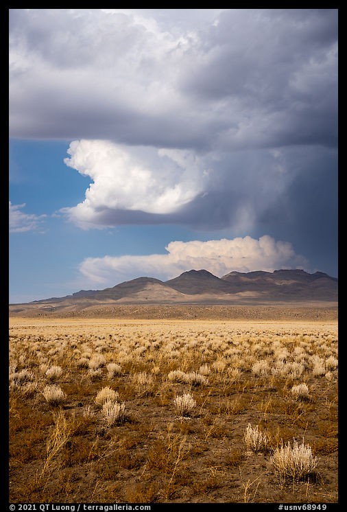
Normally, as the day progresses, the light becomes less interesting, but on that morning, as a storm was approaching, the light kept improving. At Water Gap, it started hailing. I thought that I’d better hurry up and get out of the monument’s unpaved roads before they get too wet. I had initially planned to exit the monument from the west and drive home via Tioga Pass, but instead, I took Seaman Wash Road in the east, as it looked like the fastest way to get back to the pavement. Fortunately, the precipitation stayed moderate. As soon as it began to let down, I stopped and photographed the clearing storm. Placing the horizon line at the bottom emphasized the skies and reduced the prominence of the foreground, which was limited to sage flats.


By that time, it was midday, but the light was beautiful, and I was grateful for this departing gift. Slightly past noon that day, just before leaving Basin and Range National Monument, I made my last landscape photograph of the decade a few yards from the park’s boundary, before embarking on the 10-hour, 675-mile drive home via Las Vegas, arriving just in time for dinner on Election Eve. Presidential candidate Joe Biden had promised to revert President Trump’s attack on our national monuments. The latter had a few beneficial unintended consequences. It reminded us of John Muir’s exhortation that “the battle for conservation will go on endlessly.” It prompted me to set out to see for myself the magnificent landscapes of the parks less traveled.
The Last Road Trip: 1 | 2 | 3 | 4 | 5 | 6 | 7 | 8 | 9 | 10 | 11 | 12


I am so excited to see the book published, this post was quite the teaser! Another monument on the visit list.
Great wok, looking forward to the publication. Inspired to get out and visit these amazing places.
Love the new pics! I’m eager to get the new book when it’s published.
Thanks for the work and for keeping me informed.
Thanks sooo much for sharing your beautiful work QT. Really looking forward to seeing your new book. Will keep it next to my bed just like Treasured Lands.
Thank you Michael, Mark, John, Rick, for your interest in my work. I think it will be a good one!