Zion National Park’s High: Observation Point
No Comments
Zion National Park doesn’t have the equivalent of Yosemite’s Glacier Point. Because of the sheer walls surrounding Zion Canyon, there are only two trails leading from the valley floor to the rim. Although lesser known than Angels Landing, the Observation Point Trail is the higher of the two.
Angels Landing Trail is is famous for having exposed sections, protected by chains and guardrails. The steep 5-mile round-trip hike with a 1,500-foot elevation gain ends on a narrow spine that climbs a finlike mountain jutting out to the center of Zion Canyon from the West Rim.
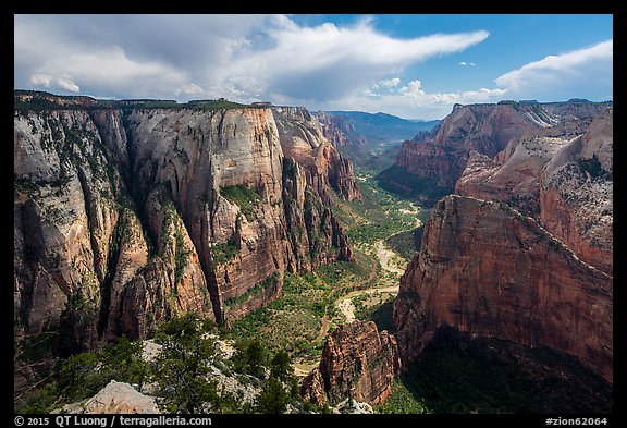
The Observation Point Trail is a bit longer (8 miles round-trip; 2,100-foot elevation gain) leading to an even higher view of the canyon than Angels Landing, which appears as a small ridge (backlit in image above) from there. On the way, I took in a good variety of scenery, including the dark Echo Canyon, with beautiful slick rock formations and a glimpse into a slot canyon at mile 2.

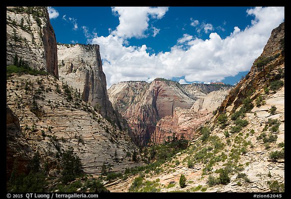
Past that section, views open up over a secondary canyon not visible from the Zion Canyon floor. Then the last section of the trail is a long, level traverse along the rim, which offer a variety of angles that enable you adjust the viewpoint over Zion Canyon depending on the angle of light. I liked the views along the initial section of the traverse in the morning. In the afternoon, the light was more favorable at Observation Point itself.
For the iconic shot looking down Zion Canyon, light is difficult on a clear day. Too early or late in the day, the canyon is in the shade, whereas at midday, the view is backlit. With normal hiking hours, the best is early morning or late afternoon, when one wall is in the shade, but the valley is still illuminated. The more northerly angle of the sun in the summer months helps, as will clouds.
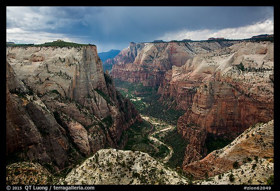
On a cloudless day, the soft and directional light of dawn or dusk would be ideal. However, during the mandatory shuttle season (March to early November, plus November week-ends) you cannot park at the trailhead and either the first shuttle would be too late or you’d miss the last shuttle. Alternatively, you could hike from the Zion Ponderosa Ranch Resort via the East Mesa Trail (which is used to access Mystery Canyon). The trail is about 7 miles RT, with little elevation gain, but much less varied than hiking from the canyon since you’ll be most of the time on a forested plateau.
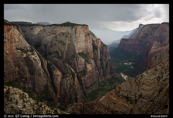
On that June day, the initial plan was to descend the Subway from the top. However, the weather was threatening, and we changed our plans. I thought that changing weather may be promising for Observation Point, even at midday. Although I started the hike from the canyon on a warm summer day, at midday temperatures suddenly plummeted. I barely had time to put my camera gear away when a thunderstorm brought hail to the rim. Half an hour earlier, I was sweating profusely despite using my umbrella for shade. During the storm, despite wearing a rain jacket, I felt chilled. I was glad to have something else than a T-shirt, a lesson learned from previous outings! I waited out the storm, huddled under the umbrella that proved again its versatility, keeping me perfectly dry. Afterwards, breaking clouds put out the quickly changing display of light that I had hoped for, with dark clouds creating a brooding atmosphere.

