Treasured Lands Third Edition
2 Comments
The third edition of Treasured Lands has just arrived (order your copy). Although differences are not as many as between the first and the second edition, they were still enough for my distributor to request a new edition rather than another printing – overall the seventh.
The New River Gorge chapter
The main difference is the addition of a new chapter for New River Gorge National Park and Preserve, the 63rd national park. In a previous series of posts, I discussed at length the selection of the main image of that chapter using input from readers. As nice as individual pictures are, they feel short in telling a story about a place when compared to a series of images. A series is not only a carefully selected set of images, it also has a sequence where the order of the photographs contributes to their meaning. One of the reasons why books are such a great medium to present photography is that they lend themselves naturally to sequencing and grouping images.
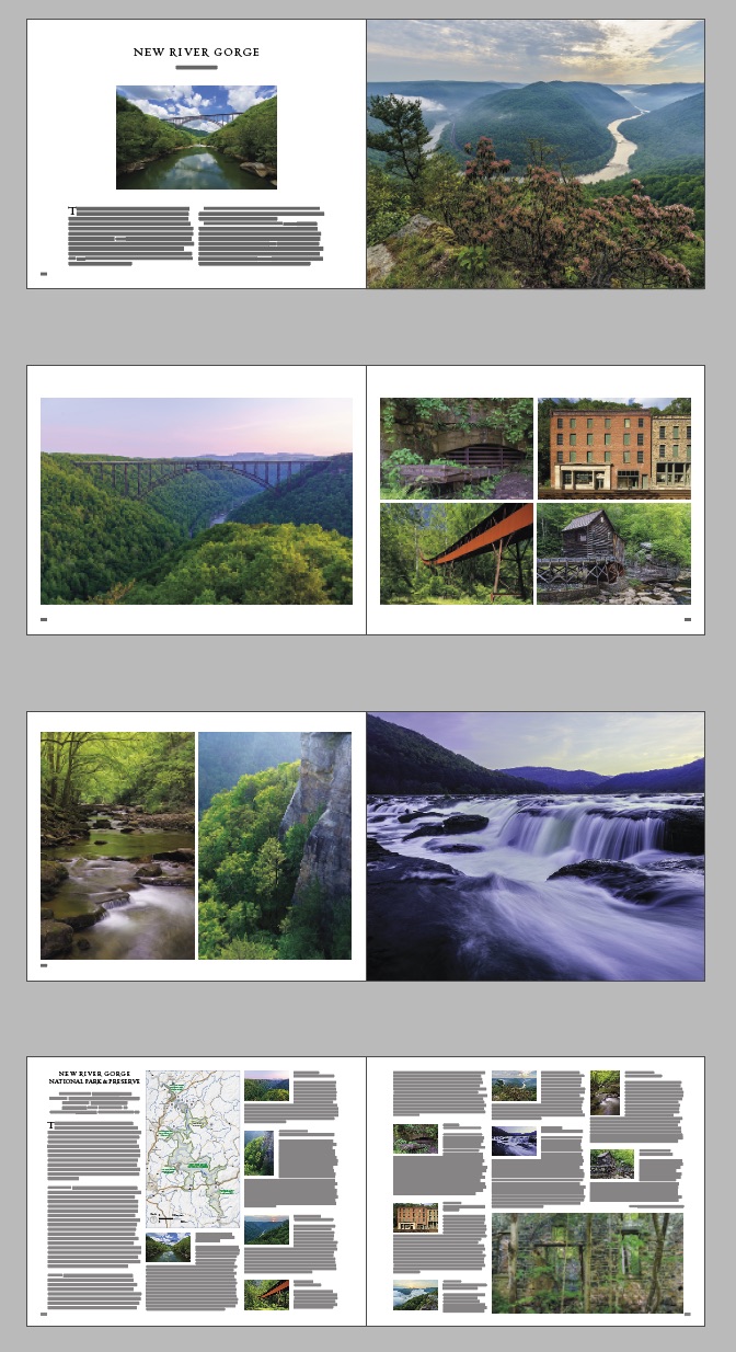
The way the eleven images were chosen, besides their individual merit, is that each of them had to represent one of the eleven locations that I selected to be representative of the park. They also had to complement each other on the page, so that quite a few constraints to satisfy.
Treasured Lands obviously doesn’t have the same ambition as The Americans, but still, I put thought in sequencing images. Here are some of the considerations I took into account to organize the four spreads of the new chapter.
- The chapter opens with three images that are each of a different size, photographed at three different times of the day (midday, midmorning, dawn), and show the gorge from three levels: river, rim, and intermediate mid-valley.
- The first spread signals a scenic park with significant human history artifacts. Even in the river bend view, a railroad is visible. It contributed much to opening this region in the 19th century and is one of only few active railroads within a national park. The first image is a roadside view, the second a short stroll to an overlook. The format of the opening spread is identical for each park. It is important to maintain consistency for those things through a book.
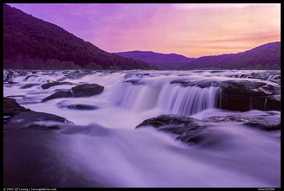
- The second spread is about the human footprint in the gorge. It juxtaposes historic and modern structures – the New River Gorge Bridge was built in 1974. In the grid of four, the upper rows include rails small (a coal cart at Keymoor) and large (the railway curiously close to the facades of Thurmond), the lower row includes conveying devices long (the 1,400-foot Nattalbug conveyor) and short (the water flume of the Gristmill in Babcock State Park). Locations here are a mix of roadside and hiking. The left column shows structures related to mining – the main historic activity in the area, the right column shows the facade of buildings that are not mining structures. From a design point of view, I placed the two more colorful images diagonally, with the swath of red from the conveyor linking them. On any spread, the right page catches more attention than the left one, so I put the more intricate content there. Wanting to emphasize the similarity in the subjects rather than their contrasts, I aligned the left image with the grid on the right rather than making it a full bleed.
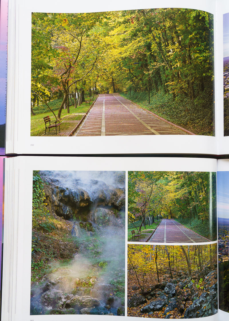
- In the third spread, we immerse ourselves into nature, without a trace of man, and we get deeper in the park. Unlike for the initial spread, those are more concealed locations, and getting there requires more hiking. Because of the diagonals and position of the greens at opposite positions, the two vertical images complement each other. Their quietness contrasts with the spectacular sight of Sandstone Falls, amplified by the full-bleed presentation. Although as a standalone image I liked the sunset version of Sandstone Falls (below), the color clashed too much with the greens, so I chose this more muted version. Since the full page image was previously on the left, it was natural to move it back to the right for variety.
- Last, my favorite image of Kaymoor was of the forest reclaiming the powerhouse in an eerily evocative ghost town. For the conceptual symmetry mentioned above, I used the image of the coal cart in the grid of four instead. I snuck that image in the information page to complete the cycle of natural and man-made.
More data
The information spread for each park opens with data about that park. I’ve added three pieces of data that quickly convey significant information.- For areas that received protections before being designated a national park, some argue that the date when they first received protections is more significant than the date when they were (re) designated a national park. When applicable, I now provide both: the initial establishment year and initial name are listed in addition to the year of designation as a national park. For instance, for White Sands National Park, that line reads “Established: 1933 (National Monument), 2019” meaning that the area was first protected as White Sands National Monument in 1933 and became White Sands National Park in 2019. Besides being a small piece of history, it is a useful reminder of the central role of the Antiquities Act in American conservation: about half of our national parks started as national monuments.
- Each park is located in relation with a nearby city to help pinpoint it at a glance and also indicate the closest major airport. All the cities have international airports except Jackson WY, even though the Jackson Hole Airport is the busiest in Wyoming – it has the distinction of being the only airport inside a national park.
- The highest point in each park, and its elevation are listed. Elevation varies wildly between parks, with the three highest in Alaska (Denali, Wrangell-St Elias, Glacier Bay; resp. 20,310 feet, 18,008 feet, 15,300 feet) and the three lowest in Florida (Biscayne, Dry Tortugas, Everglades; resp. 9 feet, 10 feet, 20 feet).
Other minor changes
I’ve tried to keep the information in the book current. As record-setting numbers of people continue to visit our parks, crowded conditions have led to a degraded visitor experience, including traffic jams, overflowing parking lots, and some people even turned away at entrance gates. Among other updates, it is mentioned in the relevant chapters that some of the popular parks have started requesting reservations for entry, for instance:- Yosemite National Park. From late May to September, a day-use reservation or lodging/camping booking is required for entry.
- Glacier National Park. A reservation or service booking is required to drive Going-to-the-Sun Road from 6 am to 5 pm in the summer.
- Rocky Mountain National Park. From late May to mid-October, entry from 9 am to 3 pm requires a reservation. For the Bear Lake area, from late May to Mid-October, a specific reservation is required from 5 am to 6 pm.
- Acadia National Park. From late May to late October, a reservation is required to drive the Cadillac Summit Road from 4 am to 8 pm.
One thing that hasn’t changed is the price. The inflation calculator indicates that an item costing $65 in 2016 (first edition of Treasured Lands) costs $78 in 2022. The book has gone from 456 pages to 492 pages, a 8% increase, so that would be $85. Largely due to Covid, the cost of shipping a container from Asia to the U.S. warehouse have increased from less than $7,000 to more than $24,000. Even in 2016, Treasured Lands was an incredible value compared to other photography books. The price remains $65, a bargain for readers, but clearly not sustainable. If you haven’t done so yet, get the book at a great price before the inevitable increase!


A reviewer on Amazon for the 3rd edition reports that the copy they received has pages out of order. Is there a problem with this printing or was that just a fluke?
It is a fluke. I will elaborate in a separate post. Both Amazon and I will replace defective copies at no charge.