Mojave Trails National Monument Highlights
No Comments
Protecting a huge 2,500 square miles (1.6 million acres), Mojave Trails National Monument is the largest of the three California desert national monuments established by President Barack Obama in February 2016, and also the second largest national monument in the contiguous U.S. or the largest if you count the reduction in size of Grand Staircase Escalante National Monument. In the heart of the California desert, Mojave Trails National Monument forms a connective tissue linking Joshua Tree National Park in the south to Mojave National Preserve, that it surrounds and with which it shares many geological features: remnants of a volcanic past, isolated sand dunes, and rugged mountain ranges.

(click on map for larger version)
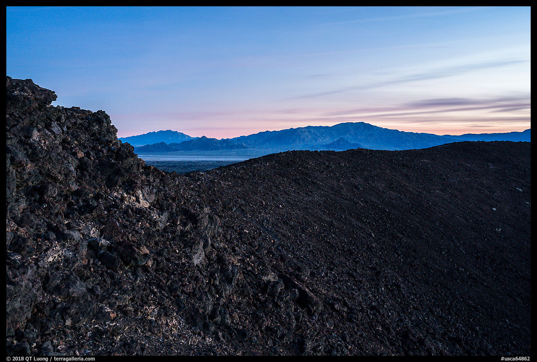
Amboy Crater
Amboy Crater is a cinder cone extinct volcano whose black color sharply contrasts with the earth tones of the surrounding desert. It is perhaps the most easily accessed and developed area in Mojave Trails National Monument. Amboy crater was a popular sight for travelers in the heydays of route 66 from the 1920s to the 1960s. On my recent visit, I encountered hikers both at sunrise and sunset. From the trailhead and the approach, Amboy Crater is front-lit in the morning.


A newly paved spur road on the south side of Highway 66, about 2 miles west of Amboy (population 4) leads to a nice picnic area which serves as a trailhead. The hike is about 3 miles RT. Although from a distance the area looks flat, the trail first crosses labyrinthine lava fields and sandy washes and required a bit of attention to follow. Returning in the dark after sunset, I was glad for the discrete, but frequent markers. Once you reach the cinder cone on its western side, it becomes rocky and steep as you walk on lava blocks to climb 250 feet to the crater rim. A 0.3 mile-mile trail circles the crater top, offering a great perspective of itself and of the desert extending to distant mountain ranges beyond. I waited for the soft and even light of dusk to photograph the textures within the crater, while delicate colors lingered in the sky, although there was hardly enough light to see.

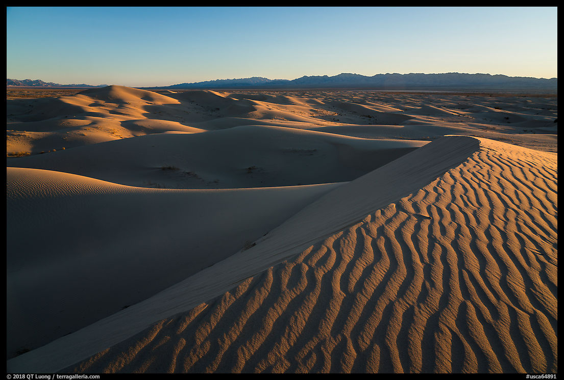
Cadiz Dunes
By contrast, the Cadiz Dunes are one of the most remote highlights of Mojave Trails National Monument. If it wasn’t for a rendezvous with photographer Greg Russel, who wrote an excellent post about threats to the area’s water, I wouldn’t have seen a single other person since leaving the pavement in the afternoon. The dunes are surrounded by mountains, and light is good both at sunrise and sunset. I preferred to photograph slightly backlit to emphasize the play of light and shadows.


The dunes are located in the Cadiz Dunes Wilderness and were not heavily used by off-road vehicles prior to their protection by the California Desert Protection Act of 1994, so they are still pristine. Besides having them to ourselves, we did not see any human footprints, although animal tracks were plenty. Getting there requires driving the Cadiz Road, which is unpaved but passable by most vehicles. From Highway 66 in the north, the road is slightly rougher than from Highway 62 in the south, with a few washed-out sections, but that is more than made up for by the fact that the unpaved drive is only about twice as short. From Cadiz Road, a 2.5-mile access road situated on the northwest edge of the dunes leads to a small parking area right next to the dunes. The last mile of that access road is sandy, fortunately the sand was firm enough that my AWD Subaru Forester had no trouble. I made sure not to slow down until I reached the parking area – which is hard enough that it was safe to stop on.


Afton Canyon
Although water is present under the desert ground, there is only one place where the 140-mile long Mojave River continuously flows above the ground rather than under the sands. Besides the rich desert riparian habitat of willows, Afton Canyon has also steep rock walls that earned it the nickname of “Grand Canyon of the Mojave”.


While staying at the campground reached via a few miles of well-graded unpaved road from I-40, trains ran fairly close all night, but fortunately they slowed down through the canyon enough that closed car windows muffled much of the noise. I was hoping to travel the whole length of the canyon by car, but right after the campground, the Mojave River flows onto the road, requiring a long crossing. After measuring a depth of at least 18 inches, I decided not to risk it this time.


Update: I returned to Afton Canyon a year later with a more capable vehicle.
Route 66
Historic Route 66 is a quintessential American icon of a bygone period, and Mojave Trails National Monument includes 105 miles of it, from Needles to Ludlow. This represents the longest remaining undeveloped stretch of Route 66. During my visit, a long section of it was closed for bridge repairs, and the total absence of traffic made it possible for me to set up long exposure night shots.


Mojave Trails National Monument is so recent that facilities are still minimal, and in particular you won’t find a visitor center. Nevertheless, I am hoping those highlights can get you started. In such a huge desert area, you are sure to make plenty of discoveries out of the beaten path!
See more images from Mojave Trails National Monument
Part 1 of 5. 1 | 2 | 3 | 4 | 5

