Cascade Siskiyou Beyond Pilot Rock
3 Comments
Most travelers identify Cascade Siskiyou National Monument with Pilot Rock, whose distinctive profile can be seen from both directions of I-5 between Oregon and California. In this article, I describe four other favorite locations in the monument and discuss some of the photographs I made there. Except for the last one, all of them require a bit of hiking. Because Cascade Siskiyou National Monument is heavily forested and all below treeline, there are not too many roadside views in the monument. Pilot Rock is not forgotten, though, as it is seen from all over the monument, and it will serve to link those locations, kind of like in Hokusai’s 36 views.

(this is the best available map, click to enlarge)
Boccard Point
Boccard Point, in the Soda Mountain Wilderness at the south of the monument, is a bluff located in juniper scablands that offered the best views that I found within the monument. I thought they were spectacular than Pilot Rock because at Pilot Rock, when you are at the base, views are limited by the rock, while the top of the rock is quite narrow, therefore not offering a range of viewpoints. On the other hand, the last quarter-mile of the trail to Boccard Point follows a ridge with open views. This lets you choose from a range of different foregrounds to the expansive views that include the three mountain ranges converging in Cascade Siskiyou National Monument.The main trail from the Hobart Bluff Trailhead, is 10-mile (RT) with 1,500 feet elevation gain. In 2014, the Siskiyou Mountain Club cut a new trail into an old road from the Pacific Crest Trail (PCT) to Boccard Point. It remains quite primitive with faint and rough sections, but reduces the hike to 4 miles RT. That trail was recent enough that Ashland-based noted photographer and educator Sean Bagshaw, with whom I had the pleasure to hike, had not been there yet. To get to the trailhead from Hwy 66, take Buckhorn Springs Road (unpaved from there, but easily passable like most roads in the monument), Tyler Creek Road, then Baldy Creek Rood until you see a small parking area on the left crossed by the Pacific Crest Trail (PCT), and look for a faint path heading east. Boccard Point is marked on the official map, but is a quiet destination. I saw a party on the PCT, but we had the rest of the trail to ourselves.

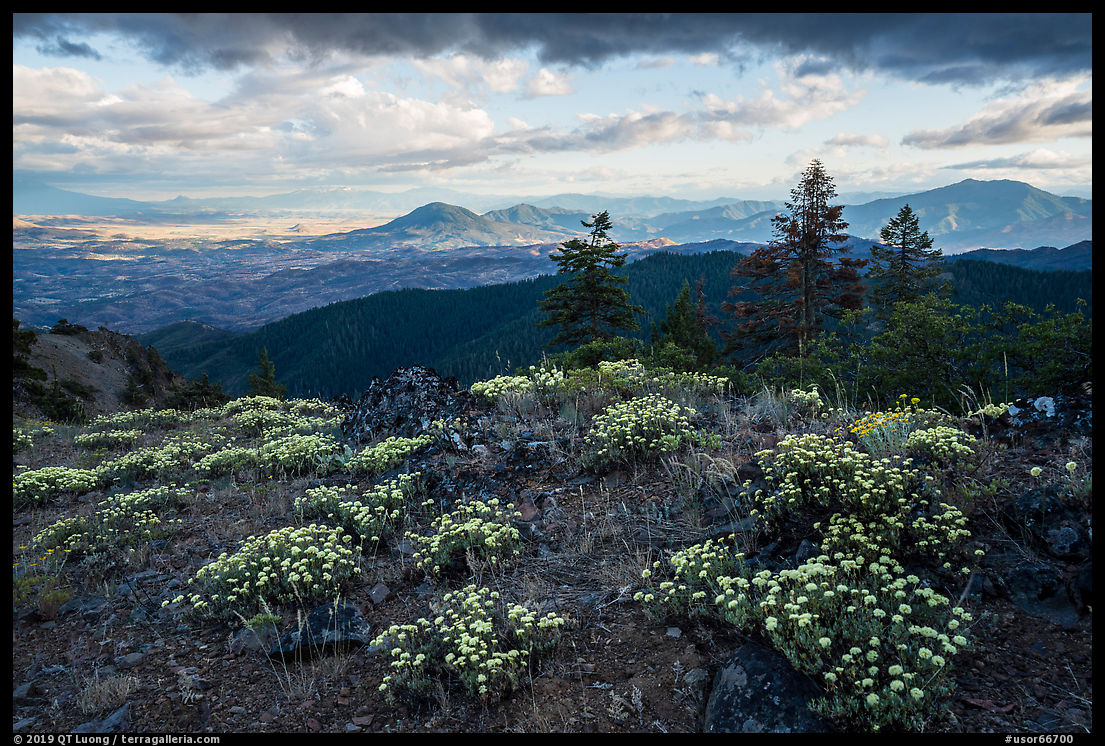

Hobbart Bluff
Hobart Bluff Trailhead gives access to two moderate trails. The Soda Mountain Lookout (4 miles RT) offers views that extend to Pilot Rock and Mount Shasta, but the last mile is a bit of a trudge on an old road and the summit itself is uninspiring because it is full of structures and communications equipment. My favorite part of that hike was the first mile on the PCT where in late June wildflowers abound in the meadows. After making the wide view in sunny conditions, I waited for a passing cloud to photograph a more intimate view of the meadow excluding the sky without the distractions created by shadows and high contrast.


Hobart Bluff is a 3-mile RT hike with 240 feet elevation gain passing old-growth forest and rolling meadows along the way. The views to the north open far. I did not want a highly magnified foreground to compete for attention and scale with the sunrays, so I composed with the wildflowers at some distance, and similarly I felt that a distant foreground balanced the hills better.


To the south, the views are limited by a ridge and the presence of a power line. Photographing in that direction, I made my composition about the contrast between the chaotic foreground and the regular pattern of conifers.

Grizzly Peak
Cascade Siskiyou National Monument, as proclaimed by President Clinton in 2000, initially covered 65,000 acres. At the urging of scientists, in 2017 President Obama extended the monument by 48,000 acres. Grizzly Peak and the surrounding Rogue Valley foothills in the northwest corner of the expansion area are home to rare populations of plant species such as rock buckwheat, Baker’s globemallow, and tall bugbane. I wouldn’t be able to identify those, but I delighted in some of the more than 275 species of flowering plants found there. The Grizzly Park Loop Trail is a favorite hike for locals. The lollipop loop (5 miles, 840 feet elevation gain) leads to to big views, all the more open because the forest near the top burned. By hiking counter-clockwise, you save the best views for last.


Before passing some of the most beautiful meadows I’ve seen in the monument, the trail starts in the forest. Right at the start of the trail, in the afternoon, a backlit tree on a hillside caught my eye. It appears small in the high-contrast composition but that is precisely why it brings more depth to it. The next morning, before sunrise, the exact same scene looked entirely different as the soft, but directional light revealed the deep palette of greens, the forest’s texture, and the lush forest floor.


Hyatt Lake
Unlike several of the primitive national monuments I wrote about recently, Cascade Siskiyou is quite close to a city (Ashland), and has reasonable amenities that include restrooms, well-signed trails and trailheads. At the hamlet of Green Springs, near the intersection of Hwy 66 and East Hyatt Lake Rd, there is an information station where you can pick up a useful free map, and a lodge with a restaurant. You could also stay at a fully developed campground on the shore of Hyatt Lake. Other free primitive campgrounds are available, and like in most BLM-managed national monuments, dispersed camping is also allowed.When I came to the Hyatt Lake lakeshore in the afternoon, the wind churned the water. This eliminates any reflections, and makes the water look darker. Returning the next day in the early early morning, I found the water glassy as I hoped, and as a bonus a thin layer of fog rose at one spot in the lake. I promptly made my way around the lake to head closer to it.


My first instinct was to exclude the sky to keep the focus on the band of light formed by the fog, with the dark band of trees keeping the eye in the picture. However, I also liked that the sun and the rock seemed to be in dialog with each other. I stopped down the lens to f/22 to make a sun star and tried a wide view from the same viewpoint, framing the image so that the line formed by the shore would originate in the right bottom corner of the image and remain clear from the image frame. Since what attracted me to the wider composition was the balance between the sun and the rock, I made it stronger by moving the camera to align them vertically. The shallow arm of water was now vertical rather than oblique, so we have also the bright vertical line of the sun reflection balance the horizontal bright line formed by the fog. Do you think the small change of viewpoint made a difference?


Thanks for your interesting blog comments.
Yes, I think your slight adjustment makes a big difference in the composition.
Next time you are in the area I can show you another hike to Joe’s Rock that has a short bushwhack to get to. Jenny Creek has some nice areas too.
Fun stuff.
I am looking for the way to Joe’s Rock (I think ) from 39-2E-34. Do you have coordinates or instructions, or a gpx track?
Thanks for the ideas, would be fun to meet!