Upper Missouri River Breaks National Monument’s accessible spot
2 Comments
The longest river in North America, the Missouri River flows for 2,341 miles from Western Montana to St Louis, where it joins the Mississippi River. In 1976, a 149-mile section of the Missouri River in Montana was one of the first river segments to be protected with the Wild and Scenic River designation. Lewis and Clark of the Corps of Discovery traveled this part of the Missouri River during their expedition in 1805. Besides some cattle grazing, it remains much the same as it was back when they passed through. Upper Missouri River Breaks National Monument protects that last free-flowing section of the Missouri River and 375,000 acres of surrounding plains, bluffs, cliffs, and badlands. The word “Breaks” is a geographical reference that describes those rugged landforms eroding (“breaking away”) from uplands to the river bed below.

The monument stretches for about 90 miles from Fort Benton in the west to the Charles M. Russell National Wildlife Refuge to the east, with the river meandering for 149 miles. Many campgrounds, both primitive and developed, are situated on the riverbanks. Those located at each of the landings previously mentioned are developed and accessible by road. The closest towns with travel amenities are Winifred to the south and Fort Benton to the west. The later, more historic and touristy, is in the monument. It is home to the Missouri Breaks Interpretive Center where you can obtain trip planning information, and to Missouri River Outfitters who provides boat rentals, shuttles, and guided trips on the river. There is also a bed and breakfast in the historic settlement of Virgelle, close to Coal Banks Landing.

(click on map to enlarge)
Naturally, the monument is best seen by paddling a canoe or kayak down the river, this will be the subject of a subsequent article. Most places of interest are very difficult to access without floating. Roads to them can be very rough and become impassable during wet weather because they are made of clay. They also traverse private lands, requiring landowner permission to access. However, besides the landings, there are a few places of interest that are accessible by road, and this article is about the most easily accessible of all. If you don’t have much time and want a glimpse of the monument without floating or significant driving on dirt roads, that would be the spot. Although it appears modest, there is much to photograph there.

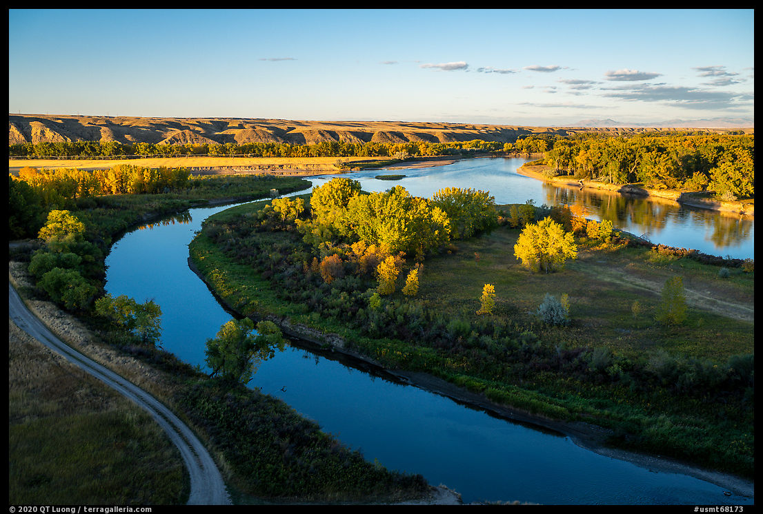
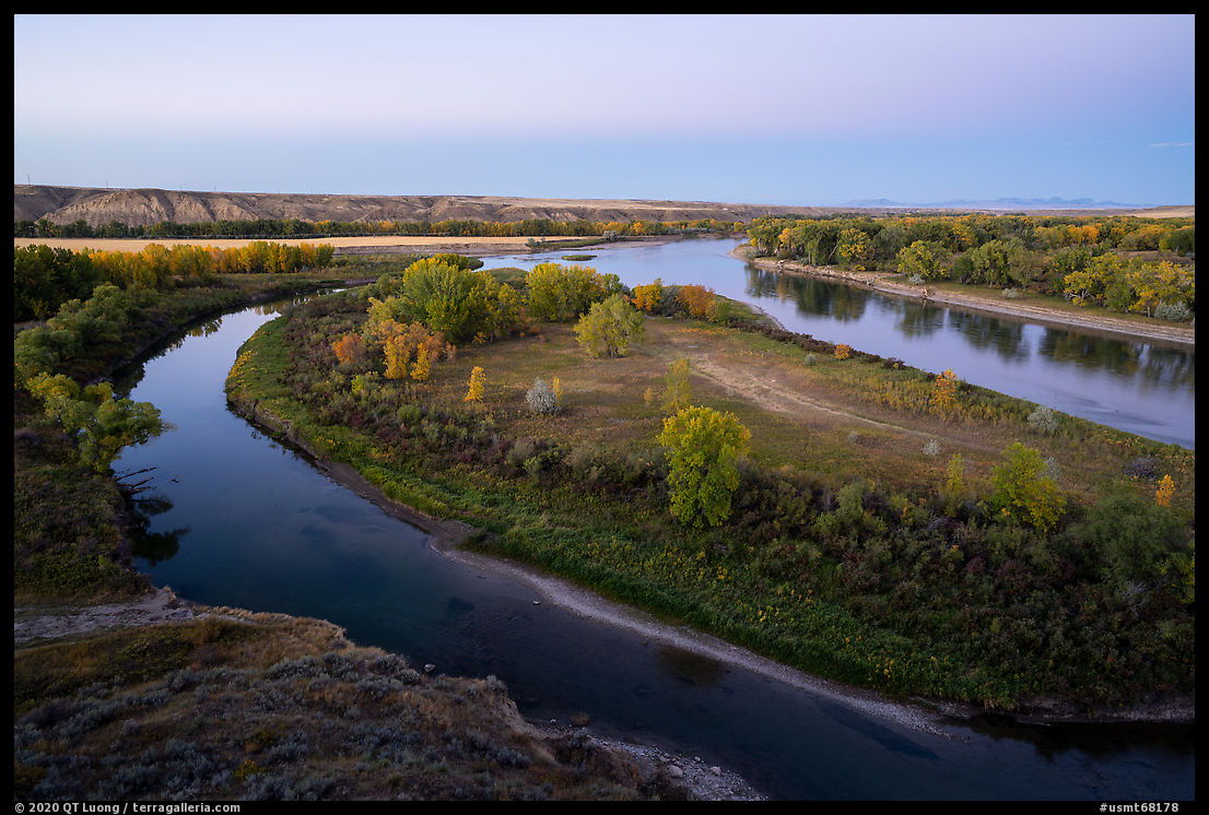
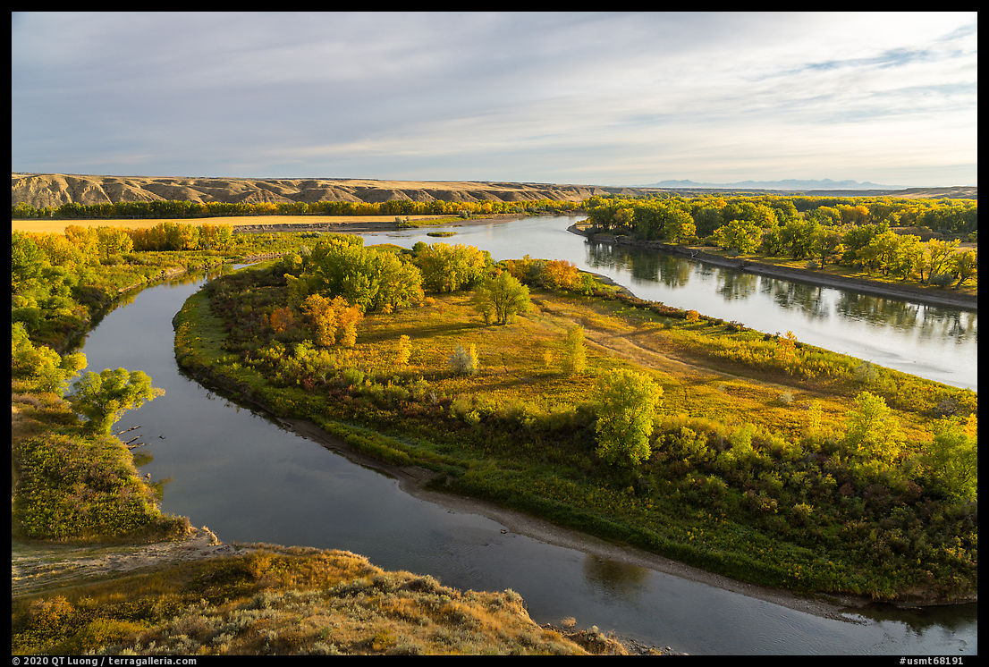
Decision Point
Traveling upstream, the Lewis and Clark Expedition stayed for 10 days at this site, at the confluence of the two rivers, trying to determine which one may lead them towards the Pacific Coast. They made the correct decision to follow the south fork, which is the Missouri River, naming the north fork the Marias River. Along the Loma Bridge Road, a 0.25-mile interpretive loop trail tops a bluff with excellent high views of the confluence and a river island. Despite the proximity of the small town of Loma which is within eyesight, the area has retained a peaceful pastoral character.In landscape photography, timing is often essential. Here’s how my timing at Decision Point turned out. Mid-morning of the day of my evening visit there, I started from Wapi Park in Idaho, about 500 miles away, including some pretty rough roads – just driving the 70-mile Arco Minidoka Road can take all day. Upon exiting the I-15 at Great Falls, although the car’s dashboard showed I would reach Loma with about 50 miles of gas left, I decided to spend maybe 10 minutes for a gas stop. It turned out I arrived about 10 minutes late at the top of the bluff for the “late afternoon” light. On that day, the sunset was at 6:11 PM, and I had gotten there at 5:35 PM. However, as often is the case, a hill was blocking the light, throwing large parts of the scene in the shade. In doubt, it is preferable to plan to photograph with the sun not too low on the horizon. When shooting towards the east, the light of sunset is generally reliable: the excessive contrast is gone, and a band of color in the sky enlivens the horizon, however the lack of directionality makes it a bit flat. Past sunset time, the directionality comes back in delightfully soft light, but the color of the sky is gone. The main view (another is above) is towards the north-east. Because of that, I had come at sunset when it would be mostly front-lit. At sunrise, it is slightly backlit. I returned the next day in the early morning because you never know. The backlight made the sky is a bit bright, but the light on the land and trees was beautiful.


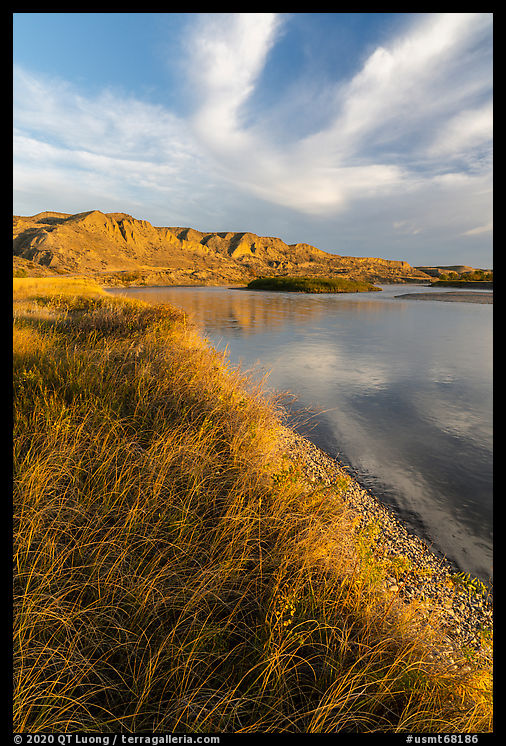
Wood Bottom
Just north of the Loma Bridge over the Missouri River, a 0.7-mile road leads to the Wood Bottom Developed Public Access Site (river mile 20.3). It is the first developed campground and boat launch after leaving Fort Benton. The float to or from there is often arranged as a day excursion. Both roads are surfaced with gravel, making them accessible in all weather. After photographing at Decision Point until dark, I initially tried to get to the Wood Bottom campground using Google Maps, but this didn’t work as the app pointed to a road at the top of the bluffs, leaving me quite perplexed as despite “you have arrived”, I struggled to make out anything in the dark. I located the correct road using a detailed BLM map.The site is located at the base of tall bluffs that catch the first light of sunrise. It offered nice river-level views, but in the immediate vicinity of the campground, I struggled to find spots where a footpath along the edge of shore wasn’t too visible. As the light was progressing, I tried to hide it behind grasses, then excluded it from the composition, but eventually by walking a distance, I was able to find a more pristine spot that allowed me to include more of the shoreline.


More images of Upper Missouri River Breaks National Monument Part 1 of 3: 1 | 2 | 3


Cool … this place was not on my radar screen but I’ll have to put it on the itinerary if and when I next get to Montana …
The landscape of prairies, bluffs, sheer cliffs and badlands surrounding the river are quite unique. A few years back, I heard about them from Dayton Duncan – the writer of a film/book about Lewis and Clark. The Zinke review had the benefit of pushing me to explore them.