Sonoran Desert National Monument Guide: Part 2
5 Comments
Part 2 of 5: 1 | 2 | 3 | 4 | 5
Although quite obscure in the big scheme of things, the locations in Sonoran Desert National Monument that we visited in the first part of the article are the most obvious because they are along the monument’s designated trails. Those trails predate the monument and ironically, their presence means that the corresponding wildernesses, North Maricopa Mountains and Table Mountains, have more development and visitation than the rest of the monument. Outside of the wildernesses, there are plenty of other lands where one can explore by wheels and on foot, and find even more solitude.
Vekol Valley
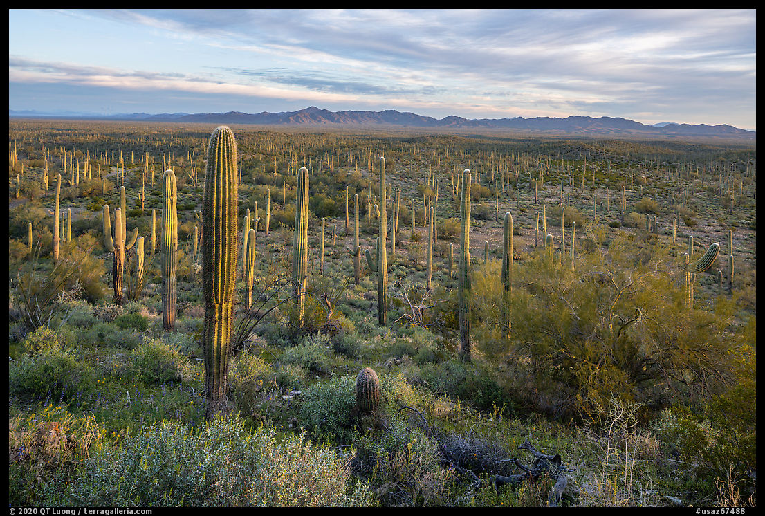
Sonoran Desert National Monument is bisected by I-8. While you cannot stop along the interstate, there are a few exits that deserve the southern part of the monument. I’ve mentioned the main access point at Exit 144 to the Vekol Valley Road. Vekol Valley is a strikingly large flat plain full of cactus. To appreciate its size, one needs a higher viewpoint. While Table Top Mountain is high, it is separated from Vekol Valley via foothills and therefore distant. On the other hand, there are smaller peaks that rise directly from the plain. The most easy to access is Lost Horse Peak. Although it is quite prominent from I-8, from there it appears like any other hill. However, when I studied the map, I realized its remarkable position. To find it, take Exit 140, Freeman Road, and turn east, following a short section of road paralleling I-8, looking towards the south for a prominent hill. The only trails in Sonoran Desert National Monument are the four ones mentioned previously. There is no trail to Lost Horse Peak, but it is an easy hike across a wash and then flat desert for less than a mile, and then a moderate scramble to the top. The elevation gain is only about 300 feet, but since you are overlooking directly the plain, the perspective is spectacular.Starting my hike in the late afternoon, I chose to make my way up the peak on its west side so that I could photograph the desert plants in backlight. I stopped down the lens to f/22 to create a sunstar as the sun came to the edge of a cloud. As I got higher, the view of the plain and its cactus opened up, and in my compositions I began to give it more weight. The summit offers a great 360 panorama. I had planned to arrive there half an hour before sunset, but the compositions that I found on my way up made me late, and I was barely able to photograph the eastern side before the light faded away. Naturally, it was dark by the time I got back to my car, but since Freeman Road is only half-a-mile from I-8, the spot was too noisy for my taste, and I drove back towards the Sand Tank Mountains.


Sand Tank Mountains
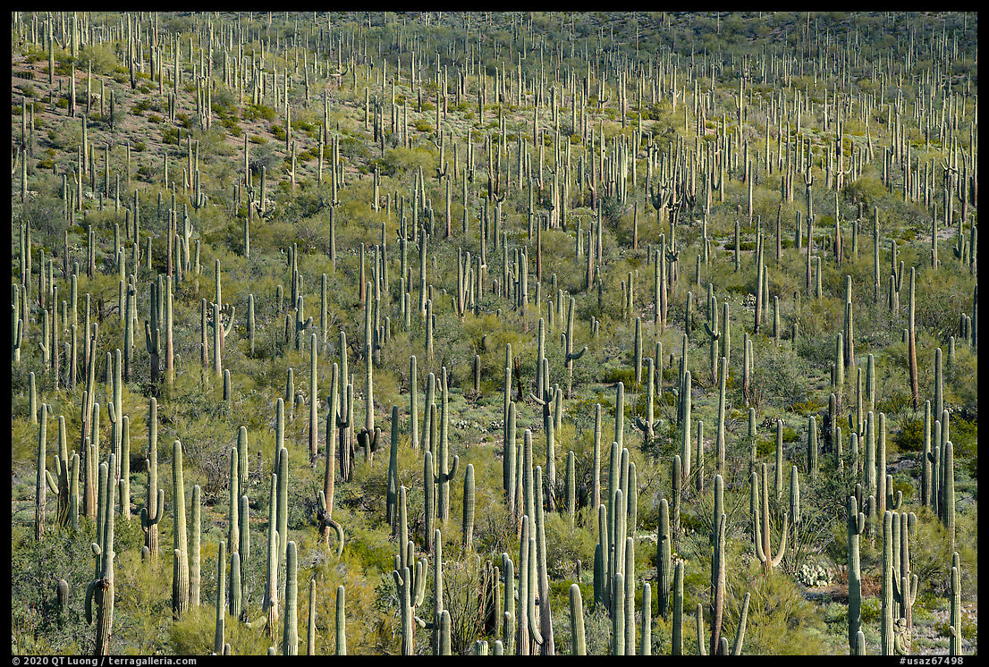
Typically, national monuments are open for grazing. Sonoran Desert National Monument is unique in that its proclamation stated that grazing south of I-8 was not compatible with the preservation of its features. Unlike in other places, the fences that you see around the monuments are meant to keep the cattle out. However, it is only relatively recently that the grazing permits were revoked by the BLM. On the other hand, the Barry M. Goldwater Air Force Range, the third largest military reservation in the United States, used exclusively for air combat training including bombing, was established in 1941. The south-west corner of Sonoran Desert National Monument is part of the Barry M. Goldwater Range. With the area withdrawn from ground activities, its vegetation has not suffered from grazing. Access to that part of the national monument requires a permit, but fortunately, it can be conveniently obtained online automatically via luke.isportsman.net (the former name of the range was “Luke”) by filling in a form and watching an orientation video.The great landscape photographer Jack Dykinga had tipped me about the Sand Tank Mountains, and suggested that I enter through a gate 4 miles west of the Freeman Road Exit, recognizable with an abandoned gas station, marked as “Big Horn Station” on the map. In more urban areas, you would not even be thinking about crossing an interstate highway, but here, just opposite the gate, the divider is interrupted by a paved section just for that purpose. The gate is closed, but unlocked. I gave access to a road quite rough that definitively required high clearance, and narrow enough that there was no place to pull out. Guessing that nobody would come at night, I parked the car at a road intersection, where there would be space for another vehicle to get by, and even though the sky was a bit cloudy, diminishing the visibility of the stars, I took advantage of the total lack of light pollution towards the south to set up a time-lapse.
With daylight the next morning, I saw how dense the Saguaro cactus forest was. Those cactus typical of the Sonoran Desert are omminpresent in Sonoran Desert National Monument and rival the forests in Saguaro National Park. I scrambled up a small hill to depict their extent. For the wide-angle views, I shifted the 24mm TSE lens to preserve the parallelism of the columnar cactus. While the same effect can nowadays be achieved in processing, it results in a significant loss of resolution, since you have to frame very loosely to account for the image areas that are lost when applying perspective corrections. That is assuming that you are able to previsualize a satisfying composition this way. It was difficult to find spots to walk without stepping on plants or flowers. Due to the lack of grazing, the vegetation was significantly more diverse and dense than elsewhere in the monument. In the moments when clouds would reduce the contrast, I switched from photographing wide landscape to close-ups. Further south, the road degraded, and since I was driving a compact AWD SUV in a very remote place, I turned back, but was still grateful to have gotten a glimpse of this beautiful area.


Part 2 of 5: 1 | 2 | 3 | 4 | 5


Thanks for sharing your story and wonderful photos. Maybe one day I’ll get a chance to visit this area.
Awesome…Loved the article and the images….The Sunstar image with the foliage spreading its fronds stretched towards the sun catching the glinting rays is exquisite…
Thanks! I assume you were referring to the cholla cactus?
That shot of Orion with cactus in the foreground is a magnificent capture of Betelgeuse at its dimmest! Some of us were secretly hoping for a supernova, but now that the old variable has brightened back up we may not get to see a show. Beautiful image. Thanks!
Thanks for the identification of the star. Wasn’t positive about it 🙂