Snow Mountain: Where is it? Is there snow?
No Comments
North of highway 20, the character of Berryessa Snow Mountain National Monument changes. Elevations rise, conifer forest dominate, and roads are all unpaved. Snow Mountain, the highest point in the monument, offered an unexpected adventure that reminded me of higher and further mountain ranges.
Getting to the trailhead is half the adventure
Berryessa Snow Mountain National Monument (part 1) has much to offer, but you have to work for it. Nowhere is that as true as for its namesake peak, Snow Mountain, southernmost peak of the North Coast Range, and the centerpiece of the Snow Mountain Wilderness. Getting to its Summit Springs Trailhead was quite a challenge.

The most direct road from the west side starts from Upper Lake. I followed Elk Mountain road/301/M1 for 15 miles, a road which reminded me of San Jose’s notorious Mt Hamilton Road with its steep switchbacks, but much more narrow and full of potholes. Then I drove the unpaved Bear Creek road/M10 for 13.5 miles, ignoring a sign that warned that the road is closed before its end. At mile 6.5, M10 fords the Rice Fork, a large tributary of the Eel River. When I got there, the river was flowing swiftly, and in the darkness of night, it was difficult to evaluate how deep it was, or what laid on the riverbed. Since it was cold, I donned my waders, and walked across, finding that the riverbed consisted of large stones and that the water level was slightly above the bottom of the doors of my Subaru Forester. Fortunately, with the stream less than 10 yards wide (unlike at Afton Canyon), water did not leak inside the car. This was in late April. Later in the season, the ford would be easier, but it is possible that earlier it would be impassable. I bypassed the Bear Creek Campground, however when I reached the point that was indicated as the trailhead by AllTrails, I was puzzled to see a five-way intersection. Since it was pitch dark, I stopped there and went to sleep after poring over my (electronic) maps.

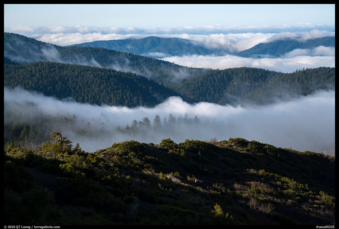
In the morning, trusting Open Street Map that marks Summit Springs Trailhead at the end of 17N29, I followed that road, only to find it washed out a mile from the intersection. A large black bear ran across, and rejoicing in this indicator of wildness, I was somehow glad I had followed this wrong road. Back at the intersection, now convinced that my map that showed 17N06 stopping short of the Summit Springs Trailhead was not up to date, I followed the sign and arrived at a nice loop with a bathroom where I found no other car. The opening in the photo below is the road as seen from the trailhead.

Although I was able to navigate the maze of forest roads with the TomTom automotive GPS app, the surest way to do so would have been to buy a Mendocino National Forest National Forest map – the Snow Mountain Hiking Association website has some great maps, but they cover only the approach from the east side (the San Joaquin Valley), which has the benefit of not requiring the river ford. Google Maps knows about the ford but marks it as a road interruption, so when I tried to map a route to the Summit Springs Trailhead, it returned a very circuitous road, and I did not try to download for offline use. Where Google Maps got it right unlike Open Street Map and AllTrails (who also gets the trail length/elevation wrong since the trailhead is wrong) are the coordinates and access road for the Summit Springs Trailhead.
Along the trail
Snow Mountain can be reached from several trailheads, with the shortest trail starting at Summit Springs Trailhead. Visiting both summits of Snow Mountain, I measured about 10 miles with 2250 feet elevation gain. In the morning, a sea of clouds covered the valleys, and in the afternoon, sunrays pierced the sky as I emerged back from clouds that had begun to engulf the top.
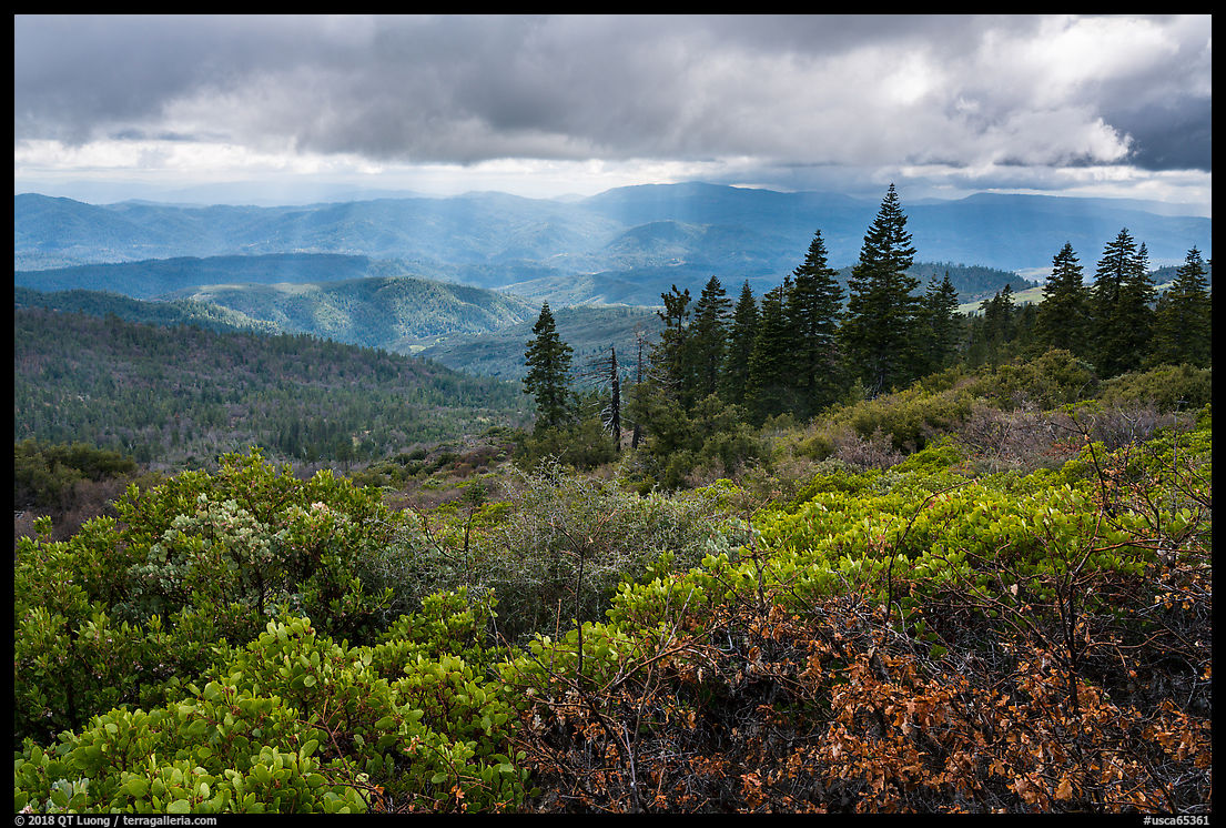
Being an “island in the sky”, Snow Mountain is home to a diverse array of flora. Many of those plants are at their southernmost geographical limit. The trail had started with manzanita-covered slopes alternating with pine trees. It then entered a dark fir forest, before emerging at treeline to cross meadows that still displayed remnants of color from the last autumn. I read that if you come there in summer, you’ll see a profusion of corn lilly reminiscent of the High Sierra. Below the summit, standing tree skeletons bore witness to a large forest fire from 1987. To accentuate their eerie character, I waited for a cloud to photograph the grove without shadows against a blue sky.


Snow
When I mention Snow Mountain, the question I always get asked – after “Where is it?” – is “Is there snow?”. Prior to visiting, I assumed that with the summit culminating at more than 7,000 ft. you’d find some in winter, but I was surprised to see that much remaining at the end of April. In places, the trail disappeared below patches, and I ended up walking cross-country before finding the trail again. Although not ideal in the snow, especially in the afternoon when the snow had softened, my running shoes were adequate, especially since I had packed my hiking poles with me. They were of great help to keep my balance. The snow was not just on the ground. Rising thousands of feet from the surrounding plains, Snow Mountain is tall enough to create its own weather. Despite the weather forecast calling for a partly cloudy day without precipitation, snow flurries began to fall as I was leaving the summit.


Summit
Berryessa Snow Mountain National Monument is located along the Coast Range Fault, the ancient boundary between the North American plate and the lower Pacific plate, once covered by ocean waters. This ancient tectonic plate interaction has created an diverse geology with numerous bedrock types, including the rare serpentine. The trail comes up to a saddle between the twin east summit (7,056 ft) and west summit (7,038 ft). Unlike the lands below, the rounded summits were barren, revealing multi-hued metamorphic rocks that were part of an ancient undersea volcano. Despite this, and the views in all directions, I didn’t linger long because of cold winds and approaching clouds.


Two days before, at the southern tip of the monument, even starting my hike in the late afternoon, I still used my umbrella for shade. Today I had to keep moving to stay warm. Such are the contrasts found in this undiscovered landscape. During my day on this mountain of some significance, I saw only two other parties. Despite Snow Mountain being the peak closest to the San Francisco Bay where one can have such an adventure, it is overlooked by most, compared to more faraway destinations such as the Sierra Nevada or even Shasta and Lassen, which lie to the north. I hope these posts have inspired you to discover a nearby place where it is still easy to experience solitude.
More pictures from Berryessa Snow Mountain National Monument.

