Berryessa Snow Mountain: Northern California’s Mysterious New National Monument
3 Comments
Berryessa Snow Mountain National Monument was established in 2015 to protect more than a hundred miles at the heart of North California’s Inner Coast Range. Although its southern tip is located only one hour from the San Francisco Bay Area, for most people, Berryessa Snow Mountain National Monument is more mysterious than the Sierra Nevada. The first challenge is to locate the monument and its exact boundaries within the mix of USFS, BLM, state, and private lands. Precise maps were hard to come by (the best one is reproduced below) and it took me a while to figure out the roads. During my travels, I did not see a single sign bearing the name of the monument.
California is one of the world most biodiverse places, but the majority of this biological diversity does not reside on the coastline or the Sierra Nevada. Defined in the north by Snow Mountain’s wild conifer forests and in the south by Berryessa Mountain’s oak woodlands and chaparral, Berryessa Snow Mountain National Monument is home to 1700 plant species of which several dozen are found nowhere else, and 80 distinct vegetation types. It also forms an important wildlife corridor.

(click on map for larger view)
Berryessa Snow Mountain National Monument, long and thin, is bisected by Highway 20 which links Williams to Clear Lake. This post will concentrate on the lands south of Highway 20, anchored by Berryessa Mountain and Lake Berryessa. Snow Mountain is the subject of the next post.
Annie’s Rock, Stebbins Cold Canyon Reserve
Less than an hour and half away from San Francisco, Stebbins Cold Canyon is a detached unit (Lake Berryessa was not included in the monument to avoid pushback from boaters) that makes for a good introduction to the Berryessa Snow Mountain National Monument. Stebbins Cold Canyon is maintained as an ecological preserve by the University of California, and its trail system is open to the public. The steepness of the canyon leads to a range of habitats and beautiful views, but also challenging hiking – 2,300 feet elevation gain for Annie’s Rock.
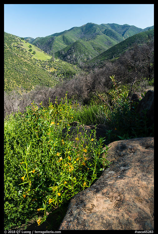
The trailhead is on the north side of Highway 128, less than a mile downstream (East) from the Monticello Dam that forms the south end Lake of Berryessa. After walking through a culvert under Highway 128 to get into the reserve, I joined the loop with the choice of the Homestead Trail (east,left) and the Blue Ridge Trail (west,right). As its name promises, Blue Ridge Trail offers over great views both over Cold Canyon and Berryessa Lake on both sides, but as a ridge trail it goes up and down and is quite rocky in places.

After 2.75 miles, I arrived at a junction. I took the right fork for Annie’s Rock Trail, which adds about 3 miles and 1,000 feet elevation gain. Because of the tree cover, there are fewer views than on the Blue Ridge Trail, except for a short spur that leads to Annie’s Rock. The light was beautiful at sunset, but earlier in the day would have revealed the textures in the rock slab better, since it is slightly tilted towards the east and was mostly in the shade.

Back at the junction, I followed the Homestead Trail (about 2 miles) which descends steeply through stairs and then follows the bottom of Cold Canyon. It was now half an hour past sunset time. Although the scene might have looked quite dark to an untrained eye, a long exposure (8 sec. at f/8, ISO 800, 21mm) showed nuances of light, such as the darker tones of the left slope, which was east facing.

It was pitch dark when I got there, but I still checked out the old homestead site for which the trail is named. Although it is less than impressive, pay attention to the light, which I suspect is better than anything you’d observe naturally during the day there. What looks at first like sunlight streaming in the forest in the photo above was the illumination provided by a mini-lantern hung on a nearby tree, while the forest is backlit by the moon. Near the old homestead site, there was a sign warming that “Hikers are rescued every year, particularly for heat stroke. If any member of your party are at all tired, out of breath, dehydrated or overheated you should turn back and return to the parking lot now”, but although it had been a warm day, I enjoyed the freshness of the night.
Knoxville Road
Besides a short stretch of Highway 20, Knoxville Road (also called Berryessa-Knoxville Road) is the only paved road within Berryessa Snow Mountain National Monument. It runs from the north end of Lake Berryessa and after exiting the monument becomes Morgan Valley Road before reaching Clear Lake. Knoxville Road is a twisting and bumpy road that follows and crosses Eticuera Creek several times.

The quintessential pastoral backroad, it traverses peaceful rolling hills full of oak trees, and gives access to several deserted hiking trails located in the Knoxville Wildlife Area. Although the road is quite narrow, I didn’t have to hesitate to pull out on the side for photos, since during my morning drive, I saw only a few other cars. Both photos on the section were photographed at the edge of the road.

Redbud Trail
The easiest and most popular foray into the Cache Creek Wilderness is through the Redbud Trail, which is accessed via a well-marked trailhead on the south side of Highway 20. The out-and-back trail climbs up a ridge, offering views, then descends to the Cache Creek crossing where most turn around (5 mi RT, 1000 elevation gain/loss), although one can continue to Wilson Valley (14 mi RT). To have a chance to photograph is varying light, I started the hike in the late afternoon, and looked for graphic compositions.

I found plenty of wildflowers along the trail in late April, with the first ones appearing as soon as the meadow next to the trailhead. On the way back, the soft light that occurred when the sun went down was more favorable to depict them.

On my way up, I had spotted a dense patch of lupine along the trail, but the contrasty light did not work well. By the time I got back to it, the light was nice and even, but with the correct exposure for the flowers, the sky was a bit too bright. I again used my mini-lantern to light up the foreground. Since a slight breeze often shook the flowers after I had started a long exposure (20 sec at f/16, ISO 800, 17mm), I had to make several tries.

More pictures from Berryessa Snow Mountain National Monument.


Welcome to NorCal. Your work in the Berryessa region is within 20 miles my home on Howell Mountain. Thank you for sharing your pics and words re this wonderful region.
Thanks Craig. You are lucky to live in that region. It feels so much more quiet and lush than the South SF Bay area.
Hello,
Thanks for the wonderful blog post. I worked on the establishment of the BSMNM with so many awesome folks and organizations. We focused on the science of plate tectonics, biological diversity and wildlife connectivity. But, it is also an awesome place to hike, camp, managed off-roading, mountain bikes, horse riding, hunting, angling, botany and more. It is also an important part of Native American history and more recently mining and farming.
We are now working on the BSMNM Expansion Act (Garamendi H.R. 6366) which adds the western portion of Walker Ridge to the monument. It also changes the name of the ridge to Molok Luyuk or Condor Ridge and provides for co-management with tribes.
Cheers, Bob
PS: Annie’s Rock is named after my dear friend and first wife Anne Schneider who helped make the BSMNM a reality.