Five Spots for Photographing Lassen Peak
No Comments
Established in 1916 on this day, Lassen Volcanic National Park is one of the country’s oldest national parks. However, it is one of the least visited, maybe because it is relatively far from major metropolitan areas and other California attractions. This article presents five diverse locations, ranging from roadside to strenuous hikes, from which you can photograph the namesake volcano, Lassen Peak.
The only reason it was not in the Top Ten Less-Crowded National Parks article is that I had included Lassen Volcanic National Park in another recent Outdoor Photographer feature. Even in the middle of summer, when the other California mountain parks are packed, I can easily get away from the crowds in this hidden gem. The mountain terrain—adorned by conifer forests, meadows, streams, lakes, and clean, dry air—reminds me of the Sierra Nevada Mountains, but add in a variety of unusual volcanic landscapes, and the park becomes a surprising kaleidoscopic wilderness.
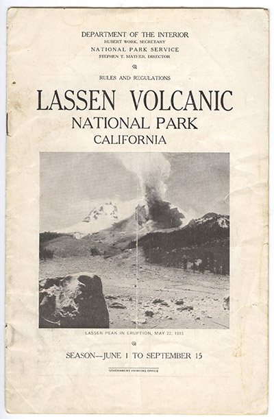
About half of our current national parks were first protected as national monuments, but Lassen Volcanic has the distinction of resulting from the merger of two national monuments established in 1907 – just a year removed from the Antiquities Act of 1906: Lassen Peak National Monument and Cinder Cone National Monument. At the time of the 1907 proclamation, Lassen Peak was considered an extinct volcano, although the native population thought otherwise. They were right. Lassen Peak had a series of eruptions from 1914 to 1921, which provided the impetus for the establishment of Lassen Volcanic National Park as the home of the only active volcano in the United States proper.
There are a total of five entrances to the park. The main road, CA-89, which is the focus of most visits, is a scenic drive with dramatic elevation gain. It skirts three sides of Lassen Peak, offering varied views and trailheads, which this article describes from north to south. From the south end of the scenic drive near the main visitor center, Lassen Peak is mostly hidden (opening image), whereas it is prominent from the north end of the scenic drive near Manzanita Lake and the main campground.
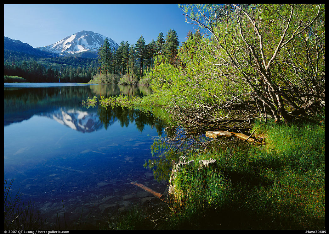
Manzanita Lake
Lassen Peak is the snowiest spot in California and it is not unusual for 40 feet of snow to accumulate on the main road at its highest point. Snow closes all the park roads in winter and the park doesn’t fully reopen until as early as mid-May or as late as mid-July. However, thanks to its lower elevation, Manzanita Lake is accessible year-round. My favorite season there is the spring, when the volcano is still snowcapped and the tender green of newly leafed trees colors the shores of the lake. Light is favorable from late morning until sunset, as the volcano is backlit at sunrise. A flat and easy 1.5-mile trail circles Manzanita Lake. The shore of the lake is the only easily accessible place in the park where you can see the full elevation of Lassen Peak. After parking at the Loomis Museum, it is only a short stroll on the west shore to the best views of Lassen Peak. The classic composition centers Lassen Peak with its classic reflection. Instead, for contrast I juxtaposed a foreground of vibrant greens leading the eye to the peak.
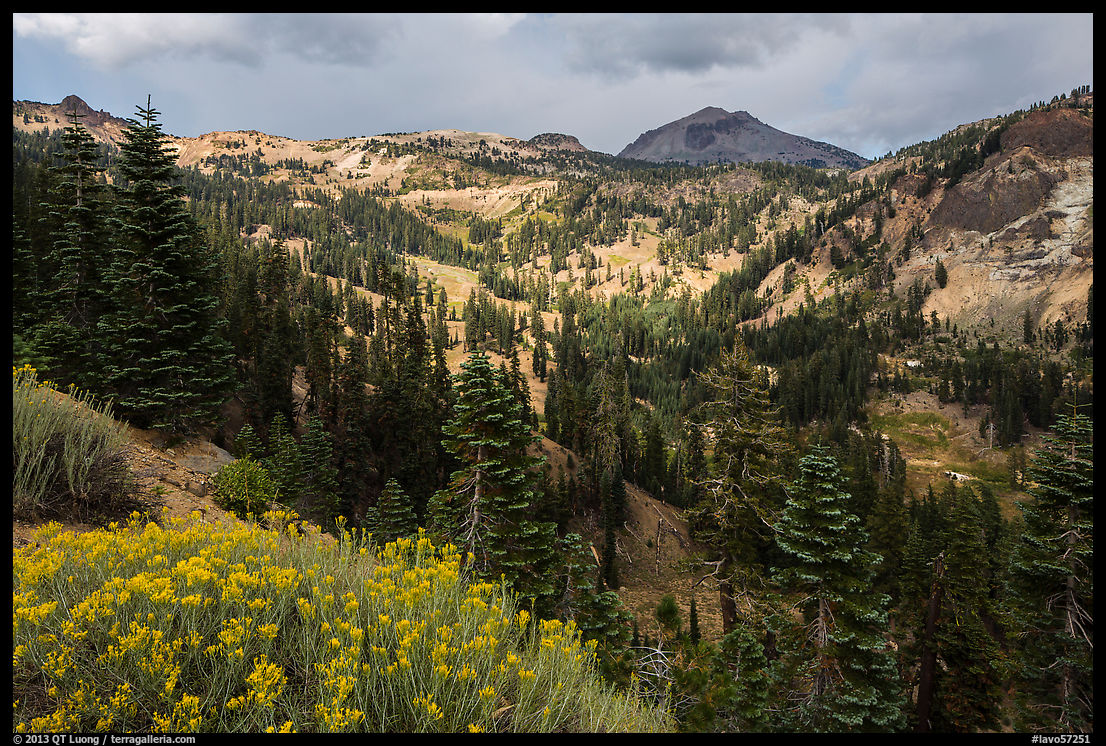
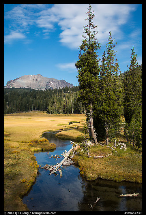
Upper Kings Creek Meadow
Between the Kings Creek Falls trailhead pullout and the side road to the Kings Creek picnic area, there is a delightful sub-alpine meadow right on the north side of the road that invites wandering. Up until early summer, the grass is green and wildflowers abound, whereas later in the season, the meadow takes on a golden hue. If you photograph toward Lassen Peak, the light is best from sunrise to midmorning. A meandering clear stream provides leading lines and possible reflections of Lassen Peak. The peak isn’t as majestic as from Manzanita Lake, so I looked for more compositional elements to include in the image.
Lassen Peak
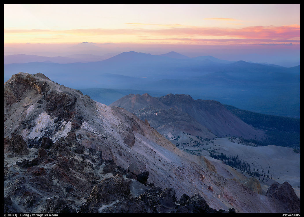
Considered by many to be the park’s ultimate hike, the popular trail to the top of Lassen Peak, almost entirely above the tree line, amazes with panoramic, far-reaching views of the surrounding area. As it is the highest point in the park, watch for dangerous summer afternoon thunderstorms! Starting near the road’s highest point at 8,500 feet, the trail is steep and relentless, gaining 2,000 feet in elevation in over 2.2 miles (one-way) of switchbacks. After catching my breath and putting on a warm jacket, I set out to explore the summit area on user trails, as not a single point offers the best views in all directions. Many views from mountain tops lack a close point of interest, but the top of Lassen Peak forms the gaping maw of the largest plug-dome volcano in the world, full of rocks of remarkable shapes and colors. For photography, without the low light of early morning or late afternoon, I find that those expansive views can look flat. The best time is late afternoon through sunset, when the low sun highlights the jagged summit volcanic rocks and receding distant ridges. After the sun had set, the more uniform light unveiled the subtle colors of the rocks.
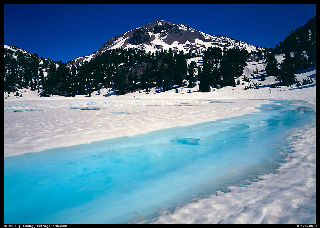
Lake Helen
Named after painter Helen Tanner Brodt, who in her pursuit of a view of the surrounding landscape became the first woman to reach the summit of Lassen Peak in 1864, the tarn lake is a roadside stop. Because Lake Helen lies at a higher elevation and is closer, Lassen Peak also appears shorter from here than from Manzanita Lake. Since you are photographing Lassen Peak from the south, the mountain is well-lit all day, although not at sunrise or sunset because Lake Helen, nested in a bowl, is in deep shade. At those times of the day, the angle of light is more favorable in the winter, just before the first snow closes the road. Shortly after the opening of the main road, in late spring, the ice breakup creates a wonderful turquoise color in the lake. Even though midday is sometimes shunned by landscape photographers, at that time more light penetrates the water, revealing more of the color.
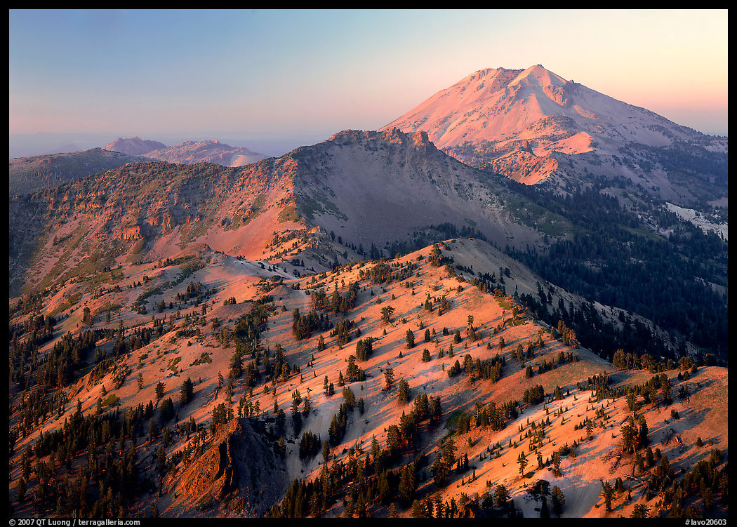
Brokeoff Mountain
The collapse of a former giant stratovolcano, 9,236-foot Mount Tehama, left a caldera surrounded by a crown of peaks that extend from Brokeoff Mountain to Lassen Peak. The trail to Brokeoff Mountain is even more strenuous than the Lassen Peak trail, gaining 2,600 feet in over 3.5 miles (one-way). It is much less known and popular, with only room for 16 vehicles at the trailhead, therefore much quieter. I find it to be an even more rewarding mountain climb. It presents more variety, passing open meadows and forests with wildflowers from July to August, depending on the elevation. It also offers the best summit view in the park. Since Brokeoff Mountain is not the highest peak, the view from its summit is more interesting because you can include the whole chain of mountains leading up to Lassen Peak. Sitting on the ridge, I could trace the edge of the gigantic collapsed Tehama supervolcano. I waited for the time just before sunset, when the low sun colored the whole landscape with pink hues. As usual, I descended the trail in the dark.