Berryessa Snow Mountain Superbloom?
2 Comments
The April trip to Japan and its aftermath made me miss the California wildflower season, which due to the winter’s abundant rains, was a super bloom. In early May, figuring out that Southern California would be long past peak, I went on pursuit of wildflowers in Northern California. The northern part of the state doesn’t have famed wildflowers areas such as Antelope Valley or Carrizo Plain, but I thought that my best chance beyond the Bay Area would be in Berryessa Snow Mountain National Monument and adjacent areas. The official Bureau of Land Management (BLM) signage for the monument should not prominently include California poppies for nothing, right?

Zim Zim Fall
Tuyelome (pronounced too-lee-OME-ee) is a grassroots conservation organization working in the Northern Inner Coast Range of California that was instrumental in the establishment of Berryessa Snow Mountain National Monument. Its name is a Lake Miwok Indian word that means “deep home place”. Nate Lillge from Tuyelome, who had authored the introduction for Berryessa-Snow Mountain National Monument in Our National Monuments suggested wildflower areas. The pictures from a hike he had led to Zim Zim Fall looked promising, as California poppies carpeted the slopes even on that dry year. I picked up that hike for my first destination.From the west shore of Lake Berryessa, I turned onto the Berryessa-Knoxville Road, which is always a delight to drive if you take your time. The quintessential backroad, it is narrow and windy, but also remarkably quiet and beautiful. The pavement was even rougher than I remembered it, with so many deep potholes that it required the same precautions as an unpaved road. By the time I got to the trailhead, a small pullout on the east side of the road 24 miles later, I had not seen a single other vehicle. Berryessa Snow Mountain National Monument is a patchwork of state and federal lands under the supervision of a medley of agencies. The Zim Zim Fall hike takes place on lands that are managed by the California Department of Fish and Wildlife.

The trail starts on the west side of the road beyond a green gate. I quickly reached a creek crossing. Since I read that there were a lot of them (I would count ten), I did not attempt to keep my shoes dry by stepping precariously on rocks, but instead walked straight into the streambed. When I got to the second crossing, I was glad for my prior decision, since this time, there was no way not to get wet feet. After the wet winter, the stream level was probably higher than average. Fortunately, unlike when I hiked the Paria Canyon, the temperature was moderate enough that my wet feet were not uncomfortable, and I felt no need to change socks. The stream crossings added a little adventurous note to the easy hike.
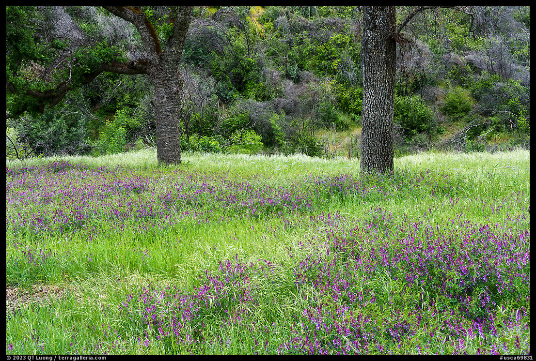

The trail is an old ranching road that follows the Zim Zim Creek along a gentle valley, crossing meadows below rolling hills. While at no point the wildflowers were dense enough to form a carpet, I found a few nice-looking patches, which is enough for a photograph. The grass was a lush green. Was it outgrowing the flowers? Or was I past peak?


About three miles from the trailhead, the trail makes a sharp right turn and starts gaining elevation more steeply – if you continue straight, tough bushwhacking takes you to the base of Zim Zim Fall. As the official trail traverses the side of the valley opposite the waterfall, excellent distant views are available. The waterfall faces East and is sunlit in the morning.


Half a mile after the turn, a single-track trail leads steeply down to the base of the waterfall. As the main trail continues to gain elevation, views over the Zim Zim Creek Valley open up. I hiked to a saddle about four miles from the trailhead (elevation gain 800 feet). From there, it is possible to come back along a ridge for a loop, but since I had not checked out the waterfall’s base, I backtracked instead. By that time, the weather had turned cloudy, and it was dark enough that stopping down to f/11 and using ISO 50 was enough to slow the shutter speed down to 1/20 seconds to smooth the water. At least, I didn’t carry the tripod for nothing. Zim Zim Fall is one of the most accessible, year-round waterfalls in Berryessa Snow Mountain National Monument. Although I did not find a super bloom, the hike turned out to be very rewarding. Maybe it was because it was a weekday, but by the time I returned to the trailhead, I hadn’t seen a single person. It was only after the Berryessa-Knoxville Road turned into the better-maintained Morgan Valley Road at a pass marking the monument’s boundary that I encountered other cars on the road.
Indian Valley and Walker Ridge
North of CA-20, the character of the monument changes, as shrubs and conifer forests replace grassy oak lands. The unpaved Walker Ridge Road is the best road in the monument for panoramic vistas, offering terrific views across barrens, including Mt. Diablo, the Sierra Nevada, Mt. Shasta, and Mt. St. Helena. At a closer distance, the monument’s namesake Snow Mountain, as well as Indian Valley Reservoir are prominent. Walker Ridge Road starts on the north side of CA-20, about 12.5 miles from the junction with CA-53 to the west or 6.2 miles from the junction with CA-16 to the east. The last time I drove with a Subaru, I found Walker Ridge Road well-graded and quite easy. It could be because this time I came with a Prius, which has some of the lowest clearance of any sedan, or it could be that the road had degraded due to the abundant winter rains of the 2022-23 winter, but this time, although I had no issues, I needed to drive with great care. The few other people I encountered all drove high-clearance 4WD vehicles.

About 5.2 miles from CA-20, a secondary road leads west towards Indian Valley Reservoir, a large artificial lake offering recreational activities such as boating and fishing. Its 300,000 acres fall within the larger Indian Valley/Walker Ridge Recreation Area. I found the road closed before reaching the Indian Valley Reservoir Campground. About a mile and a half up the road, the Blue Oaks Camp offered 6 campsites with picnic tables, fire pits and vault toilets, but no water. Pulling into the campground and intending to go to sleep early, I was wary of the other campers’ music, and instead drove down the road again.

Unlike in national parks, dispersed camping outside of official campgrounds is generally permitted in national monuments. I found a nice pullout overlooking the lake where previous occupants had built a fire ring. While the water was boiling for my dinner, I made a few night exposures. The sky, which had been cloudy for most of the day, had cleared and the moonlit scene was rendered by the camera similarly to a daylight scene with a few stars. To render them as points with a 24mm f/2.8 lens, I kept the exposure to 10s, resulting in a ISO of 800. I tried out the new AI-based noise reduction available in Lightroom 12.3, and it did an excellent job, easily as good as the specialized Topaz DeNoise. Since it is included in Lightroom, give it a try if you haven’t yet! Hopeful for good light at sunrise, I went to bed cowboy-style, sleeping on the ground rather than inside my cramped car. The forecast had called for mostly cloudy weather, but no rain. Half an hour before sunrise, I was awakened by raindrops. I retreated into the car and went back to sleep, regretting not having taken advantage of the moonlight and window of clear early night sky to make more compositions.

After the rain stopped, I walked down the closed road to the campground, which is quite large and ideally located at the lakeshore. Right at the water’s edge, I found a few clusters of California poppies. Although far from spectacular, they were still the best I had found in the monument. However, it was still early in the morning and quite chilly, so the flowers had not opened.

I drove back to Walker Ridge Road, and not far from the junction with the Indian Valley Reservoir Road, I started a hike on the east side of the road to explore the serpentine barrens on foot. Serpentine is a rare bluish-green rock derived from the earth’s mantle. Soils formed from serpentine rocks lack certain elements required by most plants, prompting adaptations resulting in species not found anywhere else.

The area has two prominent rock formations called Signal Rock and Eagle Rock that can be both visited via a loop of about 8 miles. It was a bit confusing because of a large number of intersecting trails of various widths, some narrow single-tracks, and others jeep roads. I was glad that I had a GPS app. The terrain was definitively not a good place to look for wildflowers. Upon arriving at Signal Rock, I was unimpressed by the formation, but before leaving, I decided to do a scrambling circumnavigation to see what I could find.

From its other side, the rock loomed more impressively, and I saw a few clusters of sunflowers. It is very rare that I set my 12-24 zoom at its widest setting, but that was one of the occasions that called for such a radical perspective, as it would make the sunflowers prominent enough in the photograph to give it life by contrasting them against the dark rock and creating a Z-shaped visual path leading up to the otherwise modest pinnacle.

I didn’t find anything close to super bloom I was looking for, but I had met the secondary goal of my trip, which was to find out what the proposed Molok Luyuk (“Condor Ridge” in the Patwin language, as provided by the Yocha Dehe Wintun Nation) addition to Berryessa Snow Mountain National Monument was about. Walker Ridge Road, Signal Rock, and Eagle Rock are currently adjacent to the monument, but not included within. The
click on map for larger version


Very nice images. Must have been great to be there at such a quiet time. Admire your ambition of going off-grid in a Prius!
My son attends Cal Poly San Luis Obispo, and did make a visit to the Carizzo Plain superbloom. He told me it was beautiful, but very crowded. I’d like to visit some year.
Martin Cutrone
Thanks Martin. I’ve always found Berryessa Snow Mountain National Monument very quiet. The Carrizo Plain gets busy only during superblooms, but is quiet otherwise, although there is still plenty to see as I wrote in Carrizo Plain beyond the superbloom.