Yosemite Unseen VI: Mount Conness Loop
5 Comments
In this post, I am sharing my favorite high-country hike in Yosemite. On that rugged, but short Yosemite backcountry loop, you’ll reach the Sierra Crest, high above timberline, only a few hours after leaving your car, and enjoy a few days of solitude from there. You will roam cross-country – which is surprisingly easy here because you are above timberline, camp next to rarely visited lakes, and experience some of the most spectacular and varied mountain terrain in the park, concluding with the ascent of an extremely scenic peak.
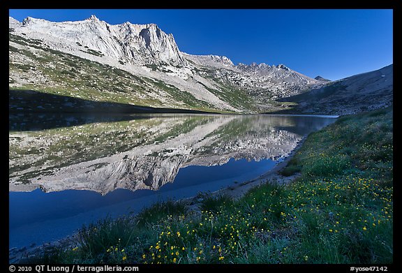
To undertake this loop obviously requires some backpacking experience, as well as the skill to navigate cross-country in some class 2 terrain. The best time of the year is normally mid-to late summer, as snow can be a problem early in the season (not this year, though !). Despite backcountry quotas, I easily obtained a permit at the Tuolumne Meadows Wilderness Center on the morning of my start, in August. The loop can be done in three days. I hiked at a leisurely pace in four days (three nights). As an instance of taking my time, I arrived at the spot in the first image on the first afternoon. After sleeping at Upper McCabe Lake I climbed back the next day there, as the light is better in the morning, then explored the ridge up until the point where it turned to class 4, before backtracking and resuming the journey.

(click on map for larger version)
Take California Highway 120 (Tioga Pass Road) to about 2 miles east of the east entrance of Yosemite National Park, turn to Saddlebag Lake Road on north side, drive to the end and park at the Saddlebag Lake resort (10060 feet). From there go to the NW end of the lake, by hiking on either shore, or by a boat taxi, – which saves you 1.5 miles (every 1/2 hour, 7am-5pm).
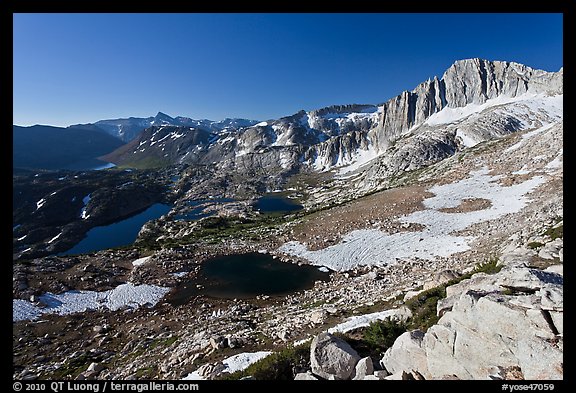
Follow a trail heading towards Steelhead Lake skirting it on its East shore. The trail climbs and peters near the remains of the Hess mine, where a century ago miners toiled not too successfully for silver. For the next few days you’ll wander cross-country, and will share the mountains with only a few other hikers. Zig zag the steep slope, and soon you’ll straddle the Sierra crest, above 11,000 feet, with great views of North Peak and the enchanting Twenty Lakes Basin.
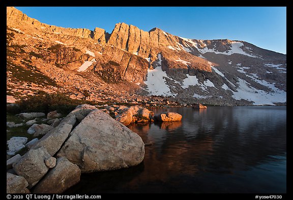
The other side consists of steep cliffs, but north of them, you’ll find a gully system that leads down to Upper McCabe Lake. At sunset, North Peak reflects beautifully in the lake.
Go around the lake clockwise. From its south shore, before reaching a small peninsula, you’ll see a pass between Sheep Peak and North Peak. Scramble up the talus and snowfields, then descend the gently slopping valley on the other side of the pass.
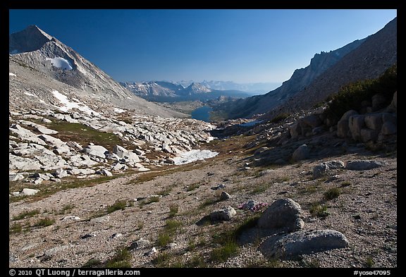
You’ll soon reach narrow Roosevelt Lake. Follow the east shore, then continue south.
After passing verdant meadows and clear streams, for the first time since the start of the trip, you’ll be passing below timberline and hiking in the forest. Track a contour line to reach Lower Young Lake, where you re-encounter people (I had met a single party around Upper McCabe Lake, and also Roosevelt Lake) as well as an established trail.
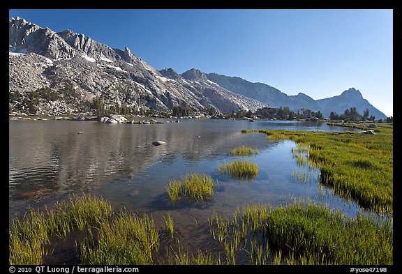
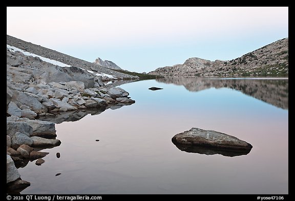
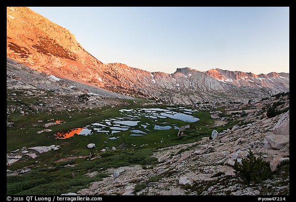
Follow it up to Upper Young Lake, after which it turns into an unmaintained climber’s trail. Continue up as you make your way back to the alpine world, arriving at the south slope of Mount Conness, passing on your way a high-altitude meadow doted with tarns.
Leave your backpack at the crest near the pass, and follow the class 2 trail to the summit (12,590 ft), first ascending a broad slope, then once on the plateau, following a thin ridge with a few exposed passages.
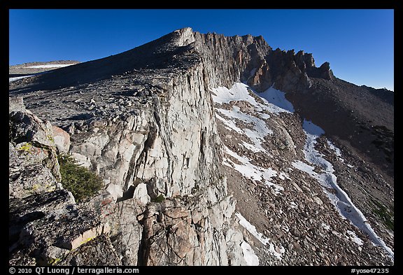
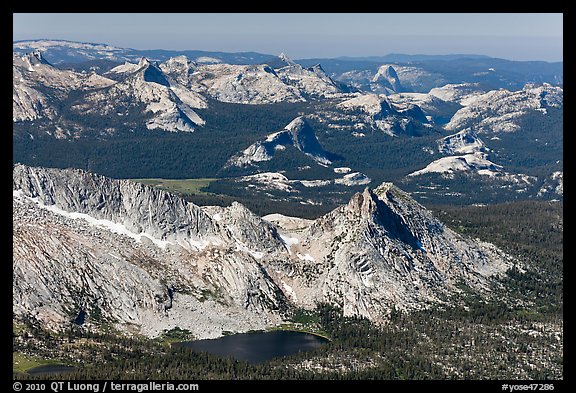
The highest peak in Sierra Nevada north of Tioga Pass Road, Mount Conness offers wonderful views of the high country granite domes, extending to Half-Dome, as well as a glimpse of the Northern Yosemite.
Back at the pass, descend steep slopes on the East side. The inclination is about 30 degrees and the slope is north facing, so in early season snow climbing gear (ice axe and/or crampons) may be useful, especially early in the day. Then follow the main drainage. When you reach the Carnegie Institute Experimental Station, you’ll see an established trail. You can either follow it to the Sawmill campground and then walk a mile up to road, or take a more direct off-trail shortcut to your car.
I planned this itinerary by just looking at a topo map, then confirming its feasibility at the wilderness center when I picked up the permit. Once you begin to venture out of the beaten path, you can create many itineraries as beautiful as this one. The possibilities in Yosemite are endless. Please share your favorite finds !
Part 6 of 6: 1 | 2 | 3 | 4 | 5 | 6
Check out my book: Spectacular Yosemite


I’ve come back to these photos now a few times, and find them very captivating. They’re not flashy or gaudy, just very good, and they trigger a strong emotional response in me. Beautiful.
I see you’ve done considerable work with film — I’m curious whether you worked with film or digital on these.
Thanks for the kind words. Over the years I’ve indeed evolved towards a more subtle approach to the landscape. Those were all photographed in digital (5D mk2) as I wanted to enjoy a light pack.
Wonderful Work QT..I would bring my Leica with BW FIlm too perhaps next Your work time would look great on BW Film here.
Dietmar
Personally for BW photographs in 35mm I prefer to use digital capture in color and convert to BW. You can make BW from color, but not the opposite.
Great work! Photographing landscapes in the mountains near Tioga Pass is difficult because the light colored rock seems to drown out the image. My favorite shots are when you get sunset lighting and some vegetation features in the foreground to give the image some variety. Thanks for toting a camera to these wonderful places.