Steps behind the image: Echo Crater
3 Comments
Craters of the Moon National Monument and Preserve is an immense, well-preserved and diverse volcanic landscape with remarkable features spanning 1177 square miles in South Central Idaho. Most visitors spend all their time in the National Park Service (NPS) Developed Area. Although only a small 16 square miles, that part of the monument lives up to its name, is it does include most of the monument’s facilities, among them a visitor center and a well-equipped campground. Since Craters of the Moon is not among the high-profile NPS units, I was surprised that in September the campground had filled out. Of all the areas in Craters of the Moon National Monument and Preserve, the NPS Developed Area has the densest concentration of natural features. They are reached via a 4-mile loop drive leading to short and well-marked trails.
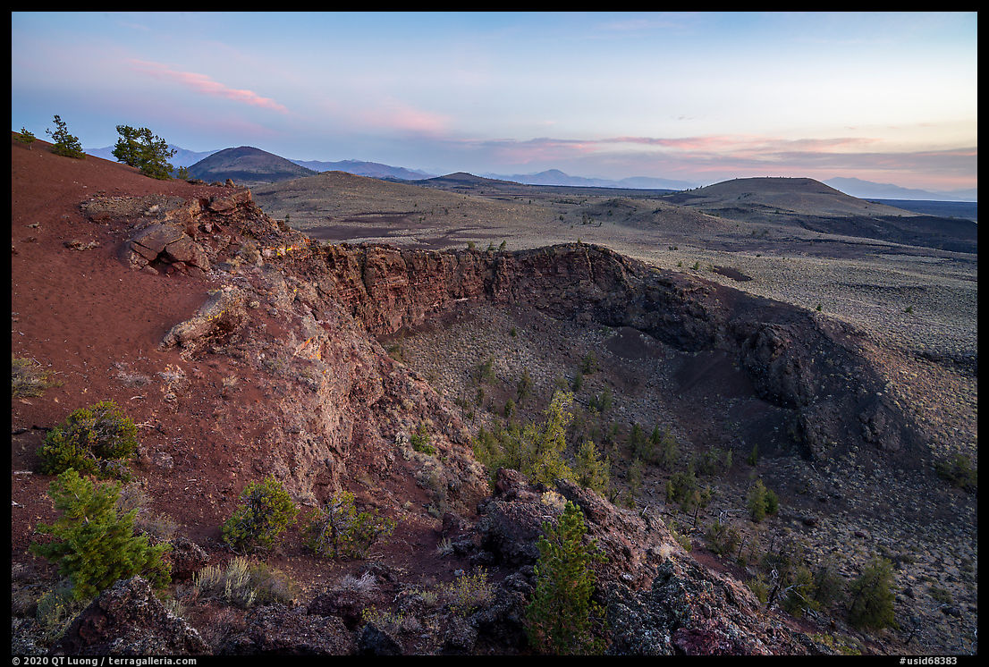
For an iconic photograph, I sought a high point to picture the vast expense of the monument combined with a defining volcanic feature, but the choice in the Developed Area is limited. To protect resources, off-trail hiking is strictly regulated there – footprints in cinder remain for a long time, so summits such as North Crater are closed to hiking. From the one summit that is open to hiking, Inferno Cone, the Loop Road was too prominent. This led me to look into the Wilderness Area where by definition, there would be no roads. The NPS Wilderness Area (68 square miles) borders the NPS Developed Area to the west, east, and mostly south for a stretch of about 10 miles. Both areas are part of Craters of the Moon National Monument as it was established in 1924, before the huge expansion of 2000. After a bit of research, I determined that Echo Crater would be a promising destination. The crater rises high enough above the Snake River Plain to offer an extensive view of the surrounding landscape. Even if the photos posted by previous hikers were not great, they showed distinctive features that in better light could make a compelling middle ground. I determined that sunrise would be the best time, since I would be photographing towards the NW towards the Developed Area with Big Cinder Butte as a focal point, an angle that would provide good illumination with a bit of cross-lighting.
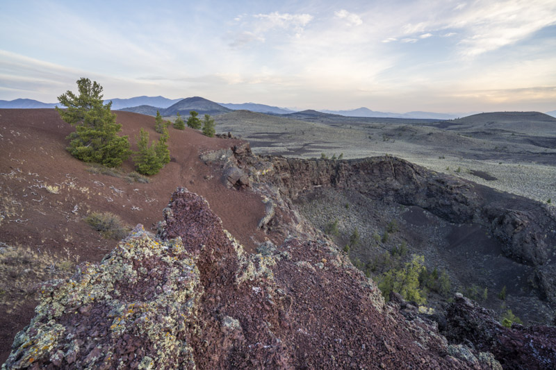
Craters of the Moon Wilderness is one of the most easily accessible designated wilderness areas in the country. It starts just 0.75 miles from the Tree Molds parking lot, and is accessed via the Wilderness Trail, which is almost flat. The 5-mile trail, ending at a crater called The Sentinel, passes next to Echo Crater about 3.5 miles from the trailhead. The NPS indicated that Echo Crater is a popular backpacking destination, but since the day before was so windy, there is no water there as the volcanic soil is porous, and a backpacking permit is required, I thought it would be simpler to approach it as a day hike. On Sept 25, the sunrise was at 7:24am, so I set up my alarm clock for 4am. The wide trail was easy to follow at night, and as it grazed the crater in pre-dawn, I bushwacked along the steep flank straight east to the top. With sheer walls below me, and a drop of several hundred feet on both sides, the view was even better than I anticipated. In the soft and directional light that occurs 15 minutes before sunrise, I made a satisfying photograph without a close foreground (opening image).
For a second composition to be made after sunrise with more vivid colors, I looked for a foreground to illustrate the beautiful texture of the volcanic rocks, and I also wanted to put more emphasis on the remarkable red cinders of the crater. I scrambled along a ridge and found a triangular shape that I used as foreground. However, it cut into the crater, making the picture difficult to read.
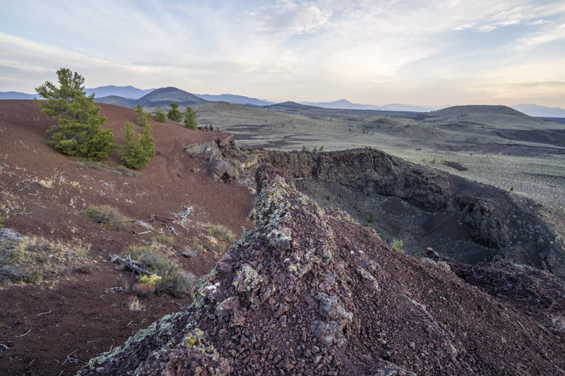
I moved a few steps to the right, which by the way is easier said than done, as the ridge was steep, narrow, and exposed. The foreground rocks now don’t interrupt the shape of the crater, however they don’t detach cleanly against the cinder slope due to the dead tree sticking out.
I lowered the camera by about one foot, thus hiding the dead tree behind the foreground rock. The diagonal of the rock originates from the lower left corner, making a better leading line. The composition is now established, and I just need to wait for sunlight. It was already past sunrise time, but the sun was still behind a bank of clouds on the eastern horizon.
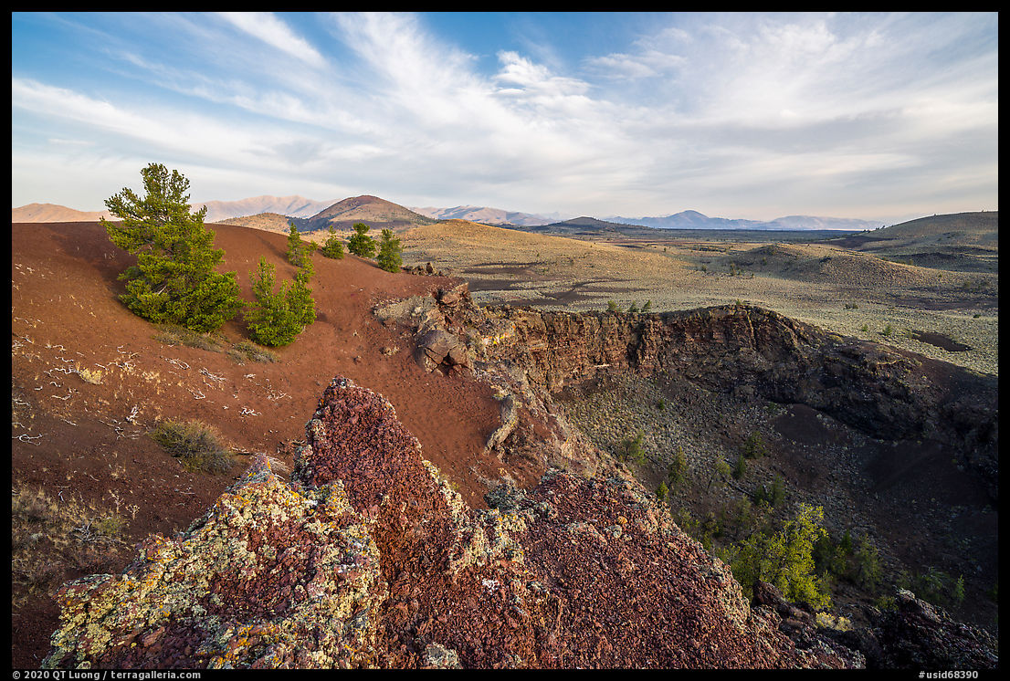
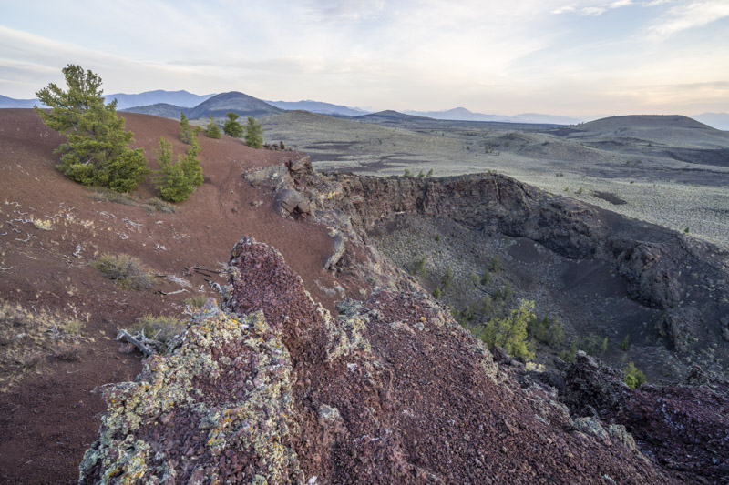
I made the photograph just when the first rays of sunlight reached the crater. The sun was still partly occluded, resulting in light bright enough to enliven the landscape, yet soft enough to reveal all of it.
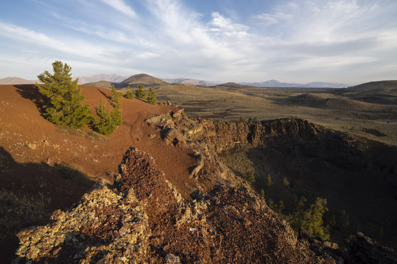
Less than one minute later, hard shadows have already obscured the crater, as well as broken the cinder cone slope. If I had waited for the sunlight to come before establishing the composition, that interval probably might not have had been enough fore me to get it right. Time to move to a different composition!


Thank you, QT, for the detailed explanation of the multiple steps you documented in your post – STEPS BEHIND THE IMAGE: ECHO CRATER. Your time, effort and creativity made a wonderful photo. And I appreciate very much your step-by-step explanation of how you composed each shot in the sequence leading up to your wonderful photo of the first rays of sunlight reaching the crater. Your explanation reminded me of a statement by Louis Pasteur (the 1800s French scientist): Fortune favors the prepared mind.
Thanks Peter. I usually work quite instinctively and don’t take the intermediate photos, but in this case I had a bit of time to kill while waiting for the light.
I’d like to second Peter’s comments. I love your posts that show the steps you went through refining your composition.