Santa Rosa Island, Channel Islands National Park
4 Comments
Of the five islands that make up Channel Islands National Park, Santa Rosa Island offers by far the largest area to explore. Backcountry logistics and the size of the island make it difficult to see it all. However, by staying two nights at the nice campground, I covered a good amount of territory on day hikes within 48 hours. Although the island looks barren from a distance, it harbors a great variety of rare plant species and beautiful sights that I’ll illustrate in this post.
Transportation
The park concessionaire, Island Packers, provides boat transportation to all the islands. A day trip doesn’t leave you much time on land compared to the sailing time, which is about 3 hours to Santa Rosa Island each way.
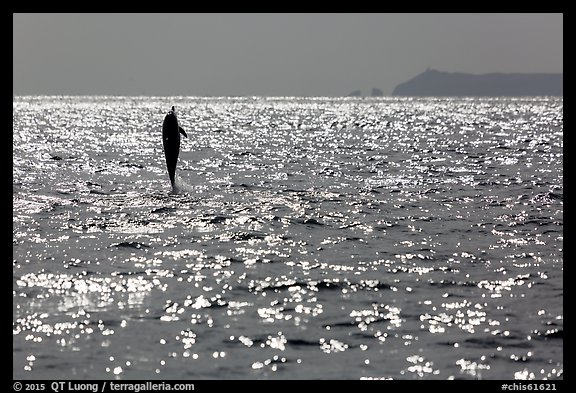
The crossing is scenic, with frequent marine life sightings for which the boat stops.
Camping
Except for beach backcountry camping (mid-August to December), and private research stations, the only place to stay on the island is the campground. It is located 1.5 miles away from the landing pier, in a canyon relatively sheltered from the wind. Motorized transportation is not available to visitors. I brought two backpacks. I packed the first one, with camping gear and food like for a backpacking trip. The second one, to be used as a day bag, was a camera backpack (F-stop Gear Satori). Lugging both to the campground was no worse than the coolers and surfboards carried by other campers.
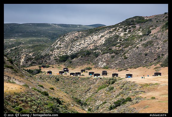
The campground has water (not all campgrounds on the Channel Islands do), and even flush toilets, a nice surprise in such a remote location. In normal years, there are even hot showers, but they were turned off due to the California drought. A wind shelter marks each of the campsites. It proved indispensable since, during the whole stay, winds were howling at solid 30 knots, with occasional stronger gusts. I visited in April even though springtime is the windiest because I was hoping for wildflowers and greenery. However, lack of rain meant that springtime had peaked one month earlier than usual.
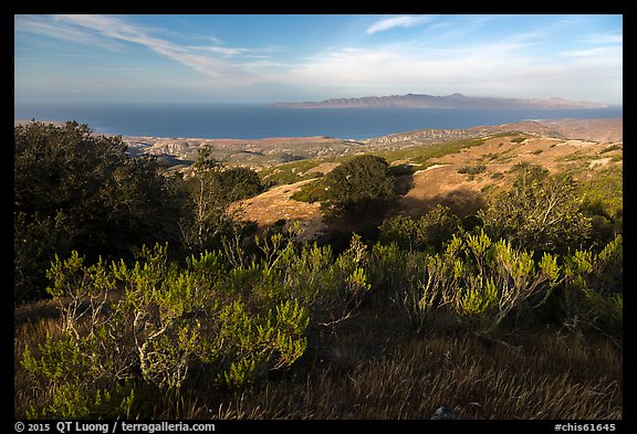
Black Mountain
After carrying my backpack to the campground, to take in a measure of the island’s size, on the first afternoon, I hiked to Black Mountain. The straight round-trip hike from the campground is 8 miles RT. I made a loop through Cherry Canyon, Telephone Road, and Soledad Road. Although combining those trails in this order added quite a few miles, it added variety.
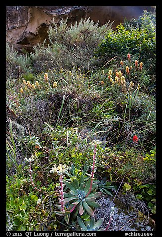
Most of the island is barren. However, the canyons are home to a varied native vegetation. Up until 1998, the island was owned by the Vail and Vickers ranching company, whose cattle grazed most of the island, except for the canyons.
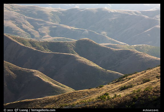
At 1298 ft high, Black Mountain offers expansive views in all directions. To the north, Santa Cruz island appears close. San Miguel Island is visible to the west, and the Soledad Peak range to the south.
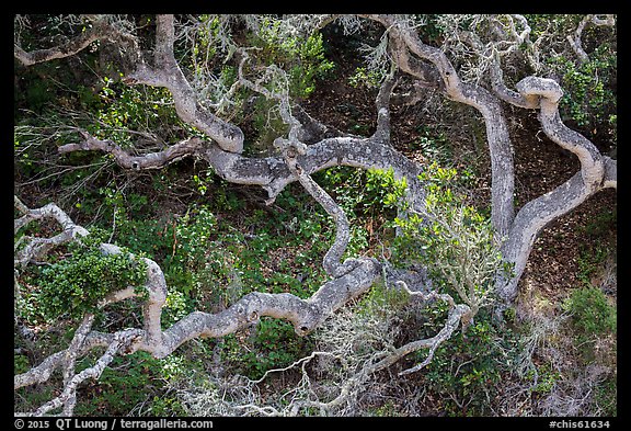
Santa Rosa Island is home to two unique forests. Island Oaks, a subspecies found nowhere else on earth, grow below the summit. They form what is called a “cloud forest” because it is sustained by the moisture collected by the island mountaintops.
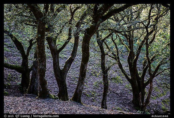
The forest provided a relative welcome break from the wind, but it was time to leave. I had to keep a brisk pace to stay warm. Fortunately, my itinerary let me to go down by dark through the easiest route, the well-maintained Soledad Road, rather than Telephone Road, which has become a steep, sometimes overgrown trail.
Water Canyon Beach
If you don’t feel like taking a long hike, Water Canyon Beach is just 1.5 miles RT from the campground. Even though, it is most of the time deserted and has enough subjects to keep you occupied for a while.
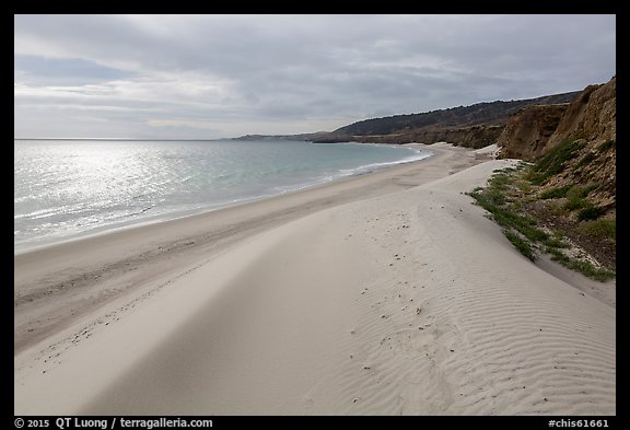
The 2-mile long white sand beach is bordered by cliffs and adorned with dunes and a stream at the mouth of Water Canyon. The first light of sunrise normally illuminates the beach, but the weather was mostly cloudy, so I returned on the next day too.
Lobo Canyon
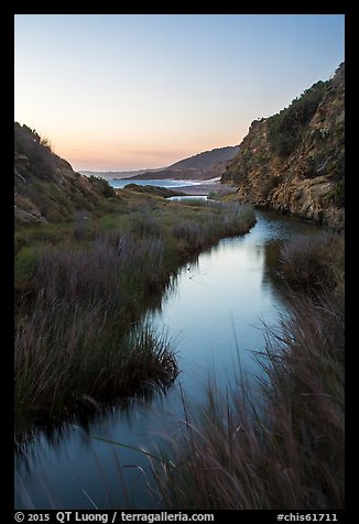
After I had got back to the campground for breakfast, the rain started. Since it was still early in the day, I took a nap. As the weather did not seem to improve, I resolved to start hiking towards Lobo Canyon (13 miles RT from campground) despite raindrops that were flying horizontally at me. Midway, the rain abated, but not the wind. I was happy to find some shelter from it in Lobo Canyon.
Lobo Canyon harbors a riparian environment along a year-round stream that makes it a surprisingly lush place, full of native plants.
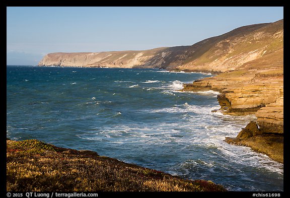
In contrast with Water Canyon Beach, the coastline at the mouth of Lobo Canyon is rocky and precipitous. It was well lighted in the late afternoon.
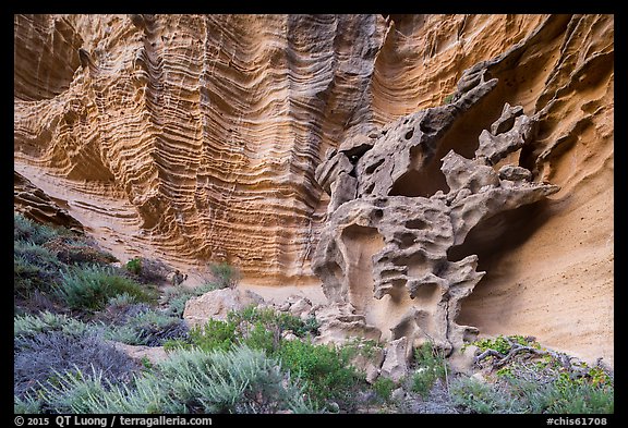
Since I preferred soft light, I photographed the strikingly sculptured sandstone canyon walls on my return hike near sunset. I returned again to the campground at night, but this time with the wind at my back.
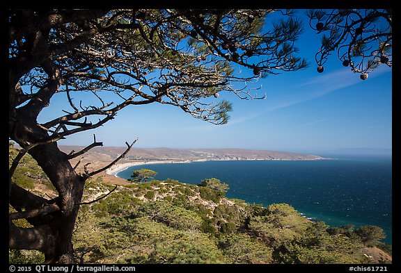
Torrey Pines
The other unique forest on Santa Rosa Island consists of Torrey Pines that natively grow only there, and near San Diego. I photographed them along a loop trail (5 miles RT from campground) which climbs on a hill for good views of the coast. Morning light was excellent for framing Becher Bay with the pines.
I wished I had another full day to explore the eastern tip of the island, however, with the boat pickup rescheduled to 1pm, it was time to pack and ferry the gear back to the pier. National Park visitation is about 330,000, but most make it only to the mainland visitor center. Only 10% set foot on the islands. Do you plan to be one of them ?
View more images of Channel Islands National Park


Great article and photos; very informative! Thank you!!
Love the Channel Islands. Wish I were there, especially after reading your blog with gorgeous photos and words. Your work is wonderful. Thanks!
Great write-up and images as always, QT! I’m embarrassed to say that I’ve never made it Santa Rosa (although I’ve spent much time on Anacapa and Santa Rosa). I’ll definitely need to correct that in the near future!
Thanks Russ. I assume you meant Santa Cruz. Ferry service to Santa Rosa was sketchy in the past, but has improved much in recent years!