Rio Grande Del Norte National Monument in Winter
9 Comments
Many of the large national monuments I have written about during the last two years have one thing in common: they are quite undeveloped. By contrast, although it was proclaimed in 2013, Rio Grande Del Norte National Monument near Taos, New Mexico, already sports facilities close to those found at a national park: visitor centers, several campgrounds, scenic drives, overlooks, and trails. Yet the well-developed national monument is still under the radar of mass tourism. The place was particularly quiet when I visited in late December. Was it a good time to visit? Try to spot anything unusual before reading about the twist revealed at the end of this report.

Lower Rio Grande River Gorge
The main feature of Rio Grande Del Norte National Monument is the deep Rio Grande Gorge cut by the Rio Grande River. The south end of the monument provides the easiest access to the river, as shortly past the village of Pilar, NM 570 follows the Rio Grande inside the gorge, past several campgrounds and picnic areas forming the Orilla Verde Recreation Area, offering close roadside views of the river. The area must be pleasant and popular in summer, when whitewater enthusiasts flock to the river, but I was the only camper at the beginning of winter. The time would not have been my first choice, but I was already in New Mexico for White Sands National Park, and to minimize travel I always try to combine trips. I was expecting to find all the vegetation bare, and from a distance, everything appeared brown. A closer look at the riparian growth revealed a subtle, but varied palette of colors, with red willows the most striking hues. Although it lacked the appeal of lushness, the season revealed more textures.


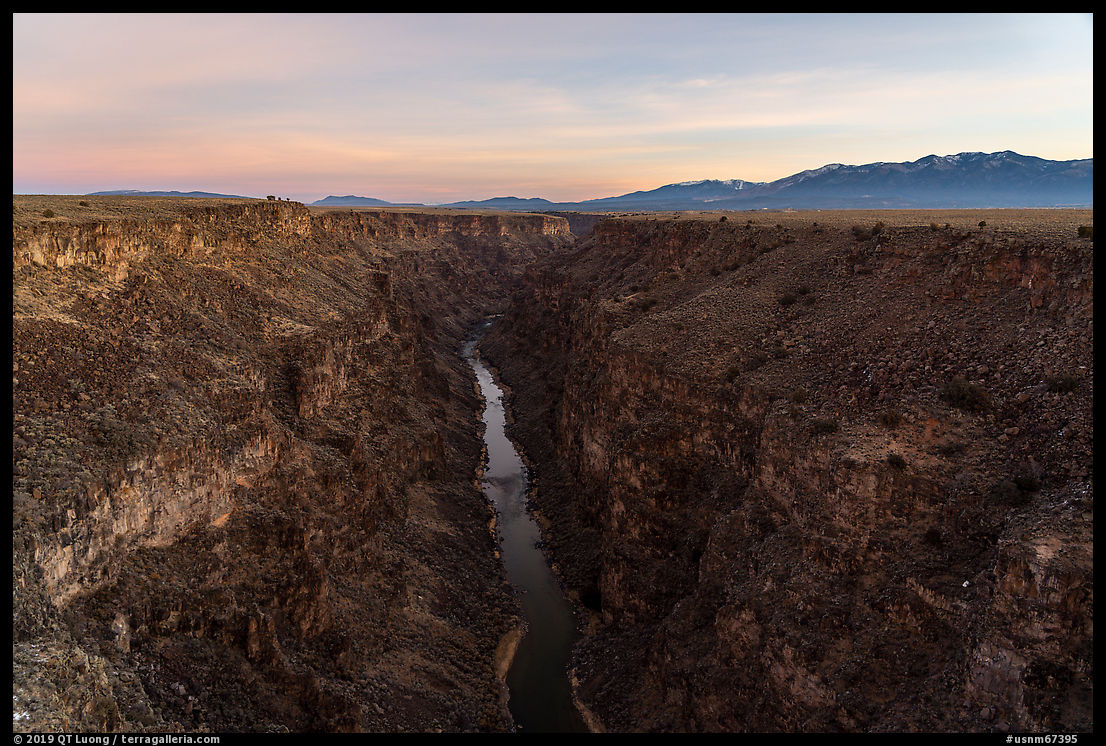
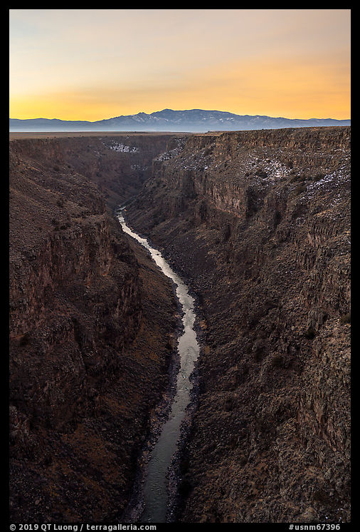
Rio Grande Gorge Bridge
About 10 miles west of Taos, US 64 crosses the Rio Grande Gorge over the Rio Grande Bridge, the most well-known and accessible attraction in Rio Grande Del North National Monument, next to the Rio Grande Gorge Rest Area, a rest stop with a large parking lot. The arch bridge soars 650 feet above the river, with sidewalks on both sides of the bridge. They offer the most impressive views of the gorge, as you can stand directly above the river in a steep and narrow section of the gorge and look at both directions. I usually prefer to photograph deep gorges such as this one in the soft light occurring before sunrise or past sunset to avoid harsh shadows caused by direct sunlight. On that day, I had an additional reason for showing up at dawn. Like for the rest of my visit, the weather forecast had called for a mostly overcast day. A white sky would not complement a dark gorge well, whereas I was hoping for a bit of color in the sky at sunrise. New Mexico’s as a whole is high desert, and most of Rio Grande Del Norte National monument is about 7,000 ft. This resulted in temperatures barely rising above freezing even in the middle of the day. At dawn, with the wind that blew in the middle of the bridge, it was brutally cold, but my main concern was tripod vibration during the longish exposures required by the dim light of dawn.
John Dunn Bridge
The John Dunn Bridge is much smaller than the Rio Grande Gorge Bridge because it is a river level. Besides providing easy river access, the road, unpaved but well-graded, climbs sharply in switchbacks with views of the gorge on the west side. On the east side, it follows closely the Rio Hondo, and intimate nature scenes are just a few steps away. The smaller stream is bordered by vegetation and cascades over boulders, providing more possibilities than the banks of the Rio Grande River. The compositions I found would not have worked as well if the trees had been covered in thick foliage.


Wild Rivers Recreation Area
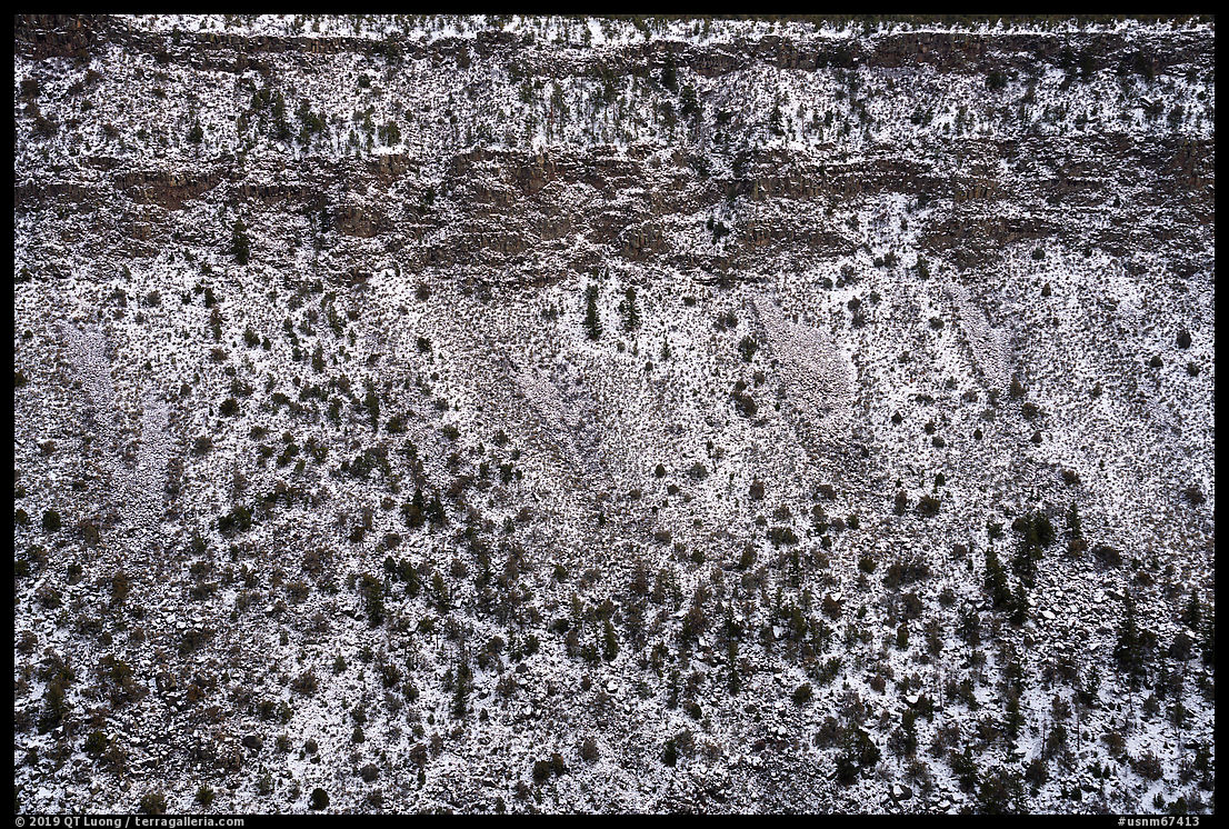
The Wild Rivers Recreation Area, at the end of NM 387, is the most developed area in Rio Grande Del Norte National Monument, with six campgrounds, a visitor center, and many trails. From the name, I expected easy river access. Instead, I found a plateau perched high on the rim of the gorge. Accessing the river from there is through short, but steep trails that descend more than 700 feet. Fortunately, a number of overlooks over excellent views over the gorge. La Junta Point, at the southern tip of the area, provides a view of the confluence of the Rio Grande and Red River. I found the most expansive view to be from the Chawalauna Overlook. At dawn, I set up to photograph the gorge from there, but when I noticed a bright sky in my back, I turned around and looked for a spot with open views of the eastern sky, catching clouds that were colorfully illuminated for just a few minutes. As the Wild Rivers Recreation Area is located at a slightly higher elevation than the Orilla Verde Recreation Area, snow was lingering there, especially on the north-facing slopes. I tried to incorporate those slopes in my compositions, as I liked the texture and the lightness it created in contrast with the volcanic rock of the gorge that otherwise would look dark.


Taos Plateau
Rio Grande Del Norte National Monument’s terrain has been shaped by volcanic activity. Within the Rio Grande Rift, tectonic plates moved apart, creating an opening where volcanoes formed and eventually filed the depression. This resulted in Taos Plateau, an expense of basalt flows capped by dormant volcanoes. Since the portion of the monument covering the Taos Plateau is much larger than the skinny portion along the Rio Grande River, I spent quite a bit of time there driving unmarked dirt roads to see what I could find. This doesn’t always yield interesting scenes, and I found that compared to the rest of the monument, there wasn’t much there, both in terms of sights and facilities. That is a place where a sky energized by clouds such as those found during the southwest summer monsoon would greatly help. Beyond the views over vast sage flats, the best I could do is to locate a small butte, not too far from the road, where the rocks, desert plants, and the slightly higher viewpoint helped with the sense of depth, leading to omnipresent Ute Mountain, a dormant volcano rising over 10,000ft to form the highest point in the monument.


More photos of Rio Grande Del Norte National Monument.
Postscript
The main challenge I faced during my visit was not the season. Why did I mention accessibility so repeatedly? On the first morning, shortly after making the obligatory photographs from the Rio Grande Gorge Bridge, I made a reaching motion the wrong way and twisted my lower back. The pain was intense enough that I considered going home immediately but then considered that I would not be able to take a commercial flight with luggage in my condition. Just getting from standing next to the car (in sub-freezing weather) to sitting on the driver’s seat or vice-versa would sometimes take several careful minutes. If the terrain was not perfectly even, walking more than a few dozen yards proved difficult. It wasn’t just mobility, using photography gear was also problematic. Since I could not bend enough to retrieve gear in my camera backpack, I had to mostly forego lens changes in favor of my trusty 24-105. Using my tripod that extends to 52 inches meant that I had to bend slightly, so I photographed hand-held.All of this made me understand better and sympathize with the plight of those who are limited by their medical conditions, something that is easy to forget when one is climbing mountains. On the flipside, despite of all my temporary limitations, I soldiered on, and was able to make the photographs (only those from the Rio Grande Gorge Bridge precede the injury) that illustrate this article. So it is possible to step out of one’s car and depict seemingly wild scenes – the seasonal lack of traffic certainly helped. To be frank, I initially hesitated to reveal that story because I thought it would not fit with my image of a wilderness photographer, but eventually thought the greater lesson could provide some encouragement. Did you find the images any different from my usual output, and would you have guessed their roadside status?


The red-orange riparian willows look like tamarisk, a.k.a. salt cedar.
Thanks David. I wasn’t sure, so I asked on twitter (https://twitter.com/terragalleria/status/1211773959252758528). All respondents said willows (specifically red willows) and one said tamarisk.
Travelling to New Mexico as a tourist with my sister and her hubby , I happened to be at the back of the car with my nose glued to the pane and the enthusiasm of seeing landscapes so very different from my homeland, I was first struck by the harsh and desolate atmosphere with not a soul or car in sight ,I decided to turn my attention to the beautiful and varied change of landscapes and gradually became mesmerized as the desert beauty revealed itself in extremely surprising and captivating ways…. A super iconic scene of Ansel Adam’s ‘Moonrise’ ,flashed in front of me and as I traversed both literally and figuratively ,I discovered to my utter amazement the sheer contrasts that the grandeur of New Mexico represents…Your photos depict that beauty vividly and exquisitely.Thank you for sharing …Always love reading and viewing your write up and images.
Thank you Rita for the kind words.
To answer your question simply- No! I have driven the same route as you did many times and recognize the location of several of your images ( or at least I think I do) but in no way do they look different from photos you might make many miles from any road or vehicle. Great photographs do not require a unique location or subject. They are created by the photographer.
I hope your back improves soon! I understand your frustration, after years of hiking and enjoying the solitude of the backcountry I’ve spent the past year on crutches, due to a fall in my kitchen 🙁
One year on crutches, that is awful. I wish you prompt recovery. My accident was nothing in comparison. By the way, yesterday I slipped and fall in the kitchen, fortunately without consequences. The outdoors are not necessarily the most dangerous places to be.
Sorry to hear about your back. No, I did not notice that these were roadside pics at all. Composition with a zoom lens helps when mobility is lacking or when you can’t reach the spot. Bravo for marching onward.
Thank you for this report about a really nice and still not-so-much-frequented location. If you wouldn´t have revealed it, I would come to the conclusion that the pictures were taken in a very limited range around your driver seat and also done handheld. One more proof that all the technique is second (in best case) when it comes to the final result. Hope your back is doing better meanwhile! 😉
Thank You for your thoughtful insight into injury. Your article and pictures were awesome