photo spot 27: Shenandoah National Park – Rose River Falls
No Comments
Shenandoah National Park stretches along the crest of Virginia’s Blue Ridge Mountains for 105 miles. Only one mile wide at places, at at most thirteen miles wide, for many visitors, the Park is the Skyline Drive. The winding road offers uncountable numbers of scenic overlooks on both sides. However the topography is gentle rather than spectacular, the immediate surroundings look at bit too manicured (the National Park Service cuts down trees to clear vistas), and in many instances, the hand of man can be seen in the form of pastures, farms, and small towns in the distance.
To experience the real beauty of the place, you must get off the road and walk into the woods. There are two type of trails in the park. The first consists of sections of the Appalachian trail, which parallels Skyline Drive. They are well marked with white blazes, and relatively level, but do not lead to places of particular interest. The second consists of park trails, marked with blue blazes, which in general run perpendicularly to the Skyline Drive, following streams, and leading to waterfalls. Those trails are often steep. Since you are starting at the top, do not underestimate the return trip, which can be strenuous.
The easiest of those trails is the Dark Hollow Falls, which is 1.4 miles RT with an elevation gain of 440 feet. The trailhead is 50.7 miles from the north entrance, at the Dark Hollow Falls Parking. Although the waterfall is impressive, I found its photographic potential to be limited.
However, it gets better. At the bottom of the Dark Hollow Falls Trail, you will see a bridge that leads you to the Hogback Branch Falls Trail. This section of the trail from there, down to the junction with the Hogcamp Branch of the Rose River, follows the stream for about a mile. The fast-flowing river creates hundreds of small cascades and falls of great beauty. From there, you could hike back, or continue onto the Rose River Trail. After maybe another mile and half, you will spot the highest waterfall on the stream. Continuing up let you follow the stream for maybe a quarter miles of more waterfalls and cascades. The last mile is in the forest, then the trail meets the Skyline Drive at the Fishers Gap Overlook, at mile 49.4. The total elevation gain is about 1000 feet. For an easy shortcut, you could skip Dark Hollow Falls, and walk directly from Fishers Gap Overlook to the junction of the Dark Hollow Falls Trail and the Hogback Branch Falls Trail through a well graded fire road.
Spring is when the streams and waterfalls are at their best, before drying out as the season advances. Fall on this trail is spectacular, as in many places in the park. In general, the two middle weeks of October are the best for fall color. When I was there, there was only a trickle of water left, but it was sufficient to create beautiful images with longer exposures (tripod required !). As in many deep forest scenes, the even light of an overcast day is much easier to work, however, on sunny days, you can wait for the hillside to go in the shade in the late afternoon.
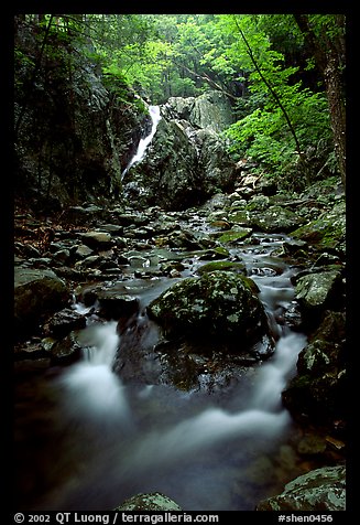
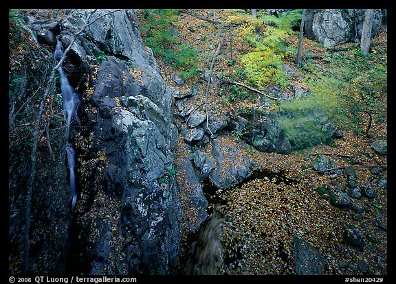
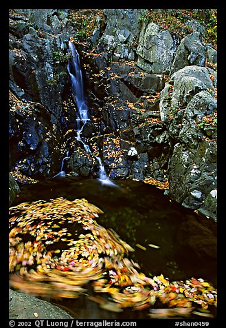
Stream Pictures, all taken during the previously described hike

