Mavericks surf contest
I’ve posted images of the Mavericks surf contest which took place this Saturday near Half Moon Bay. This was the first time I attended the event. I’ll give an account of it from a photographer’s perspective.
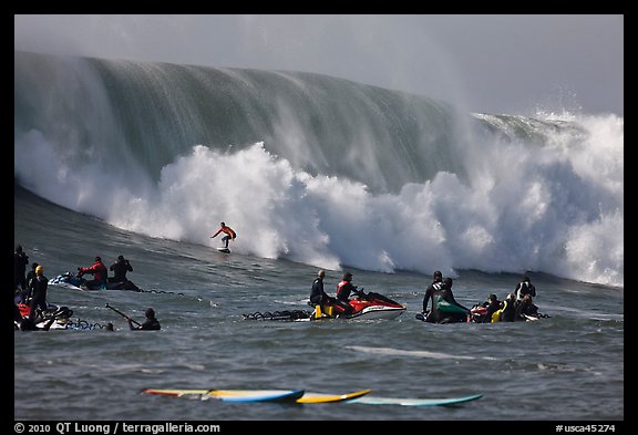
At Mavericks, an unusually-shaped underwater rock formation can cause waves to top out at over 50 feet (15m) after a strong winter storm in the North Pacific yields giant swells. Possibly the most dangerous spot in the sport, with some of the largest waves in the world, strong currents, dangerous rocks, shallow reefs, and cold water temperatures, Mavericks is a place reserved only for elite big wave surfers. Each year, an invitation-only contest is held. Since conditions cannot be predicted in advance, the two dozen selected surfers must vote on a day to hold the contest only 48 hours in advance of the event. Once the decision is made, many will hop immediately on a plane, and arrive just in time, as did this year’s winner, who flew from South Africa.
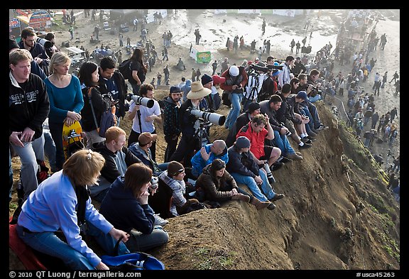
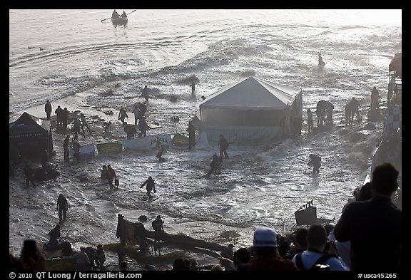
The break itself is located approximately one-half mile (0.8 km) from shore at Pillar Point, just north of Half Moon Bay at the village of Princeton-By-The-Sea. Thousands gather at the beach at Pillar Point, just content to be part of the event by watching into the direction of the break, but don’t actually see anything. The contest organizers recommend watching at home, or from a stadium with a big broadcast screen. To have a chance to watch some action from shore, you need to scramble up the muddy bluff. Arriving 15 minutes before the start of the contest, I found the crest of the bluff totally filled up. Although I was able to squeeze in, I couldn’t set up comfortably. To be certain to find a good spot, you need to arrive at sunrise. Once there, you’d need at least 600mm (on a FF 35mm format camera) for decent images, as well as good visibility. In the early morning, the atmosphere was just too foggy on that Saturday for any useful images of the contest from the bluff. However, even without seeing any action, I was still glad that I was up there rather than down, since a couple of rogue waves washed over the seawall, destroying booths, and, as I read later, injuring a dozen of spectators, reminding you of the power of nature.
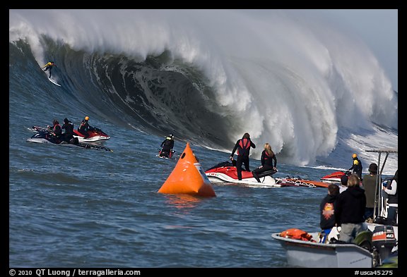
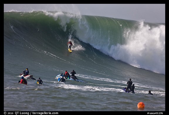
The only way to get a good view of the action is to ride a boat to the shoulder of the break. That’s how the great photos that you see published in the media are taken. The best option would be to ride the official media boat, however, without accreditation from a major media source, getting on it is a matter of luck. I wasn’t lucky. After waiting in vain for a stand-by opening, I walked to the beach (it took 25 minutes from the harbor to the beach, hence my late arrival at the bluff). I then walked back to the harbor, and got on a private tour boat, the Flying Fish operated by www.fishingboat.com, with an 11am departure – which doesn’t provide for the best light. The early morning boat was filled-up.
I found photographing from the boat to be hard. The Flying Fish was often too far for my 400mm lens (on FF). Moreover, there is a flotilla of more than a hundred watercraft of all sizes (from jet skis and sea kayaks to 50+ feet boats) at the observation spot, and many of them often got in the way. Presumably, the media boat had some priority. Then you are standing on a platform which is rocking wildly (those pesky waves !).You have to brace yourself in order not to hit the rail, wall, other people, or even be thrown overboard. At the same time, you have to pay constant attention in order not to miss any action, while a lot of the time nothing really interesting is happening, as this is the nature of surfing. For tight shots, you’d be carrying pretty heavy “big gun” lenses, and hand-holding them all day long. The predominant sound is not from the huge waves crashing (quite far away), but from the ballet of helicopters hovering overhead.
I did not manage to get any of the clean, spectacular surfing shots that abound on media pages, or on the websites of photographers such as Philip Colla and Jim Goldstein, where you see a lone surfer dwarfed by a wall of water. Only near the end of the runs, the surfers would be close enough, and the line of sight clear enough for such images, but the wave would have already crashed. On the other hand, the experience gave me a new appreciation of what they were able to achieve with those deceptively simple shots. My hat off to them ! I realized that there is a reason I do not photograph much wildlife on purpose (my possibly best wildlife images were obtained when dall sheep walked towards me): looking at subjects and trying to track them through a super-tele lens, is just too different from the way I normally experience the world. In large format landscape photography, I use a very wide lens (equivalent to a 24mm) for most of my work.
Since the other boats in front of mine, and my lack of a longer optic prevented me from making the images that I envisioned, I tried instead to capture the atmosphere of the contest by creating compositions that included the other boats in the foreground. Upon returning home, I noticed that none of those type of images appeared on media sites, yet they captured a reality of being there, an experience to be cherished, whether it results in great photos or not.