Lands Stripped of Protections in Bears Ears National Monument
No Comments
If you thought the reduction in size of Grand Staircase Escalante National Monument was bad, wait until you look at Bears Ears National Monument, which lost even more protections that same day of December 4, 2017. See some of the vast landscapes to be excluded from the monument.

The proclamation of Bears Ears National Monument by President Obama less than a year before, on December 28, 2016, was the last land conservation statement of his presidency and maybe his boldest and most significant. I learned from a conversation with NPS director Jarvis that this was not a coincidence. President Clinton’s proclamation of Grand Staircase Escalante National Monument during his first term had caused multiple difficulties. Reaction to Bears Ears National Monument was swift. Originally stood at 2112 square miles, it was ordered shrunk to 315 square miles by the following president, a reduction of 85%. The disrespect towards indigenous people in gutting the monument against their objections was even more troubling than the scale of the reduction.

Bears Ears National Monument is above all a cultural landscape that had been populated millennia before there was a state of Utah. The numerous structures and artifacts hidden in the labyrinth of canyons and mesas are estimated to surpass in number and density those of Canyons of the Ancients National Monument, and everything I wrote there applies here as well. The tribes hold the land sacred, not only because their ancestors are buried there, but also because they continue to find physical and spiritual healing in the land. Five tribes have connections to this area: the Hopi, Navajo, Mountain Ute, Zuni, and Ute. As you can imagine, they have generations-old differences, however, they agreed to set them apart to form the Bears Ears Inter-Tribal Coalition and petition together President Obama for the establishment of Bears Ears National Monument. This was the first native-driven national monument, and for the first time, its proclamation assigned shared management responsibilities between the tribes and the federal government. As such Bears Ears National Monument was a significant step in righting and healing the wrongs stemming from the settlement of the American West.

Map by Stephanie Smith,
Grand Canyon Trust, reproduced with permission. Despite their name, the Grand Canyon Trust has been very active in advocating for the national monuments under attack. Visit their Bears Ears page for information and frequent updates.
Bears Ears National Monument was four times larger than adjacent Canyonlands National Park. I have only begun to scratch its surface with respect to archeological sites. More about cliffs dwellings will follow. For now, I will focus on some sites tentatively removed from the original monument boundaries from where you can contemplate the region’s vast landscape.
Needles Overlook
Having just had a tire flat fixed in Moab, I was eager to stay on the pavement for at least the rest of the day. After miles of driving on the lonely flats of Hatch Point Plateau, I arrived at the Needles Overlook, located near the north end of the monument. Contrarily to what I expected from the name, it wasn’t a single overlook, but rather a rim trail on a peninsula connecting several viewpoints. It overlooked a wilderness of rock 1500 feet below, like Island in the Sky in Canyonlands National Park. The views encompassed more than 300 degrees, extending to the Needles District of Canyonlands National Park and the Colorado River, and including among lands to lose protections Lockhart Basin and parts of Indian Creek. Unlike at Island in the Sky, save for a couple of other visitors, I had the place to myself at sunset. By default, the best time to photograph a place is when its main features are front-lit. Therefore, sunset is the preferred time for photography there, since the cliffs are facing the west. They would be in the shade of the plateau at sunrise. Nevertheless, since it was almost a full moon night, I thought it would be worth it to hang around a bit and see how the moonrise would illuminate the landscape. A near full-moon night isn’t good for photographing the stary sky, but it offers the opportunity to photograph the equivalent of a sunset and a sunrise in a short interval. As I expected, at moonrise, there were too many shadows of the rim projected on the plateau. A low sun (or moon) isn’t always the best. Despite the cold, I waited for the moon to rise in the sky so that those shadows would delineate rather than totally cover the terrain at the base of the cliff. There are two more overlooks further north, Canyonlands Overlook and Anticline Overlook, but since they require a long drive on unpaved roads, I passed them over that day.


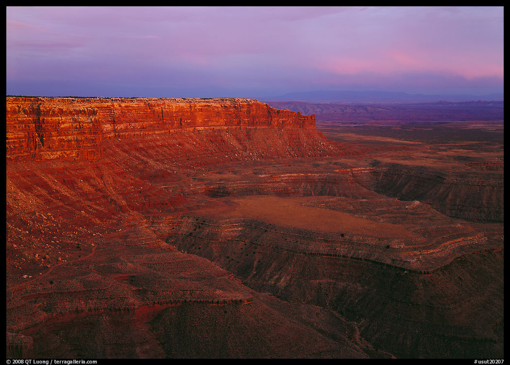
Moki Dugway and Muley Point
At the southern end of Bears Ears National Monument, driving south on Hwy 261, you see ominous signs discouraging long vehicles and warning that the road is going to turn unpaved and steep. However, although that section, called the Moki Dugway, features 180 degrees turns cut into the cliff, I found it well-graded and easily passable by any vehicle. The vista from there is immense, extending from Valley of the Gods to Monument Valley.


At the top of the Moki Dugway, a smaller unpaved road leads to Muley Point, where you find closer terrain to photograph, including the cliffs that form the edge of Cedar Mesa, and the meandering canyons of the San Juan River. More than twenty years ago, after a beautiful sunset, I found a superb camping spot right at the edge of the cliffs. When Outdoor Photographer Magazine included my image from that spot in an 2013 article profiling me (PDF) I thought that they should have used an image from a national park instead. But in retrospect, it almost looks like an anticipation of the directions I would be taking, extending my work to other public lands.


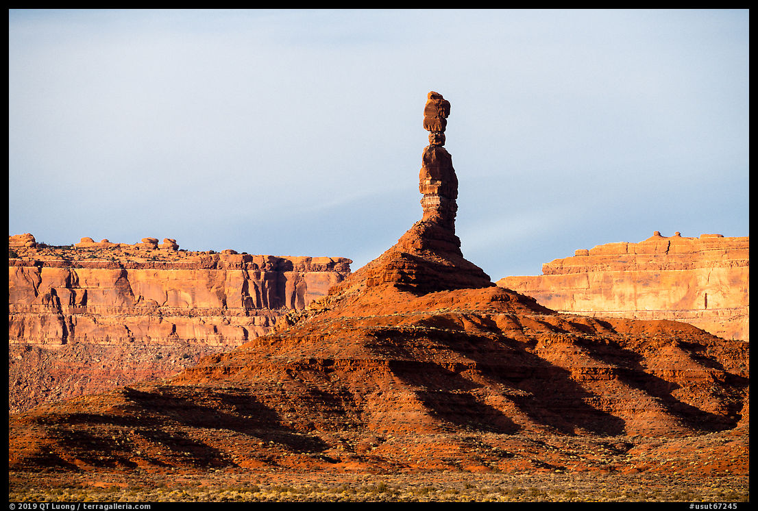
Valley of the Gods
A sandy plain dotted with sandstone buttes and spires, Valley of the Gods offers landscapes reminiscent of iconic Monument Valley. While the rock formations are admittedly not as impressive, I didn’t find the commercialization, tour groups, and streams of cars often present at Monument Valley. In addition, while Monument Valley, being located on Navajo Nation lands, is heavily regulated with limitations on where or when you can visit, you can come and go as you please in Valley of the Gods, and even find plenty of places to camp for free although there is no official designated campground. Without established trails, you can roam freely cross-country. I did not have any trouble driving the 17-mile unpaved road that traverses Valley of the Gods in my Prius, and found the most spectacular section to be right in the mid-point of that road. Entering the valley in the late afternoon, I saw only a few other cars on the entire road. The quiet, solitude, and freedom to explore make a drive through Valley of the Goods a memorable experience.


That’s some vast and beautiful natural landscapes, but on top of that, remember that Bears Ears was intended to protect a cultural landscape. I touch on this aspect in the next article about Bears Ears.

