Canyons of the San Gabriel Mountains
2 Comments
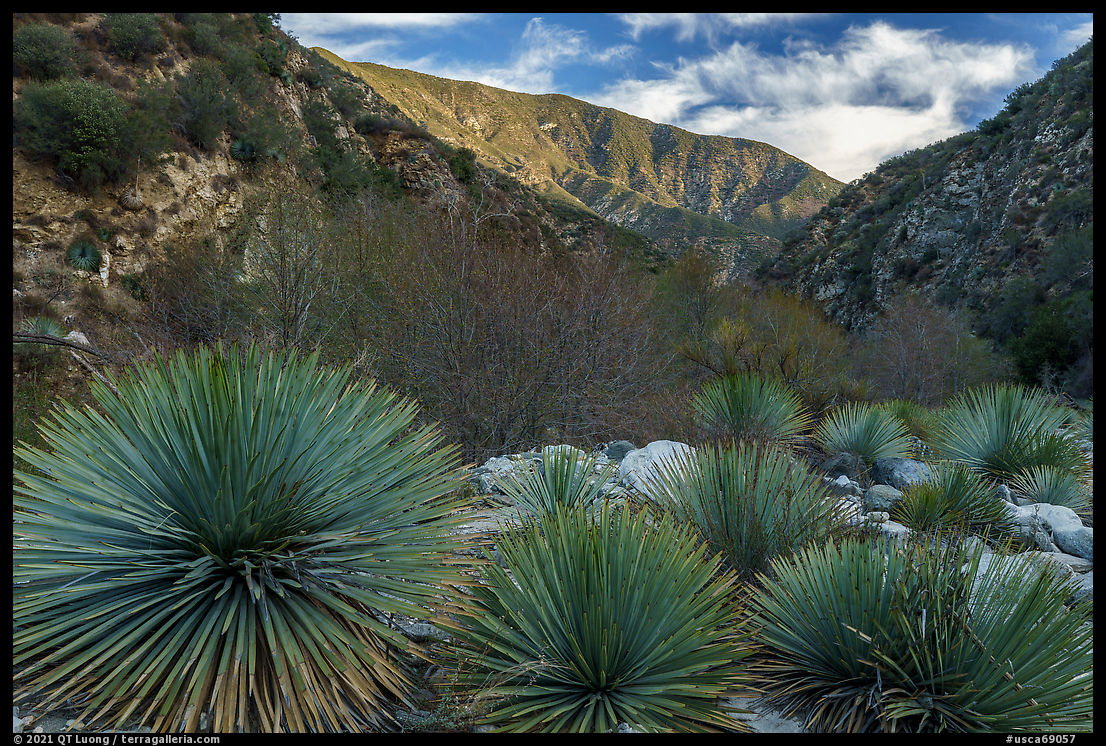
Part of Southern California’s transverse ranges running east to west, the San Gabriel Mountains are roughly divided into two parallel ranges. The front range in the south, culminating with Strawberry Peak (6,164 ft) and San Gabriel Peak (6,161 ft), borders the Los Angeles Basin. The back range in the north includes a chain of peaks above 8,000 ft climaxing at 10,068-foot Mt Baldy. It is best to hike the lower elevation front-range trails during the cooler months and the higher elevation back-range trails during the warmer months. Winter snows close off the high country to hiking, and the higher sections of CA-2 can be closed. During that time, the lower elevation hills are green and inviting.
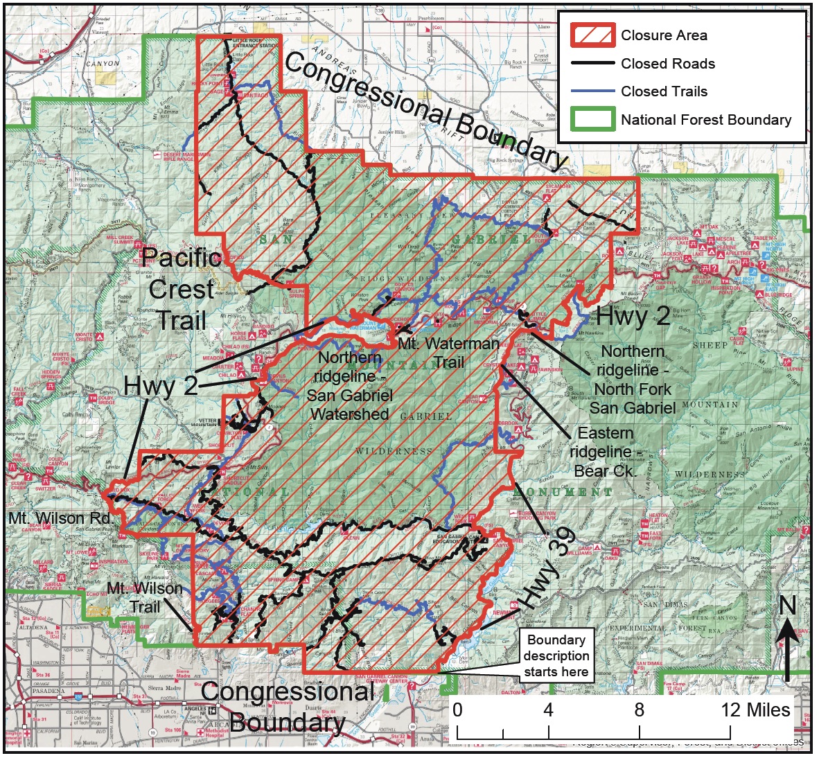
Last year, the virus outbreak prompted a stay-at-home order in California. After it was lifted, I explored a few high elevation areas, including a hike up Mt Baldy. But on that trip, it was just too hot to enjoy hiking the lower elevation canyons. Then, the late summer and autumn were plagued with some of the worst wildfires in the area’s history. They threatened to take out the Mt Wilson observatory and closed down large portions of the monument. In the winter, a Google search for “San Gabriel Mountains National Monument” indicated that the area was closed. With only a couple of months before Our National Monuments is set to go to print, I was eager to hike some lower-elevation trails to round up my explorations of the area. Bryan Matsumoto from La Nature for All pointed out to the map below, which indicates that closures were limited to the central portion of the monument. Fortunately, a few of the hikes I had planned to do were located outside of it.
Switzer Falls
Despite their dry appearance, the San Gabriel Mountains conceal more than 65 waterfalls. The moderate hike to Lower Switzer Falls (3.6 miles round-trip, 650’ elevation loss) is one of the most popular in the front range. I came on a weekday morning, when I drove into the parking lot, it was cold and raining, yet I was lucky that a car pulled out because the lot was full. It wasn’t the large lot at the Switzer Picnic Area since the road leading to it was closed (maybe because of the virus) but rather the one next to CA-2, requiring an additonal walk on the closed road.The hike offers varied sights besides waterfalls: the shaded murmuring creek of Arroyo Seco, historic resort ruins, and the impressive gorge of Bear Canyon from an airy section of trail. Starting at Switzer Picnic Area 10 miles up CA-2, the established trail ends at Lower Switzer Falls, a two-tier drop of about 30 feet into a beautiful pool four feet deep. Unfortunately, graffiti marred the walls. I subsequently learned that the time of my visit marked a high (low?) point for graffiti. USFS workers and teams of volunteers normally spend a lot of time to clean up those. However, because of COVID-19, the USFS had not allowed them to operate.
After scrambling smooth rocks and a tiny ledge, I stepped into a lush and narrow canyon that I followed for less than a half-mile. Past a sizeable log jam, 50-foot-high Upper Switzer Falls presented itself suddenly. It struck me that despite the main hike’s popularity, the upper canyon felt so little used. Adventure is just around the corner.


East Fork of the San Gabriel River
The mountains are the most prominent component of the monument, but canyons in between are equally impressive. I found the East Fork of the San Gabriel River hike (10 miles round-trip, 900’ elevation gain) a fun way to acquaint myself with one of those monumental canyons. The year-round flowing waters of the San Gabriel River’s largest headwater sustain a delightful river habitat. In early March, temperatures were just right, and new leaves of trees growing along the river added a touch of tender green that contrasted with the desert environment.I ended up crossing the river many more times than the necessary minimum of four times (each way), sometimes wading in thigh-high water, other times balancing myself on rocks and branches. Some people pack a pair of sandals to avoid getting their hiking boots wet, but since it wasn’t too cold, I thought that after the experience of Paria Canyon, it wouldn’t be a big deal to hike in wet shoes, and it wasn’t.
Although the hike is possibly the most popular in the monument, the main trail isn’t always straightforward. I managed to get lost and put myself in a precarious position on such a popular trail. Path crisscrossed all over the place. At one point, I followed the wrong one along the river, instead of climbing up steeply on the left side of the canyon. I was hoping that it would provide an alternative route to my destination, but when it was clear that it wasn’t leading me there, instead of backtracking all the way, I looked for a shortcut. I could see the trail above, and scrambling up the 45-degree slope looked straightforward enough, but it turned out quite slippery and unstable, and if not for mountaineering skills, I don’t think I would have made it.
Even if the hike ended nowhere, it would still be enjoyable, but it ends at a notable destination, the Bridge to Nowhere. That is the nickname of a grossly out-of-place, elegantly arch-shaped, 120-foot-high bridge spanning a steep gorge. The road for which it was built in 1936 washed away two years later and was not reconstructed. On the way back, I had a much easier time staying on the trail, especially since there were many markers painted on the uphill side of the rocks, therefore visible only when hiking out. It struck it as odd, since one’s first acquaintance with the trail must be on the way in.
Although located within Sheep Mountain Wilderness (free permits available at the trailhead), the bridge sits on a private enclave. That helps explain, why, despite being surrounded by designated wilderness, the Bridge to Nowhere is the only place in Southern California with a commercially licensed bungee jumping operation – the oldest in the USA as it’s been around since 1989. I didn’t see any of the circus since I hiked on a weekday. But I could imagine a scenario in which base jumpers inexperienced in hiking are escorted by staff on the way in, and then would hike out by themselves after their jump, therefore finding the trail markings useful on the way out.


I hope to get to California again sometime soon. Your images of it are quite inspiring and deepen that desire. Always enjoy your work.
I wish I could visit there someday. But the pandemic is getting worse day by day. I love to see waterfall and I like to hear the waterfall sound.