Alternative Icons in Death Valley
3 Comments
Death Valley National Park is defined by its sand dunes, playas, salt flats, and badlands. Last April, I spent a few days in the park and photographed each of those iconic features, however not at the classic locations usually associated with them. I never saw another photographer. Read this post to learn about the alternative locations I visited.
Salt pan: the Cottonball Basin
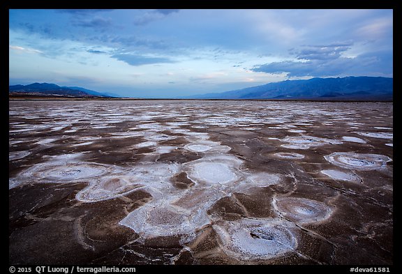
Death Valley is the only National Park to feature extensive salt flats. They are formed there because, in this desert, the rate of water evaporation exceeds the rate of water precipitation. The salt pan around Badwater and Devil’s Golf Course is the largest and most well-known. However, last April, I found the whole Badwater area to be brown and dirty-looking. The salt pan along the West Side Road wasn’t much better. To produce beautiful polygons, the basins need to be flooded, but the last time this happened was 2010.
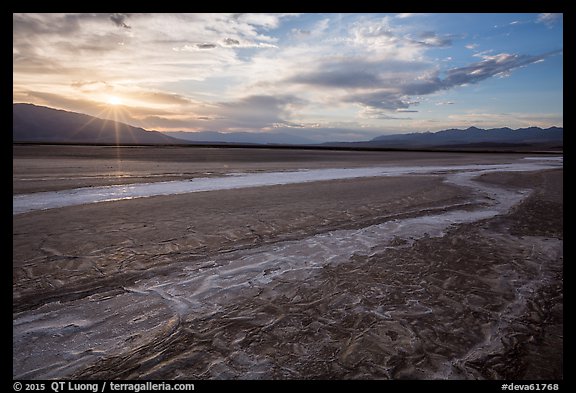
The Cottonball Basin, being close to Salt Creek (the wettest area in the park), fared a bit better. That’s the only place where I could find decent salt formations, although not polygons. I drove about 5 miles north from Furnace Creek on CA-190, parked on the side of the road. Starting about an hour before sunset, I hiked cross-country towards the west for approximately a mile, heading towards the glistening areas in the distance. I was careful to avoid wet areas in order to avoid leaving noticeable footprints, and I hope that if you visit, you’ll do the same!
Mud Playa: the Panamint Valley
Playas are dried lake beds. Many exist in Death Valley, while they are quite rare in other National Parks. The most famous is the Racetrack, because of its moving stones, but it is quite out of the way. Recent road conditions make tire punctures much more likely than in the past when I drove there four times with various passenger vehicles, including a Toyota minivan.
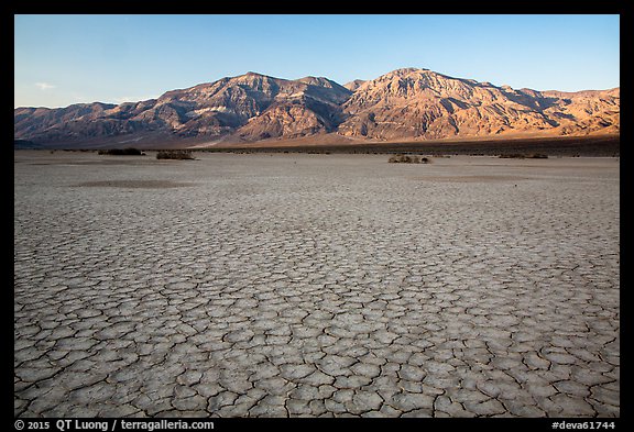
The Panamint Playa is quite extensive and much easier to access. It is bisected by CA-190 between miles 3.5 and 4.2 east of Panamint Springs Resort and extends for many miles in both the northern and southern directions. Late afternoon lights up the Panamint Range. I parked at mile 4 and wandered on the north side.
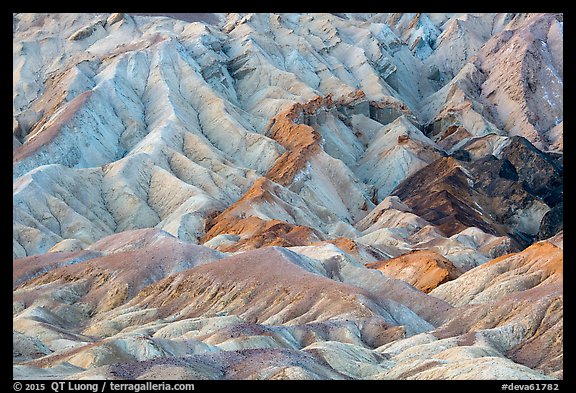
Badlands: Twenty Mule Team Canyon
Zabriskie Point being an icon (see my tip on finding a better viewpoint), the platform is crowded at sunrise.
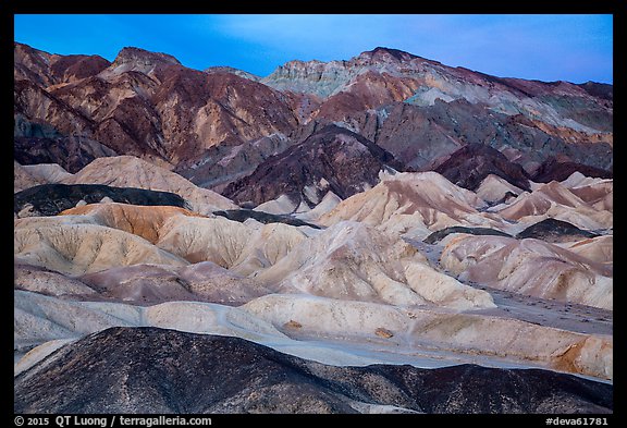
Nearby Twenty Mule Team Canyon feature badlands that easily rival those found at Zabriskie Point. Unlike at Zabriskie Point, you are not limited to a platform and its surroundings, but instead drive a 2.8-mile one-way dirt road (passable by any car) which offers you a variety of viewpoints. I saw only a couple of other cars from dawn to well after sunrise. The entrance of the road is 3.6 miles south of CA-190 from Zabriskie Point.
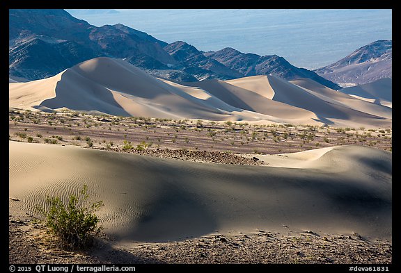
Sand Dunes: Ibex Dunes
Dead in the center of the park, conveniently located near Stovepipe Wells, the Mesquite Flat Dunes are one of the prime attractions of Death Valley for photographers and non-photographers. The popularity makes it very difficult to escape footprints and to exclude people walking on ridges. By contrast, I didn’t see a single other car at the Ibex Dunes, nor did I notice any footprints other than mine. I still managed to ruin a good potential composition by trampling a ridge! However, this was the least of my worries, as I’ll elaborate on in the next post, which will also give more details about those dunes located in the south-east corner of the park.
Death Valley National Park is so large that it is easy to find the same subjects that people photograph at iconic locations at those, and other out-of-the-beaten path locations that let you make your discoveries.
Is there a little-known location in Death Valley that you’d like to share?


Couldn’t help but notice that no one wants to give away their ‘secret’ spots! I’ve been to DV 2x and soon will be going back. Having fun exploring your blog! You’re Ibex Dunes story resonates. I got hit by a flash flood on I 190 two years ago at night…Makes for a good story but…
For Cottonwood Basin, you said go about 5 miles north of furnace creek and walk about a mile to the west. I was wondering if you could be a bit more specific on the location. I’m not sure if you mean 5 miles from say the main area with the post office etc or the town limits. I’d love to see those cool formations, but I’m pretty risk averse and don’t just want to go hiking into the desert not knowing pretty much where I am going.
It does not matter since (a) the area with salt patterns extends for at least 5 miles along the road (b) Precise locations for the most interesting formations vary from year to year, and even within a year. If you don’t enjoy extensive scouting in the desert, this might not be the best site for you.