Terra Galleria Photography

Photo Spot 58: Kobuk Valley National Park – Great Sand Dunes

Kobuk Valley National Park is located in Northwestern Arctic Alaska, entirely above the Arctic Circle. It has the distinction of being the least visited of the 58 US National Parks.

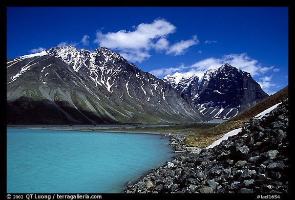
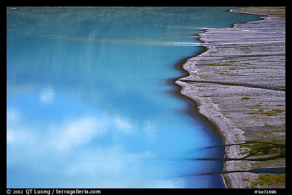
Following our summer 2001 trip to Lake Clark National Park, the expedition to Kobuk Valley National park in 2002 was the first wilderness trip that Lanchi and I undertook after our wedding. This started by driving to Healdsburg, a town near the Russian River which is one of the most popular river rafting runs in California. There, we rented an inflatable canoe from SOAR. Their boats have the reputation of being rugged – you don’t want to get a leak in the middle of the Alaska wilderness – yet, when deflated they collapse to a small size, making them transportable by plane.

Armed with the SOAR boat, we flew (using again Alaska Air miles) to Kotzebue, the largest Eskimo community in Alaska, situated just north of the Arctic circle, on the coast of the Bering sea. From there, we boarded the mail plane to the Eskimo village of Ambler, situated East of the park. A kind villager offered us a four-wheeler ride from the airstrip to his family’s stand of drying white fish (see here) next to the river. We inflated our boat, and soon we were off for a week-long, hundred miles river journey down the wide Kobuk River through Kobuk Valley National Park, to the Eskimo village of Kiana, West of the park.

Floating downstream, we were hoping for an easy and relaxing trip, but the river was so placid that we ended up having to paddle all the time a boat that wasn’t tracking particularly well, probably because it is rudderless. Mid-way through this journey, as the night was approaching, a torrential shower came out of nowhere. We debated pulling to shore to seek shelter, but instead opted to continue, since we thought we were close to our objective. As we were getting soaked to the bone, we felt relieved to reach a characteristic wide bend of the river. As the rain started to ease, we set up camp on a bluff, planning to hike the next day. The next morning started by building a fire. After a few hours, all of our clothes, that we held up to the fire, were dry.

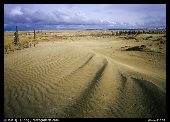
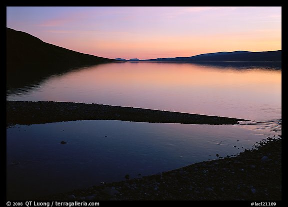
We hiked for a couple of miles, and at last set foot on the Great Sand Dunes, the most distinctive feature of the park. The unexpected sight is the largest dune system in the Arctic, a relic of the last ice age, when glaciers deposited sand there. The huge dune field was reminiscent of the deserts, but many clues pointed to its Arctic location.

I set up the large format camera. I looked for an angle where the ripples of the dunes would have the most contrast, eventually settling for a composition with a diagonal ridge line pointing to a group of black spruce trees, balanced by a more distant group of spruce trees – one of the clues we were in the Arctic. Because of the cloudy skies, the light wasn’t the best. Nevertheless I clicked the shutter in a celebratory mood. This was the moment I had been waiting for.

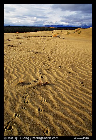
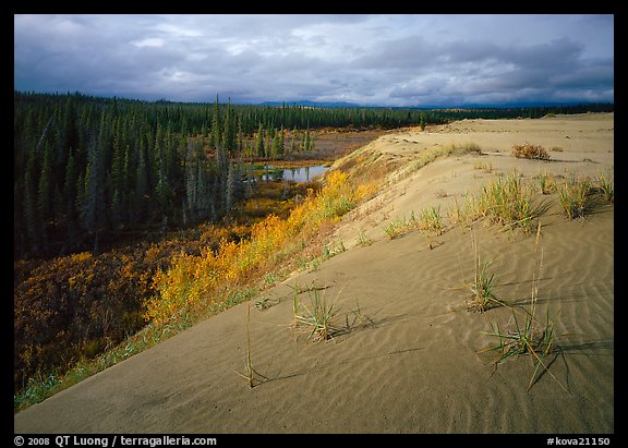
Next, I focused on the caribou tracks – another of the Arctic clues – that were crossing the dunes. There was still one element of the Arctic dune environment that I almost missed, the curious “reverse oasis” experience, where I was standing on a huge island of sand surrounded by lush vegetation in fall color as far as I could see – we had timed our trip on the last week of August for the foliage, as well as for the beginning of the caribou migration. Wandering near the edge, I found a spot where the two elements merged gracefully. At this point I had only one unexposed sheet of film left with me, so despite of all these years of experience, I proceeded even more slowly than usual, taking extra precautions not to make a technical mistake that would ruin the film.

Once I exposed it, and although the trip was far from being over, I felt that the last item on a decade-long to-do list could finally be checked off. Kobuk Valley National Park was the last of the 58 National Parks that I needed to visit in order to complete my project to photograph all of them in large format. The goal had been attained, but what I cherished the most was the journey. It continues to this day.

View more images of Kobuk Valley National Park
View more images of Great Kobuk Sand Dunes

Penang, Malaysia

Because of the weather in Ko Phi-Phi, I decided to shorten the stay in Thailand and spend more time in the cities of Malaysia. Rainy weather isn’t great for photographing (or even enjoying) tropical islands, but it doesn’t matter that much in a city, if you are concentrating on architecture and people.

The next stop would be Penang. I had initially planned to travel by train down the Malay Peninsula, but after a bit of research, I concluded that for this leg of the journey, taking a mini-bus would be much simpler. To journey by train, you’d have to find transportation from the Krabi passenger boat terminal to Krabi town, then catch a bus to Hat Yai. From there, get on the train to Butterworth and then take a bus or ferry to Penang. Instead for about 800 Baht ($26), a mini-bus would pick up us at the pier, and then drop off us right at the Love Lane backpacking district in Penang. By now, I wasn’t surprised anymore when the mini-bus went around town to pick up additional passengers, even when it appeared to be full. I was just a bit concerned for the passenger who was sitting on the floor for such a long journey, but he actually hitched only a short ride to a bus station. The 11 hours trip was broken up by a lunch stop, a change of bus in Hat Yai (during which we were provided immigration forms for Malaysia), and the actual crossing of the border, where we had to disembark and carry our luggage for inspection. No advance visa is required of US and ASEAN citizens for a short stay in Malaysia.

By the time we arrived in Penang, it was quite late. The “SD Guesthouse” listed on the Lonely Planet had gone out of business, and most of the Love Lane hotels had filled up. After settling for a cheap Chinese hotel (that I’d call a dive, although the owner was friendly) for the night, we moved the next day to the Banana Guest House since my cousin didn’t like having to go in the courtyard downstairs for the bathroom, and I wanted a wireless internet connection to stay in touch with family through Facetime.

Even though it rained a lot, I found the historic district of Georgetown (the main city on the island, which for most visitors is Penang) wonderful to explore on foot, as it was compact and full of historical buildings, ranging from mansions, to assembly houses and temples. I noticed more diversity than in any other place I’ve visited in Asia, with British Colonial, Indian, and Chinese influences. Buddhist, Muslim, and Hindu religions appeared to co-exist peacefully. Highly recommended !

View more images of Georgetown, Penang

Photo Spot 57: National Park of American Samoa – Siu Point, Ta’u Island

The National Park of American Samoa is located in the South Pacific, in the Southern Hemisphere, right in the center of Polynesia, making it the most remote of the 58 National Parks. Its slightly different name (not “American Samoa National Park”) reflects on its status: The National Park of American Samoa is situated on a US Territory, its lands are all leased from Samoan villages which are the true landowners.

The distance to the continental US is certainly the reason the National Park of American Samoa is the second least visited of the 58 US National Parks. To get there took me ten hours of flight from California, plus a stop over mid-way in Hawaii. If it was closer, I’d expect that park to be a popular unit. It is one of the most beautiful parks, graced with magnificent sand beaches and pristine coral reefs, bordered by tropical rain forest islands ringed with impressive cliffs.

The park comprises sections of three islands, Tutuila, Ta’u, and Ofu. The later two are part of the group of Manu’a islands, a half-hour flight from Tuituila, the main island. Since it was such a long trip to get there, I made sure to visit all three of them. The least visited island on that most remote park is Ta’u Island, where the Park doesn’t have any facility. As camping is not allowed and no commercial lodgings were available, I made arrangements for a home stay with a Samoan family with some help from the NPS office in Tuituila.

As I disembarked from the small prop plane and walked to the tiny office, my host had no problem finding me: I was the only visitor. I loaded my gear on the back of his pick-up truck amongst a jumble of pandanus leaves and coconut hulls. We drove on through a beautiful coastal road which was totally empty, and arrived at Fiti’uta, a village consisting of maybe a dozen houses and the traditional communal Fale.

The Samoan culture is Polynesia’s oldest. The first people on the Samoan islands came by sea from southeast Asia some 3,000 years ago. However, Samoans believe their God Tagaloa created the first man and woman on Ta’u and that all people descended from them. Ta’u is also the site of Margaret Mead’s landmark study for Coming of Age in Samoa (1928) which was for forty years the most widely read book in the field of anthropology. My host’s wife had prepared a great looking dinner, but since I am a vegetarian, I had to content myself with taro roots. The next morning, my host drove me past Sau’a, that mythical site of the creation of humanity according to Samoan beliefs. He dropped me at the end of the dirt road, named Siu Point. I would not see another person there.

The coast was the wildest I had ever seen. After my first glimpse of it, I tried to hike along the shore in order to get closer to the sea cliffs that I saw in the distance, which I read were the tallest in the world. However, I was making slow progress, as I had to hop from boulder to boulder with my heavy backpack. The black, volcanic boulders were quite sharp. Seeing that the perspective did not change significantly, I turned back in order not to be late for the evening pick-up.

I had initially planned to stay only two days on Ta’u before flying to Ofu, but my host told me that the flight for the next day had been canceled due to an incoming storm. Since there was only a flight every two days, this meant two more days on the island. At the time of my visit, information about Ta’u was scarce, and I was aware of the trails to Laufuti Falls or Lata Mountain. My understanding was that the other parts of the National Park on Ta’u consisted of a roadless jungle inaccessible without a guide with whom I would have needed to make arrangements with in advance. Therefore, all my host could do for me was to drop me off again at Siu Point. Past the disappointment of having to shorten my stay on Ofu, and revisiting the same spot, the prospect of a tropical storm was actually quite exciting, so I prepared myself for a wet day, since there is no shelter there, and I would be on my own for the day.

Fortunately, it poured only for brief moments, that I waited by sitting under my umbrella. The rain actually proved a welcome respite from the tropical heat. In the end, it is as if the Polynesian gods chose to reward my perseverance by rainbows, a show of big crashing waves under a dark sky, and then dramatic light at sunset. Just as the dark clouds were starting to yield an intense shower, I saw the headlights of my host’s truck. On the way back, as it rained so hard that it was difficult to see the road through the glare of the lights, I could see his surprise when I told him that I had a great day.

See more images of American Samoa
See more images of Siu Point

Photo spot 56: Cuyahoga Valley National Park – Kendall Lake

Cuyahoga National Park preserves a small section of rural landscape along the Cuyahoga River between the two large cities of Akron and Cleveland in Ohio. Like for Black Canyon of the Gunnison, I visited Cuyahoga late because it had just been designated a National Park the year before.

At first, expecting the traditional terrain of a National Park, as I drove the length of the park, I was left wondering where the National Park actually was ! In many other National Parks, the hand of man is present in a subtle way, even if the landscape looks pristine at a first glance. In Cuyahoga Valley, the impact of man was anything but subtle. The area that I crossed had many roads, agricultural lands, recreational parks with lots of facilities, a golf course. Private homes were even all over the place. Many portions of my adopted city, San Jose CA, are more wild. I eventually drove past a “Cuyahoga National Park” entrance sign, so I had to tell myself “that’s it”.

After I got past my expectation, I began to understand the significance of the place. By the middle of the 20th century, it was a dump. Once I realized that this once heavily polluted valley could have been restored so that there were now plenty of pockets of natural beauty, I began to appreciate them more.

One of the largest lakes in the area is situated within Virginia Kendall Park, in the eastern section of the park, southeast of the small town of Peninsula. The 13 acre Kendall Lake was created by damming the Salt Run creek (a tributary of the Cuyahoga River) by the Civilian Conservation Corps in 1935, part of FDR’s New Deal extensive program of public works. Rehabilitated in the early 2000s, the dam keeps Kendall Lake filled with water and controls the outflow to Salt Run.

Following a mile-long loop trail, I walked several times around the shore of Kendall Lake, at different times of the day, on different days, experiencing different weather. Surrounded by a varied mixed woodland, and cattails, home to beavers and Canada Geese, the modest body of water offered much more than I thought it would. I reflected on the fact that I had to travel across the country to do such work, when I could have found many places similar to this close to the city where I live, and investigate them in even more depth. It might be all inside your mind, but it’s still necessary to take the journey to unlock it.

See more images of Cuyahoga Valley
See more images of Kendall Lake

Happy Year of the Rabbit

As a multicultural family, we get to celebrate twice as many occasions ! Today is the lunar new year. We wish you and all your loved ones a year of the rabbit (cat for the Vietnamese !) full of happiness, health, prosperity, and success.

Ko Phi-Phi Island, Thailand

After Railey, my next stop in southern Thailand was Ko (island) Phi-Phi. I catched a long-tail boat ride at Railey East to the small pier of Ao Nammao. The tour operator with whom I had booked the trip sent a mini-bus – late by almost an hour and again packed to the gills – to shuttle us from there to the shiny Krabi passenger terminal, where we boarded a larger vessel for the hour and half crossing.

From the boat, we saw plenty of barely developed beaches, with just a few bungalows nearby, but by contrast Tonsai Village surprised me by being a wall-to-wall patchwork of tourist-oriented businesses. In particular, i had never seen as many dive shops before, offering instruction in any possible language. Yet the atmosphere was relaxed, with not a single motorized vehicle in sight.

The waters, crystal clear, must have been a stunning sight in good weather, when the sun could penetrate them to reveal their turquoise hues, but unfortunately the rainy weather continued. In those conditions, I thought it wouldn’t be worth it to take a boat tour, and instead wandered around with an umbrella. My most interesting discovery was a small muslim cemetery (at the bottom of this page), which, with its low profile graves, was unlike any of the cemeteries that I have seen before.

However, since staying for hours in a cemetery is no way to spend a tropical island vacation, despite the cloudy weather, I headed to the beach, which was lined up with long-tail boats.

The long-tail boats are an iconic watercraft in this part of the world. These ingenious boats use a common automotive engine, mounted on a turret which can rotate through 180 degrees, allowing steering, and also swivels up and down to provide a “neutral gear” where the propeller is outside of the water. The propeller is mounted directly on the driveshaft (with no additional gearing) through a long metal rod of several meters (see here) giving the boat its name. Since there are no roads on Phi-Phi Island, long-tail boats are the means of transportation for locals and tourists to destinations outside Tonsai Village.

Although the scene lacked brilliant colors, there was a sense of tranquility that I tried to capture. As I lingered for a long time there, I noticed that despite the overcast conditions, the light and pastel colors changed in a subtle way as the hours passed. The difference was enough to yield different images that feel different to me, even with a similar composition. Which one do you prefer, and why ?

View more images of Ko Phi-Phi.

Photo Spot 55: Katmai National Park – Brooks Falls

Katmai National Park is located near the end of the Alaska Peninsula, in the middle of which is situated Lake Clark National Park. Although further from Anchorage than Lake Clark National Park, Katmai sees a slightly larger visitation, 9000 annual visits versus 6000, making it the fourth less visited National Park. Katmai was created in 1918 (as a National Monument) to preserve the Valley of Ten Thousand Smokes, a forty square mile, 700 foot deep ash flow deposited by Novarupta Volcano, whose eruption in 1912 remains the largest recorded in modern times.

Nowadays, most visitors come for the spawning grounds of Sockeye salmon, and the resulting brown bear population, both world’s largest. Katmai stands out as one of the few places in the world where humans can coexist right besides the bears in their own natural habitat. Although as a landscape photographer, my main goal was to explore the Valley of Ten Thousand Smokes, I could not miss the opportunity to see and photograph the bears. I planned my visit to coincide with the peak of the salmon run, at the beginning of July. This is the only time in the year to try and capture images of a brown bear catching a salmon flying mid-air by just opening its mouth. Later in the years, the bears may look more fat and happy, but the salmon are no longer swimming.

There is only one place to witness the event, Brooks Falls, where thousands of salmon try to jump the four-foot tall wide chute in a predestined journey to spawn at the place of their birth. Perched on the brink of the falls, and in the water below, the bears wait in anticipation of the coming feast.

To get there, I flew with a Alaska Airlines jet flight to the aptly named outpost of King Salmon. Although a flight from San Francisco to King Salmon (via Anchorage) costs more than $800, it can be booked for just 25,000 miles collected with the Alaska Airlines VISA card – one of the best reward programs out there. Katmai Air operates scheduled 20 minute flights of float planes from the river in King Salmon to Brooks Camp for about $200 round-trip. The flights are timed to coordinate with the arriving and departing PenAir and Alaska Flights. I was told that if your flight arrives late, the float plane won’t leave without you, and if it gets busy, they’ll just add one more flight. The main logistics difficulty is therefore to book a place to stay in Brooks camp during the salmon run window of late June-early July. The small lodge often sells out a year in advance. You can’t camp near the Brooks River except at the Brooks Camp National Park Service campground (which charges only a modest reservation fee).

When I arrived there, after attending the mandatory ranger briefing, I quickly understood why. The campground was surrounded by an electric fence to keep the bears out (like the dinosaurs in Jurassic Park !). As an additional precaution, all food and scented items had to be stored in a shed. In the park, the bears have the right of way. If a bear decides to take a nap on the trail, no visitors can come within 50 yards (100 yards if it is a mother with cubs) creating what is known locally as a “bear-jam”, which can delay by hours your movements in this otherwise small area. The delivery of our luggage had also been delayed by a bear, as there is only one path between the float plane landing site and the campground. Everything in Katmai revolves around bears.

Katmai has the world’s largest population of protected brown bears, more than 2000. With that many bears roaming around, encounters between humans and bears are inevitable, but since the bears are well fed from the salmon, with some rules a peaceful coexistence has been attained. The rules are simple: don’t get near them, don’t surprise them and don’t encourage them to see humans as a source of food. They have worked well, as no one had ever been killed by a bear at Brooks Camp. Credit for this must go to the Park Rangers, who spend most of their time “directing traffic” to keep people a safe distance from the bears, so that they don’t become too habituated. I though about other places where bears had been exterminated. Disharmony between bears and humans were not the bears fault. It was a human inadequacy brought about by our fear and distrust of them.

The only fatal bear attack that occurred in Katmai National Park was the predatory mauling of Timothy Treadwell and his girlfriend in 2003 on a remote section of the coast. As documented in his own book “Among Grizzlies” and then in the Werner Herzog’s 2005 (agenda-driven) film “Grizzly Man”, Treadwell spent 35,000 hours spanning 13 summers living alone amongst the bears, sometimes even touching them, without any previous mishap. Treadwell’s behavior with the bears was unusual and controversial, but he never encouraged others to approach bears as he did. It is tragically ironic that his death threatened to undo his and others work in trying to convince people to adopt a kinder attitude against bears.

I proceeded on the trail between Brooks Camp and Brooks Fall. It is only one mile-long, but I had to wait one hour for a “bear jam” at the floating bridge. After the bridge, the trail entered a forest covered in a lush carpet of mosses. I eventually arrived at the final observation deck, accessed via a series of locked gates – serving to keep the bears from coming up behind you on the decks.

A ranger took count of people, allowing only 40 at a time, placing a one hour limit on viewing and a keeping track of a waiting list when more than 40 were around. The platform provided a stable platform for my tripod, but it wasn’t possible to spread the its legs, and sometimes the view was obstructed. As slightly unpleasant as the crowding was, it reflected an interest in bear viewing that I thought could only be more positive than bear hunting, and a shift in attitude from fear to respect. Anyways, wildlife viewing was so spectacular and the bear behavior so captivating that I soon forgot about these inconveniences. It was like in a National Geographic documentary.

The dozen bears at the falls paid no attention to the people on the platform. They were close enough that my 100-400 f4.5-5.6 lens framed then tightly – although not as tightly as in the famous by Tom Mangelson or Galen Rowell that focus on the fish catching. In those days of slide film and low ISO, I wished I had a faster lens in the late afternoon, when the light improved (the platform faces North East). When the visitors who had came for a day trip left, the platform regained its tranquility. In the evening, as the light became too dim for photography, I just watched. On the way back to camp, the portion of the trail in the dark forest felt intimidating at dusk, as I could sense many bears lurking in the shadows, and was expecting one to step up in front of me at any moment. My close encounter with a bear would happen in opposite circumstances, but this will be the subject of another post…

See more images of Katmai National Park.
See more images of Brooks Falls.

Railay, Krabi Province, Thailand

I am mostly known for my work in the US National Parks. However, one of the reasons I came to appreciate them so much is that I have traveled in many corners of the world. This gave me a wider perspective which made it possible to understand how unique they are. This website started ten years ago with images of Asia, so it is fitting that in the months leading to its 10th anniversary I will post mostly new images of four countries in South East Asia from a recent month long trip.

Last December, I traveled for half a week in the Krabi Province of Thailand. I purchased in Bangkok a combined sleeper train and bus ticket for about $42. Train travel by night is environmentally friendly, and saves time as well as a hotel night. Since the bus ticket was purchased at the train station, I expected a comfy government bus, so I was surprised to ride from Surat Thani to Krabi on a mini-bus, packed solid with other backpackers. In addition, instead of arriving in town, the mini-bus dropped us at a tour agency located far from the town center ! After another half-an-hour mini-bus ride to Ao Nang, and then a fifteen minute hop on a long tail boat, I arrived in Railay, a peninsula accessible only by boat, where the most dramatic vertical limestone cliffs of the area drop right onto beaches.

Although December normally marks the end of the rainy season on the Malay Peninsula, I was greeted by a drizzle. In hot places I am familiar with, such as the American Southwest or Vietnam, the rainy season is a good time for photography. When it is not raining, the sky is clear, and the rain itself is preceded by dramatic skies and storm light. Not in Southern Thailand. I was disappointed by a mostly overcast sky. However, although scenic images wouldn’t be too successful (except at twilight), there were still plenty of interesting scenes to work with.

See more images of Railay

Photo spot 54: Lake Clark National Park – Turquoise Lake

Lake Clark National Park, situated on the Alaska Peninsula, does not include the superlatives of the other Alaskan parks such as highest or northernmost mountains, largest icefield or glaciers. Instead, the park preserves a supremely varied wilderness where all the geographical features of Alaska can be found in a relatively small area.

Maybe because the lack of famous features, Lake Clark National Park is one of the three least visited National Parks, with less than 6,000 visits in the year 2008. The other factor contributing to this low visitation is certainly the lack of road access, which makes travel relatively expensive, since one needs to fly with small planes. But isn’t it the case of most of Alaska ? As we will see soon, accessing a place that at first seems so remote and un-travelled is not that expensive nor difficult.

For my trip there, I was accompanied by my fiancee and her sister. While both of them are experienced backpackers, they had not traveled in demanding wilderness conditions before. I thought that Lake Clark National Park would provide us with an easy adventure – for an Alaskan park. This series may sometimes give the impression that many of the most interesting places are accessible only to experienced outdoorpersons. In fact, while I go the extra mile to capture a photograph (for instance climbing a mountain), places that provide a relatively similar experience (the foot of the mountain) can often be reached with only a moderate amount of skill and effort.

For our first spot in the park, I had chosen the head of Lake Turquoise, based largely on the inclusion of a photograph of that lake in the “National Geographic guide to the National Parks”. I’d like to think that my own photographs would similarly inspire others to explore. Speaking with the Park service rangers, as well as the air taxi, confirmed that the area provided pleasant hiking. Arriving in June, we would enjoy the best stretch of weather on the Alaska Peninsula, as well 20 hours of sunlight. The alpine flowers on the tundra would be in bloom. The only problem would be that mosquitoes peak as the same time as wildflowers !

There are plenty of flights to Anchorage, as the northern location of the city has made it an international air hub. From there, the four of us boarded a commuter plane for a one-hour, regularly scheduled, flight to the small (pop 100) community of Port Alsworth, located inside the park. In 2001, the round trip cost was $300 per person with Lake Clark Air, which we found to be friendly and reliable. Upon arrival at Port Alsworth, we all piled up on the “airport shuttle”, a ATV pulling a wooden trailer in which we sat, our backpacks providing the cushioning. This took us the short distance from the dirt airstrip to the shore of Lake Clark, where we loaded our backpacks onto a floatplane.

Backcountry air charters are expensive because to get you to your destination, and then pick you up days later, the pilot has to fly a total of four flight segments. Yet, the total price of chartering a plane for four people from Port Alworth to Turquoise Lake, and then back to Port Alworth, was less than $800. This meant that the cost of the trip from Anchorage was less than $500 per person – the same as a single night in some of the park lodges. When you get there, you don’t spend any more money, since there are no facilities !

After a scenic flight, the plane dropped us at the head of Turquoise Lake. One by one, we stepped onto the plane floats, and jumped onto the beach. The pilot, wearing waders, helped us unload our backpacks on the shore, and then quickly took off. We were on our own, in a wild place, with no other party in sight for days, and this was less than two hours from Anchorage by small plane.

We moved away from the lake shore, settling for a grassy flat spot next to a clear stream where we pitched our tents. We had walked with our backpacks less than five minutes to our base camp location. And what a location it was, looking towards the lake colored turquoise by glacial silt, below the tall and jagged Telaquana Mountains. Even the immediate vicinity of the camp presented a myriad of photographic possibilities.

View more images of Lake Clark National Park
View more images of Turquoise Lake

Three instructional books by Michael Frye

I had first noticed Michael Frye (see his photographs here) for his pioneering light painting nature photographs. I then greatly appreciated his excellent book The Photographer’s Guide to Yosemite (2000). The only thing I wished was that it been available a decade earlier. Priced at a bargain $9.95, the book, published by the Yosemite Association, comes in a handy 5×7 pocket size. In it, Michael gives more precise, useful, and insightful information than I have seen in any other photographic location guide – not only Yosemite guides, all guides. For instance, beyond the time of day and season, he pays attention to details rarely mentioned, such as the variation of the sun angle at a given location during the course of the year. Besides describing 36 different sites in Yosemite, the book includes maps, a calendar of seasonal highlights, and a number of technical tips for photographing specific subjects such as waterfalls. That’s the work of someone who clearly understands his subject inside and out, and knows how to share it.

Given those qualities, I was delighted to have the opportunity to read his two latest instructional texts, which turned out to be quite different and complementary.

***

Digital Landscape Photography: In The Footsteps Of Ansel Adams and the Great Masters (2010) is a 160 page, easily transportable (9×8) paperback book published by Focal Press. It surveys the whole process of landscape photography, from capture to printing. Besides functioning as an instructional text, it provides plenty of inspiration, including many of Michael’s beautiful images, some reproduced full page, as well as a couple images from the masters.

Right from the first chapter, that addresses a number of technical topics including digital image quality, sharpness, filters, it is clear that the text is aimed at the intermediate photographer, who understands how to use the manual mode, but hasn’t mastered capture techniques yet.

This book’s “twist”, the way it distinguishes itself from the multitude of other instructional digital photography books, is trying to show what can be learned from the Ansel Adams working process and how these lessons can be used with digital photography. In the later part of the first chapter, the explanation of metering is tied to the Zone System, making a connection between the histogram and this venerable technique. While I think this has the merit of leading to a greater appreciation of the master’s works, as well as provide a new viewpoint, I am not sure the comparison would be enlightening for someone without experience in traditional photography – probably not the main target of the book.

The second chapter of the book is devoted to light and composition tips. It evokes the masters mostly by quoting their words, while looking at great selection of Michael’s images which are always relevant to the discussion. Since most of his work has been done in Yosemite, the quintessential Ansel Adams stomping grounds, those familiar with the master will recognize the clear influence on his style, even though his images are captured digitally and in color.

The third chapter deals with the digital darkroom. Again, this is not a primer, but instead those who already know how to use Photoshop will benefit from examples of how Michael uses it to apply some of the masters techniques. Without getting bogged down in technical details or tons of screen shots, he demonstrates simply the steps in solving some common problems, such as low and high contrast. I know many photographers friends who would benefit from the exposure blending explanation. Although I am a fairly sophisticated Photoshop user, I still learned one new technique for editable retouching.

The text is concise and information-dense. Michael doesn’t waste one’s time. Like Ansel Adams, he can deliver his insight with few words. While, due to its length, Digital Landscape Photography: In The Footsteps Of Ansel Adams and the Great Masters cannot go into depth about its topics, it succeeds at providing a good overview of the process of landscape photography as a whole. I liked the design and format of the book, which breaks the text in small segments, making it a quick and enjoyable read with great photographic images illustrating the text. I wouldn’t hesitate to recommend it to any student of landscape photography.

***

Light and Land, Landscapes in the Digital Darkroom (2010), Michael’s latest effort, is a e-book, which can be downloaded as a PDF file from the popular Craft and Vision site of editor David duChemin, for a very affordable price of $5. This e-book concentrates exclusively on the digital processing of landscape images using Lightroom 3. During my trans-Pacific flight from Asia, I found it particularly pleasant to read on the iPad. It was easy to zoom in image details which would have been more difficult to see in print. Although a relatively short 36 pages, the e-book is a principled text rather than just a collection of tips. I see it as two books intertwined into one.

Part of the e-book seeks to explain the vision and thought process behind processing decisions, how to best express the “emotional and aesthetic ideas” that motivated you to take the picture in the first place. This is taught by examples using five images that chosen to encompass a great range of typical nature imagery, both grand and intimate, color and b&w. Although the workflow remains the same, each image requires different things to “squeeze every ounce of beauty, emotion and inspiration”. I greatly enjoyed being able to watch over another professional nature photographer shoulder as he openly shares his decisions on how to process images. I think other seasoned photographers would as well.

Part of the e-book provides a useful tutorial to RAW processing with Lightroom 3. Although short, its introduction makes two interesting points which changed the way I approach Lightroom: the use of the new point curve tool instead of touching multiple adjustment sliders, and the departure from the default settings. The examples are well illustrated, with screen captures showing panel settings and reproducing images at each of the different steps in processing. Since I personally do the bulk of my processing in Photoshop, the e-book enlightened me to the range of possibilities offered by the latest version of Lightroom.

The e-book is a perfect continuation of the previous book, since it provides a complete step-by-step description of the processing (both from a aesthetic and technical point of view) for specific images, while the book showed techniques separately. The fact that it illustrates its point with a different software (Lightroom instead of Photoshop) is an added plus.

In Light and Land, Landscapes in the Digital Darkroom, Michael has achieved a tour de force, writing a no-nonsense, information-packed text that provides a perfect mix of vision and technique, inspiration and instruction, and should provide something for landscape photographers of all levels.