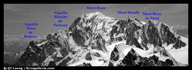
| Home/Mountain/Mont-Blanc Range information |
The closest towns are Chamonix and Saint-Gervais in France, Courmayeur in Italy.
In spite of the summer crowds, you should not underestimate Mont-Blanc. The combination of high altitude, relatively unstable weather, steep and/or exposed terrain, glacial features, orienting difficulty can be quite serious. You need at least to be in excellent shape, and to have previous mountaineering experience including a few long outings, use of the rope to prevent crevasse falls and climbing falls, use of an ice-ax and crampons, cold weather/storm skills. In doubt, it is better to use a guide service. The seriousness of Mont-Blanc in my opinion is at least comparable to that of Rainier.
It is best to arrive in good shape. If the weather seems stable, do another climb before to acclimatise, otherwise go for the first good window. Some very pretty high altitude climbs which are easy to access using the cable car are the Midi-Plan ridge and the Rochefort ridge. Whatever you do, go to the OHM (if you don't know what this means, see here) and ask for advice and conditions there. Another way to acclimatize is to go by feet without any mechanical transportation, however with my previous suggestion you get more exposure to high altitude. It is difficult to say what level of acclimatisation is necessary since this tolerance to altitude depends a lot on individuals. Some take the train from Paris (sea-level), and sleep the next day fine at Gouter or Cosmiques, other would get very sick. However folks who have spent at least an entire day at 4000m, and slept above 2500m seem to fare ok, and that's the minimum that I would recommend. The more duration and height, the better.
Starting from September, the range can have either long periods of very stable weather without the summer thunderstorms (like in Oct 95) or either continuously lousy weather (like in Sept 95). The traffic is lower in September than it is during July and August, but still significant. Usually by mid-October to end-October, there is too much snow, the days get quite short and cold, and most people consider that the winter season has begun. Fall and early winter are however the times when the crevasse situation is the worse. The Grands Mulets route might not be usable at all if the fixed ladders are not in place below the hut.
The conditions in winter are very variable. I know that although you usually need to use skis, there are times when the snow is hard enough that you don't need them. The steeper it gets, the more this is true. For this reason, for instance the routes on the Brenva face are usually quite climbable even during the winter. You might want to watch for avalanches, and weak snow bridges. Both are a very serious problem in winter, and tend to improve as the season goes, since the snow stabilizes, and the bridges fill up. You have to decide whether you want to do an ascent on foot or on skis. In the first case, you should attempt the Gouter Route, since because of the wind, it is the most likely to have packed snow. In the latter case, the Grands Mulets route, done generally in spring, should have conditions good enough, but don't try in on foot since it will probably have lots of snow. The Trois-Mont-Blanc route has generally a high avalanche hazard during the winter. Expect very cold temperatures, and make sure that you get recent information from OHM.
By the spring, it is usually prime time for a ski ascent of Mont-Blanc. The most popular period for this is from April to beginning of June, although I believe that a ski ascent might be possible also during the summer. During spring, there is usually too much snow for an ascent without skis.
The Gouter route is indeed very crowded. The Grand Mulets and Trois-Mont-Blanc routes are a bit crowded. If you tackle Mt Blanc this way, well, you should be warned beforehand about this fact. It is well known, so this is only your choice to go on a crowded route. However, there are plenty of routes on the same mountain which do not suffer this affliction. For instance, when I did the first solo ascent of the Jaccoux Domenech route on the W face, I didn't see anyone during 24 hours. A route of moderate technical difficulty (PD) which sees almost no traffic is the Tournette Spur in the W face (a more ambitious project than the rating would indicate).
Generally speaking, with the exception of Dent du Geant/Aretes de Rochefort, the Italian side of the range is not so crowded. I recommend as nice and uncrowded routes (haven't done them personnally): (a) the traverse of the Aiguilles de Tre-la-Tete (b) Mont Dolent
A note on the Vallot hut: this is an emergency shelter which is meant to be used by climbers coming late from the long and difficult routes of the Italian side, and by climbers caught in a storm. It has saved many lives. Please don't plan to use this hut to climb one of the regular routes. If you use this hut because you feel sick, please don't add more garbage.
If a white-out occurs on your summit day, above the Vallot Hut, no real problem: follow the Bosses ridge, and use the altimeter to locate the Vallot Hut. The trouble begins under the Vallot hut. In bad weather, the best is to loose altitude fast by descending the Grands Mulets route. Due to its lower elevation, the trail remains longer too. However, there are a couple of flat sections (esp. Grand Plateau) where orienting is difficult. If you loose your way here, you can end up in quite dangerous terrain (seracs). The traverse of the Gouter Dome is safer, but orienting is also quite difficult, you will not loose altitude that fast, and the trail might be wiped out faster. Be prepared to make extensive use of the compass.
Below are a few notes on these routes. Please note that they are not meant to be complete descriptions. You should get a guidebook and maps. All these routes are normally completed in two days. First day you get to the hut, second day you summit and go down all the way to the Valley.
Great www site with many informations.Contributed by Justus Koch (jukoch@stud.uni-frankfurt.de) on January 7, 1998.i made an ascent using the normal route last year in june. before this time i stood two other times on the top of europe, using different routes. your informations are very objective !
Maybe you will set a link to the following url:
http://www.wiwi.uni-frankfurt.de/~jkoch
in this url i give informations for mountaineering at the mont blanc in german language. so this page might be of interest for the visitors of your site too.
i would be glad for having a link in your site
greetings
Justus Koch, Germany
Very nice information indeed! Last year a friend and I climbed Tournette-spur on MB, more or less inspired by your website. It was very, very nice! Only underestimated the time needed. Started at 02:00, end of the ridge at 18:00. A lot of glazed rock. Did not go to the top but descended to Vallot immediately, where we arrived at 19:45. Later we reached the top from Rif. Torino by the long route over MB du Tacul and M. Maudit. But Tournette was much nicer! Thanks for the info,I will go back there certainly. Also wrote a short story about Tournette, so if you are interested, write me an email. Regards, Pedro.Contributed by Peter Verburgh (verburgh@rikz.rws.minvenw.nl) on March 25, 1998.
The route information, I found to be very useful!Contributed by Jonathan McEwan (jmcewan@hpbidrs0.bbn.hp.com) on July 10, 1998.Other interesting routes in the area is Mt. Buet, on the other side of the Chamonix valley, near Vallorcene. At 3100m it is a fairly easy route even in late may (with exception of the weather - if the weather is bad, watch out for avalanches and particularly rock slides).
The 2h1/2 walk from Vallorcene to the Refuge du Benard at 2020m can be done by nearly anyone, and puts Mt Buet within 5 hours walking distance.
The route is a high altitude walk and is very crowded in the summer. However, in the between season months it is peaceful. ( mid may to mid june - early sept - late sept ). If you are going in the spring months, try to have a good idea where the rivers are running under the packed snow. It is not advisable to transverse these areas. The snow line moves from about 1800m to 2500m between mid may and mid june, and then to above 3000m in the summer.
This is a good ''test'' route for those wishing to climb the surrounding peaks. By the way, most of the refuges don''t open until mid June.
60 or so people died last year on Mt Blanc, and this spring they were still finding missing climbers. Agreed, just because there are alot of tourists, doesn''t mean its ok to be equiped like one...
coolness.
some tips about Mt. Blanc: Anyone attempting to get to the top of Mt. Blanc should also bring an ice axe. Rope and crampons are absolutely requiered for traversing the glacier - there are numerous, dangerous crevasses. For those who become members of the french montaineering association, rescue is included. If you've got a GSM cellular, it works really well in the mountain. Remember to keep it in a dry and warm place to keep the batteries alive.Contributed by Randi Skaug (raskaug@online.no) on September 20, 1998.
The Mont Blanc is half italian and half french!!! That is the real state border, also if some french people modify it on the tourist's maps.Contributed by Max Moscarello (mmoscarello@ntt.it) on December 15, 1998.Thanks
I thought that this site is really informative and helpful. It espeacially helped me with climbing this great mountain!!! thanks Fred wilsonanonymously contributed on June 11, 1999.
An excellent website informative and well presented a pleasure to read and a great help to my triumphant plans, thanks!Contributed by Duncan Law (lawdjf@k.e.s.b'ham/com) on January 10, 2000.
I thought Mont Blanc was going to be a plod! i was wrong. It can be very tough. I did it from the valley up - no lifts or trains - and back in three days. Tough on the knees, 13,000 ft. up and down. However, it is very beautful. I did the Gouter ridge route in late September. Day 1 - Starting in the valley, up to the Tete Rouse Hut and overnight. Day 2 - Tete Rouse Hut to the summit and back to the Gouter Hut Day 3 - From the Gouter Hut to the valleyContributed by Graham Meigh (graham@stepbeyond.co.uk) on March 4, 2000.This is hard, because of the 7/8 hour summit day.
On the way down traversing the Dome de Gouter in a white we lost the descent route and almost walked over seracs. In ghese conditions it can be very, very serious. But, this is mounta
The walk from Aig. du Nid to the Gouter Hut is longer & harder than people think! Brits should take their BMC card as this gives you a discount at the Gouter Hut. For approx. #20 you can get a bed & an evening meal at the Gouter - worth the cost, especially if you summit. The walk up from the Col du Dome (Gouter) to the Refuge Vallot is a bit of a ball-ache and you should rest there. Don't stay too long - keep moving ( drop excess kit at hut). Good luck on the ridge & be careful of side winds.Contributed by Sean Cashin (seancashin@hotmail.com) on June 7, 2000.
Mont Blanc is indeed crowded in summer, but it is worth giving it a try anyway. We were 4 guys climbing it this juli 7 2000 and the weather was very unstabel but just good enough to put 3 of us on the summit. Unfortunately the one that didn4t make it further than Vallot hut (4200 m.)was me, due to exhaustion, caused by altitude sickness the previous day. Don4t take it lightly about the altitude; even 3500 m can cause headaches and plain discomfort if you don4t take your time to aclimatize properly. The overall experience is so much greater if you do. I had a wonderful experience on MB, but it would have been even greater if I had been on top along with my friends. Chris !Contributed by Christian Als (christianals@hotmail.com) on August 18, 2000.
In the summer of 2000 we took the following route up Mont Blanc: Day 1 - Cable car from Les Houches to Bellevue, then follow the train line to Aigle du Nid (have a coffee at the cafe). This walk is good for acclimatisation.Contributed by Sean Cashin (seancashin@hotmail.com) on February 9, 2001.From here you continue up and we stayed in a disused hut (Foristiers or Foresters?) about 1 hour along the trail. It was very cold in there and quite busy (take sleeping bag & mat).
Day 2 - we walked to the Tete Rosse hut and stayed there. This gives you plenty of time to chill out etc. (alternatively you could climb up to the Gouter hut, a further 2 hours away).
Day 3 - Climbed up the ridge, crossing the Bowling Alley (no big deal, but that is my opinion). Ended the climb at the terrace of the Gouter hut. Left the following morning at 2am for the walk up and over the Dome du Gouter, Col du Dome and up to the Vallot hut (steep here).
Dropped off kit, had a drink and continued up. Going got hard here, up and over the two 'big boobs' and onto a long snow ridge (narrow in places). It was extremely windy here.
We carried on to within 200 metres of summit and turned around due to sickness of a partner (coughing blood) and fatigue.
A great few days, we'll be back this year!
There's a number of things I wanted to add that might be of vital interest to climbers attempting MB on the regular (Gouter) route:Contributed by Sascha Moench (sascha_moench@hotmail.com) on February 16, 2001.1. I climbed it in early September (1999, though); VERY GOOD time!! By far less people (approx. 70) up there than (supposedly) in July or August. Weather still very climber-friendly. However - if there's a nice weather "window" during that time, watch you are on that mountain as early as possible. As son as people get the impression that the weather will be stable for a few days, they are starting the season's last rush on MB. I had to cope with serious traffic (up) on my way down the W face of Aiguille du Gouter.
2. Don't think it's just the Grand Couloir ("death gully") itself that is exposed to rock fall. Also the ridge to the left (where you start crossing the gully) can be problematic. I've seen a dude have his leg smashed by a car wheel sized rock, there. And don't underestimate the rockfall in the actual gully, either: on my way up, the fixed rope was still properly in place. The next day it was gone!!
3. If you're one of the first teams to reach the summit in the morning, be prepared for sometimes tricky and close encounters with ascending parties on your way down the Bosses Ridge - there are places where it's actually quite narrow.
4. Don't plan to have a long break at Vallot hut on your way up. Once you've cooled down, you're gonna have a hard time getting up again!
5. If you are in good shape and quite an experienced climber, avoid to employ a guide to take you up there! If you're good, you will make it by yourself. If you're not good, you shouldn't be on that mountain, but guides would take you anyway, no matter what the risk - as long as they get paid.
6. At Gouter hut: if the owner tells you there are no spare beds, but only mattresses - don't panic! Since 1998, the hut has an annex that houses two gigantic bunk beds with 20 places each - that's what he means!
7. Don't do any bullshit on that mountain!
Greetings, Sascha
I really think that the coments by Sascha on the guides are really stupid. If someone is a professional climber fine, if not you would certainly be much better off with an expirience, entusiasthic and friendly guide. I have done the Valle blanche several times, and never without a Guide de Chamonix. Even when is crowded and you think is easy to follow the way, if you do not know the mountain you can face great problems in seconds. I think that to say that "you can saved yourself the money of a guide" is ridicolous and dangerous. You really shouldn't keep such a comment in a permanent way!Contributed by Fernando Suarez Mella (f.suarez@skynet.be) on March 4, 2001.
| Home/Mountain/Mont-Blanc Range information |